Transcription of VFR Cross Country Flight Plan Guide
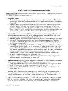
1 AeroDynamic Aviation VFR Cross Country Flight Plan Guide Day before Flight : 1. Gather current charts, A/FD, navigation log, POH performance data, Flight computer, etc. 2. Spread out charts and eyeball approximate route of Flight considering the following: Route: Try to choose the most direct route but consider terrain during the climb, en route and descent. Use victor airways, obvious landmarks, and navigation aids if available. Make sure there are easily identified checkpoints along the route. Power lines, private airports, and train tracks are usually not easily identifiable! Airspace: Avoid restricted airspace and MOA s. Plan for appropriate clearances, weather minima, and equipment required for class B, C, & D airspaces. Terrain: Make sure you don t have terrain along your proposed route that is higher than the aircraft s service ceiling. For safety make sure you have at least 2000 foot obstacle/terrain clearance.
2 Airports: Make sure there are appropriate (runway lengths & available services) airports for needed, planned or unplanned stops. Fuel: Do you need a fuel stop? At what fuel indication would you divert for fuel? How much are you landing with? Does your destination have fuel services and available 24 hours? Emergencies: In case of an in- Flight emergency make sure there are suitable landing sites (on and off airport). Don t fly long distances over lakes or open water. Night: Cities and highways are most of your visual references at night. Be especially alert to mountainous terrain, instrument conditions, airport lighting availability, and emergency landing sites. Pack a flashlight, extra batteries, and emergency supplies. 3. Use plotter and pencil to draw intended route of Flight . 4. In your navigation log, begin to enter the structure of the Flight plan. Some of the details will be added later with current weather.
3 For now, start with the departure airport in the first Checkpoint box. 5. The first checkpoint should be an easily identifiable point approximately 10-15 miles from the departure airport. It usually goes along with the Top of Climb. The Top of Climb is the point at which the airplane reaches its initial cruising altitude. This point is determined from the climb performance charts in the POH. The Top of Climb will be determined when you get the weather for the Flight , as it is determined by winds and temperatures. 6. Identify and mark an X at each checkpoint along the route. The check points should be evenly spaced along the route and have clearly visible references (freeways, airports, tall towers, cities, etc.). The route should have checkpoints approximately every 15-20 miles. If your airplane s airspeed indicator is in MPH instead of KTS, you should use statute miles for distance but will need to convert winds aloft from KTS to MPH.
4 7. In the Checkpoint box enter or draw a description for each checkpoint you identified, intersection of roads, which airport, height of tower, etc. and the distance to the next checkpoint. AeroDynamic Aviation 8. If the checkpoint is identified by a VOR, NDB, Cross radials, etc., enter each Nav Aid name, Frequency, OBS setting, and note whether there will be a To or From indication. 9. If communications are required (transitioning airspace, Flight following, Flight service station, etc.), write who you ll need to contact and the frequency in the Comm and Freq box. 10. For each checkpoint, enter the Route and Altitude you plan to fly to each checkpoint and enter that information in the Route and Alt boxes. 11. Use plotter to find the True Course you ll fly to each checkpoint and enter the value in the TC box. Use longitude lines and try to measure the True Course near the midpoint of the leg.
5 12. After you find the True Course to the checkpoints, use the plotter to find the distance between checkpoints and enter the value in the Leg Dist box. Make sure you use the correct scale (Sectional or VFR Terminal, NM or SM). You can do this for each checkpoint except for the Top of Climb (Because you don t know where this is yet) and the checkpoint following the Top of Climb. 13. Use the chart to find the Magnetic Variation for each leg and enter that information in the Mag Var box. If the variation is not a whole number ( 13 30"), round to nearest number. 14. Choose Altitude in reference to Magnetic Course (E is odd +500 from 0-179 and W is even + 500 from 180-359 ), Winds Aloft, Airspace, Duration of Flight , Performance, Terrain, Emergencies etc. 15. List airport information and draw small diagram. Write important info like Twy A closed, which you found in NOTAMs.
6 Draw traffic patterns in relation to which direction you will be arriving from. This helps you determine how to enter the pattern for whichever runway is in use. Day of the Flight : 1. Go to Under the Tools tab, select Standard Briefing and review all. 2. Use METARs, TAFs, and Winds Aloft to calculate takeoff, climb, en route and decent performance, WCA, and GS. * Remember that winds aloft are given in True Course and in Knots. Convert to magnetic and/or miles per hour if needed. 3. Refer to NOTAMs, TFRs, Area Forecast, Prog charts, Airmets, Sigmets, Convective Sigmets, Pireps, and TAFs en route to determine if Flight can be accomplished. 4. Calculate when/where TOC will occur and complete Flight plan boxes for ground speed, time, fuel burn, and magnetic heading. Calculate when you will need to begin decent to TPA (TOD). 5. Once you have determined Mag Heading (MH) and know which airplane you will fly, calculate Compass Heading (CH) by applying Deviation from the Compass Deviation Card of that airplane.
7 6. Do your Performance Sheet and your Weight & Balance for each leg. AeroDynamic Aviation 7. Calculate Groundspeed, CH, MH, time between waypoints, time enroute, fuel consumption, fuel required, etc. Note which power setting (RPM) you selected for cruise so you set it in Flight . 8. Finalize your Sectional Chart by marking the route of Flight in color ( yellow marker). Circle your checkpoints in a different color. 9. File your Flight plan and obtain a weather briefing. Review NOTAMs, TFRs, and all pertinent data. 10. If you are a student pilot, get endorsement(s) from your Flight Instructor and leave a copy of your Flight plan with the office. VOCABULARY NM = nautical mile SM = statute mile TOC = top of climb (derived from POH or Aircraft Flight Manual) TOD = top of descent (often based on 500 foot-per-minute rate) POH = Pilot s Operating Handbook TC = True course, the line drawn on your chart TH = True course adjusted for wind correction angle (WCA) WCA = wind correction angle MH = True heading adjusted for magnetic variation (VAR) CH = Magnetic heading adjusted for compass deviation (DEV) MC = True course adjusted for magnetic variation; used for determining even or odd altitude to fly, and used when flying VOR courses or Victor Airways (VORs give magnetic courses) FORMULAS TH = TC +/- WCA MH = TH +/- VAR CH = MH +/- DEV MC = TC +/- VAR WCA (wind correction angle) is achieved by taking True Course and adding or subtracting based on E6B calculations of where the wind will blow you.
8 This will give you True Heading. We apply this before variation because the winds aloft are true, not magnetic. Magnetic variation around us is 14 degrees E, so we subtract 14 from True Course to get Magnetic Course or -14 from True Heading to get Mag Heading. These lines are long dashed magenta strewn across the sectional charts. Wind adjustment converts course to heading. Variation adjustment converts true to magnetic. Deviation adjusts for errors in the compass caused by airplane systems. AeroDynamic Aviation First, remember that this log is for your use. No sense in filling it with so much info it is unreadable. Second, Flight planning is done primarily to calculate fuel, time, distance, and navigation to get from one place to another. Now let s talk about the boxes: what they mean and how to use them. -The top section can be used for performance and is fairly self-explanatory.
9 You ll get this information from the POH, but use temperatures and pressures from the day of the Flight . - Checkpoints: Your departure airport should be the first checkpoint. TOC (top of climb) is generally the second checkpoint. If you make a turn before TOC, then enter a location or landmark where the turn will be made and move TOC to the third checkpoint box. Checkpoints should be noted approximately every 10-15 minutes (approx 15-20 miles). - VOR Freq/Ident: If you are using VORs for navigation, either on airways or as checkpoints, enter the VORs frequency in the top half of the box and the name of the station ( SNS, SJC, etc.) in the bottom half of the box. - Course: Magnetic course determines our altitude (E is odd + 500 , W is even + 500 ) and is also what VORs use. Magnetic course is derived by taking true course +/- magnetic variation (TC VAR = MC)