Transcription of VHF R/T Port Operation Channels - Southampton VTS
1 VHF R/T Port Operation ChannelsYachts are reminded that channel 16 is a DISTRESS SAFETY AND CALLING channel ONLY. Other than for distress it must only be used to establish contact before going to a working channel . Port Operation Channels must not be used for boat communications. The recognised boat to boat Channels are 6, 72 and Operation Channels are as follows:12 Vessel Traffic Services (VTS)14 Southampton Harbour Master11 Queen s Harbour Master, Portsmouth68 Harbour Master, Hamble69 Harbour Master, Cowes67 HM Coastguard73 Working channels71 Ship/tug/pilot working channels74 NOT TO BE USED BY 10 RECREATIONAL CRAFT 09 0880 Marina working channelsVESSELS OVER 20 METRES MUST REPORT TO VTS AT DESIGNATED REPORTING POINTS (AS PER ADMIRALTY CHARTS AND ALRS VOLUME SIX)}}}The yachtsman s guide to Southampton Waterand it s approachesIf you can t see the ship swheelhouse, the ship can t see you!
2 Welcome to the Port of SouthamptonThis information has been produced by Associated British ports specifically for people who enjoy recreational activities facts you should keep in mind:1. The number of large commercial ships serving the Port of Southampton and the number of recreational craft afloat in local waters is increasing. It is essential that close quarters situations are minimised. 2. Most of the commercial vessels you meet will have a UK Pilot on board regardless of the ship s flag. They will be monitoring VHF channel 12. 3. Most ships travel at manoeuvring speeds of between 10 and 15 knots whilst in the Solent and Southampton Water. This will vary from ship to ship and is as safe as navigation and conditions permit . 4. Light, partially loaded or unevenly trimmed ships may require to maintain a higher as safe as navigation permits speed to remain under full control.
3 5. It may take less than 10 minutes for a ship to reach you from your visible horizon, in hazy conditions it will take a lot less. At 10 knots a ship travels one nautical mile in six minutes. At 15 knots it takes only four minutes. 6. Ships cannot easily avoid small craft in narrow Channels , it is better for you to stay clear. 7. A large ship that is slowing down may not steer very well, it needs propeller action on the rudder to respond. When the ship s engine is put astern it s manoeuvrability will be affected. Remember that it takes time and a considerable distance for a ship to stop. 8. There are numerous other small vessels operating within the Solent and Port of Southampton . Watch out for ferries, fast catamarans, fishing boats and tugs towing barges (especially at night when barges may not be clearly visible).
4 Note that a towing cable may be partially can you do? 1. Whenever possible, avoid sailing in commercial shipping Channels , especially in poor visibility. If it is absolutely necessary to use these Channels then observe Rule 9 of the COLREGS by keeping to the starboard side of the channel and crossing, at right angles, only when this does not impede the passage of a vessel that can safely navigate only within that channel . 2. Do not underestimate the speed of ships. If your vessel is slow, allow sufficient time to take any necessary action. 3. Be visible. At night, make sure your navigation lights can be seen. If you suspect that you have not been seen by an approaching ship shine a torch, searchlight or spotlight on your mast or sail. Carry a radar reflector high on your mast. Remember that from the bridge of a large container ship or tanker the Pilot or Master may lose sight of you up to half a mile ahead even though you can see the ship quite clearly.
5 4. Be alert. Keep a good lookout at all times, especially astern! 5. Night-time sailing. Even on a clear night you may have difficulty seeing a ship approach. You might notice it first as a black shadow against a background of shore lights, or as a growing shadow at that point you are not far apart! Remember that your lights may not be easily spotted from a ship, especially lights at the top of your mast which can merge with Collision Avoidance Check List Avoid ship Channels when possible. Cross them quickly and at right angles Be alert, watch for ship traffic Be seen, especially at night Know whistle signals- five or more short blasts, your intentions are not understood! Listen to VHF channel 12 - if you have to transmit keep your message brief Use up to date navigation charts - read Local Notice to Mariners at your local club/marina or on When in doubt, keep clear.
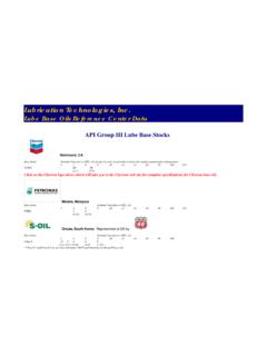
6 Always be prepared for the unexpected Lifejackets do not help if you re not wearing them!TypicalSouthamptonTidal Curves For Springsand :00 3:0 6:00 9:00 12:00 15:00 18:00 21:00 00:00 TimeMetresDock Head Spring Tide Curve Dock Head Neap Tide CurveMean Tide LevelSecond Flood StandLow WaterNeapsSpringsFirst SpringsChart Datumbackground shore lights when viewed from a large commercial vessel. 6. Study the ship s lights. If you can see both sidelights you are dead ahead and need to react quickly. 7. Precautionary Area. See Caution One on the accompanying chartlet. Be aware that ships make large alterations of course at the West Bramble and Calshot turns.
7 Ensure that you comply with the MOVING PROHIBITED ZONE. 8. Recognise whistle signals. Five or more short blasts means your intentions are not understood and you are causing concern to the ship. One short blast means the ship is altering course to starboard. Two short blasts, altering course to port. Three short blasts the ship is putting engines astern. 9. Know ship signals. A ship which displays a black cylinder in the daylight or three red lights in a vertical line at night indicates that she is constrained by her draught. Give her a wide berth. 10. VHF Channels . Keep your radio on channel 12 which is the port working frequency used by Southampton Vessel Traffic Services (VTS) and shipping. Every 2 hours from 0610-2210 there will be a broadcast on channel 14 ( pre-empted by a transmission on channel 12) giving information on large ship movements, local weather conditions and any new Navigational Warnings.
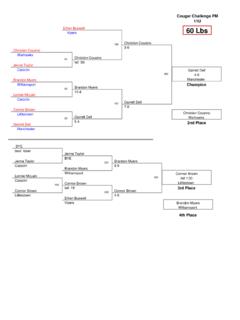
8 Personal Watercraft (PWs)PWs, otherwise known as jet-skis and waterbikes, are required to exercise caution with due regard to other water users when in the Port of Southampton and approaches. When close to the shoreline, in particular, keep a good lookout for swimmers. Be aware of your speed and keep clear of ships and other craft. Always wear the Kill Cord. The 6 knot limit in the Docks applies to all powered craft! Hamble Point MarinaPort Hamble MarinaOcean Village MarinaTown Quay MarinaHythe Marina VillageShamrock QuaySaxon WharfKemps MarinaSwanwick MarinaWarsash SCHamble River SCRoyal Southern YCRAF YCNetley Cliff SCWeston SCHythe SCCrackmore Hard SCCalshot SCFawley Power Station SCRoyal Yacht SquadronRoyal London YCIsland SCCowes Cornathian YCSolent BreezesAshlett SCSouthampton SCSouthampton Harbour MasterVessel Traffic Services Centre (VTS)Royal Southampton YCHamble Harbour MasterWarsashDP WorldContainerTerminal SeeContinuation BelowHusband sShipyardMarchwoodMilitary PortDibden BayPort Development LandHytheCalshotFawleyChimneyFawleyPort LimitPort LimitCalshot Radar TowerTHORN CHANNELCALSHOT REACHNORTH CHANNELT ypical track of commercial vessels atEbbtide (Floodtide)
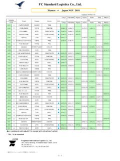
9 WesternApproachChannelWoolstonWestern DocksItchen Bridge( above chart datum)SouthamptonCollege of Maritime StudiesHookHambleUniversal MarinaMercury Yacht HarbourOSBORNE BAYSee Caution ThreeUpstream of this lineMAX SPEED 6 KnotsNetleyNW NetleyMoorheadWeston ShelfHythe KnockGympGymp ElbowEastern DocksPier HeadDibden SGDeans ElbowHoundBird PileLains LakeAfter BarnGreenlandCadlandBP Hamble JettyHamble PtBald HeadCoronationBlack JackReachCastle PtCalshot SpitCalshotBourne GapNorth ThornWest KnollBramble BankBnEast KnollSouth BrambleStansore GurnardNorrisGurnardEgypt PointOld Castle PointHill HeadIsle of WightEast LepeGurnard LedgeStone KnollWest BrambleHookFawley MarineTerminalAshlett CreekLepe SpitPrince ConsortW RydeMiddleMarchwood ChannelEling SCMarchwood YCWaterskiing AreaSee Caution TwoSymbols KeySlipwayRecommended Crossing PointsNOT TO BE USEDFOR
10 NAVIGATIONC ausewayPrecautionary AreaSee Caution OneBeaulieu RiverHythe Marina Village02380 207073 Kemps Marina02380 632323 Ocean Village Marina02380 229385 Shamrock Quay02380 229461 Town Quay Marina02380 234397 Hamble Point Marina02380 452464 Port Hamble Marina02380 452741 Mercury Yacht Harbour02380 455994 Swanwick Marina01489 884081 Universal Marina01489 574272 DieselPetrolBottled GasElectricityShowersLaundretteLaunching SlipBoat HoistScrubbing BerthProvisionsBarVHF RadioRecyclingSewage Waste DisposalOil Waste DisposalRubbish BinsBoat YardVisitor MooringsAvailableAvailable Saxon WharfAvailable Hamble Yacht ServicesSouthampton Marina FacilitiesFor centuries the Port of Southampton has played a vital role in British sea trade and is situated on one of the finest natural harbours in the world. Southampton Water and it s approaches offer any leisure user excellent sailing waters and numerous facilities from the Isle of Wight to the Rivers Test and guide is designed to provide yachtsmen with a level of information which will contribute to the safe navigation and enjoyment of the One Precautionary Area All vessels over 150m in length, whilst navigating this area, will have a MOVING PROHIBITED ZONE 1000m ahead and 100m to either side.