Transcription of VOLVO C30 C70 & XC90 VOLVO NAVIGATION SYSTEM (VNS) …
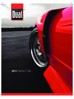
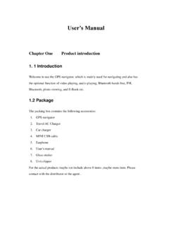
1 VOLVO C30, C70 & xc90 VOLVO NAVIGATION SYSTEM (VNS)Web EditionOPERATING MANUALG033441 Types of roadsColorFreewaysGreenMain roadsRedSecondary main roadsBrownNormal roadsDark grayLocal roadsDark greenText and symbols on the screenArea to be avoidedDistance to the next guidance pointDirection to take at next guidance pointType of junctionIntermediate destinationName of next street or roadNext guidance pointStored locationSymbol for a Point of Interest POI (Gas station)Remaining time to destinationRemaining distance to destinationMap scaleRouteCurrent roadFinal destinationFamous landmarksThe vehicle s current locationCompleted section of the routeStarting pointTraffic informationOuter ring of compass direction to destinationCompassVOLVO NAVIGATION SYSTEM (VNS) WITH RTTVNS is a NAVIGATION SYSTEM developed by VOLVO , which is designedto help guide you to the destination of your choice and provide infor-mation along the (Real Time Traffic) is an information SYSTEM developed by VOLVO ,which can detect roads/streets with traffic disruptions and make itpossible to select an alternative route past the problem SYSTEM includes features that enable you to set itineraries, searchfor certain types of points of interest along your route, store specialdestinations, obtain traffic informaton en route, SYSTEM indicates the vehicle s current location, and shows partor all of the route to your destination, depending on the settings youhave made.
2 If at any time you should decide to deviate from the routeoriginally set by the SYSTEM , a new route to the destination will auto-matically be enabling you to reach your destination quickly and by the mostdirect route, VOLVO 's NAVIGATION SYSTEM also helps contribute toimproving the DATABASE End-User License AgreementSee the information on page see page Option. Not available in all Getting to know thenavigation systemThis 8 Before you 9 NAVIGATION SYSTEM , updating and 11C30 SYSTEM 12S40 SYSTEM 14V50 SYSTEM 16C70 SYSTEM 18XC90 SYSTEM 20 NAVIGATION SYSTEM 22On-screen 23 Display and voice 24 Unverified roads and 26 Menu 270202 Easy user modeMain menu, Shortcut menu, Scroll menu. 32 Menu 33 Setting a 34 Show/Remove 380303 Advanced user modeMain menu, Shortcut 42 Map scroll 45 Menu 46 Setting a 53 Next 55 Current 56 Traffic information (option).
3 58 SYSTEM 62 Contents30404 Traffic 66 Avoiding traffic problems .. 67 Selecting 69 Reading 700505 Symbols on the mapRoad numbers and Points of 740606 Questions & answersFrequently asked 80 EULA End User License 82 Contents40707 8 Before you 9 NAVIGATION SYSTEM , updating and SYSTEM 12S40 SYSTEM 14V50 SYSTEM 16C70 SYSTEM 18XC90 SYSTEM 20 NAVIGATION SYSTEM 22On-screen 23 Display and voice roads and 26 Menu 27 GETTING TO KNOW THE NAVIGATION SYSTEM01 Getting to know the NAVIGATION systemThis manual 018 Using this manualThe manual is divided into chapters describingthe various features and functions of the navi-gation section dealing with common questions andanswers, and an index, can be found at the endof the selections/PathsMenu selections are shown in gray text in thismanual, for example.
4 Set destinationAddressCityChanges in the manualThe specifications, design features, and illus-trations in this manual are not binding. Wereserve the right to make modifications withoutprior notice. 2009 VOLVO Car Corporation01 Getting to know the NAVIGATION SYSTEM Before you start019 IntroductionThe VNS SYSTEM can be used even if a desti-nation has not been vehicle s current route will be shown on thescreen and the vehicle s position will be indi-cated by a blue arrow on the SYSTEM s contents may vary from state tostate, and not all menu selections may be avail-able for technical upThe SYSTEM starts up by displaying text on thescreen that must be confirmed by pressingENTER after you have selected to use eitherEasy mode or Advanced modeWhen the SYSTEM has started, the screen willdisplay the main menu briefly before enteringMap mode. A map of the vehicle's current loca-tion will then be displayed.
5 Press BACK to display the main menu. Press ENTER to activate the shortcutmenu. Press the NAVIGATION control to activateMap scroll mode, for example to see partsof the map that are outside of the ENTER in this mode activates theMap scroll menu, see page ignition must be in position I or II in orderto operate the SYSTEM (refer to the vehicle sowner s manual). Press ENTER or screen will slide up from the dashboardautomatically. It may take several seconds forthe SYSTEM to determine the vehicle s locationand the NAVIGATION control to go to ENTER (press BACK to go to themain menu before shutting down).The screen will retract automatically into SYSTEM can be used even if the engineis not running. It should be turned off whennot in use to help avoid battery SYSTEM is provided with default settings,but it will start with the settings that were mostrecently a setting is changed and you wish to returnto the default setting, only the currentlyselected function will be is no global reset function to return allsettings to Getting to know the NAVIGATION systemBefore you start 0110 Easy/Advanced modesWhen the NAVIGATION SYSTEM is started, thedesired user mode can be selected.
6 EasyOnly the primary menus are available in thismode, and can be used to simply get directionsfrom point A to B. AdvancedThis mode makes all settings and between modesSwitching between modes can be done made in Easy mode are not used ifthe SYSTEM is switched to Advanced mode,and vice versa. Settings are stored in themode in which they were (simulated guidance)The NAVIGATION SYSTEM contains a function thatdemonstrates guidance to a destination. How-ever, please be aware that the demo can onlybe run when the vehicle is at a function is only available when VNS is inAdvanced mode, see Demo on page Getting to know the NAVIGATION SYSTEM NAVIGATION SYSTEM , updating and care0111 Contents of the main unitAll map information is stored on the main unit shard drive. There is no DVD in the unit when itis delivered. The DVDs are used for anyupdates to SYSTEM or map information, see theinstructions of the DVD s DVDs are issued on a regular basis withupdated and new information.
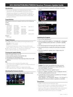
7 The latest DVDscan be purchased from a VOLVO cannot be responsible for the accuracyor completeness of data, maps, or routingguidance presented by your NAVIGATION sys-tem. Please contact the map developer, Nav-Teq at main unit s DVD player is intended forVolvo DVDs with a DVDNOTEP lease note that an update may take up to90 minutes. Be sure the vehicle s battery isadequately charged before a DVD contains new SYSTEM software in addi-tion to map information, the SYSTEM will beginby running the software vehicle can be driven while the navigationsystem is being updated, but VNS cannot beused while the update is in perform an update:1. Switch on the NAVIGATION Remove a DVD if one is already inserted inthe SYSTEM s DVD Insert the DVD containing the updatedinformation. If there is more than one disc,insert them in the numbered The SYSTEM will now be automaticallyupdated.
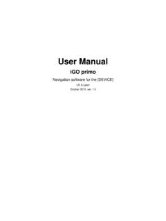
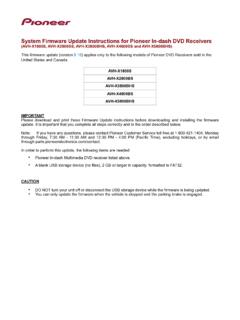
8 Information will be displayed toshow update After the update, the DVD containing themost recent update must remain in thesystem s DVD player. If more than one dischas been used, insert disc 1. If the disc isremoved from the player, the navigationsystem will stop the SYSTEM is switched off while an update isin progress, the update will be resumed thenext time the SYSTEM is switched certain cases, updating map information willadd new SYSTEM VNS start screen will be displayed whenupdating is care When changing discs, make sure that theyare kept free of oil, grease and other impur-ities. The discs must not be exposed to mois-ture. The discs must be kept in their packagingwhen not in use. Avoid storing discs inexcessive heat, direct sunlight or in a careClean the display screen with a soft, non-staticcloth or a moist paper towel and a mild windowcleaning use petroleum based solvents or abra-sive substances when cleaning the Getting to know the NAVIGATION systemC30 SYSTEM overview 0112G01963101 Getting to know the NAVIGATION SYSTEM C30 SYSTEM overview0113 Main unitThe main unit contains a hard drive, a DVDplayer (for NAVIGATION SYSTEM map discs only)and an integrated GPS (Global PositioningSystem) receiver and a TMC (Traffic MessageChannel) main unit has the following functions.
9 Calculates the vehicle s current position Calculates the route to the selected desti-nation Processes traffic information Provides voice guidance Stores map data Uses the DVD player to update map dataand SYSTEM softwareGPS receiverThe NAVIGATION SYSTEM uses GPS signals, thevehicle s speedometer and a gyroscope todetermine the vehicle s current location information TMC (option)1 TMC is a standardized code SYSTEM for trans-mitting traffic information. The receiver auto-matically tunes to the correct frequency andreception is handled by the audio SYSTEM s area covered by the SYSTEM is being stead-ily expanded, which makes occasionalupdates necessary, see page of whether the NAVIGATION systemis in Easy or Advanced mode, broadcast traf-fic information is always received and presen-ted. see page 66 for additional information. SpeakersSound from the NAVIGATION SYSTEM comesthrough the audio SYSTEM s front speakers.
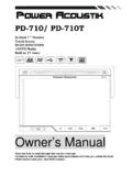
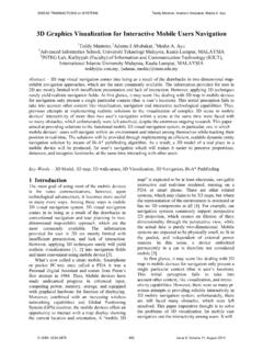
10 NAVIGATION controlSee page 22. ScreenThe screen displays the maps and providesdetailed information on intersections, dis-tances, etc. See page 11 for information oncaring for the screen. IR port for the remote controlSee page available in all Getting to know the NAVIGATION systemS40 SYSTEM overview 0114G01963201 Getting to know the NAVIGATION SYSTEM S40 SYSTEM overview0115 Main unitThe main unit contains a hard drive, a DVDplayer (for NAVIGATION SYSTEM map discs only)and an integrated GPS (Global PositioningSystem) receiver and a TMC (Traffic MessageChannel) main unit has the following functions: Calculates the vehicle s current position Calculates the route to the selected desti-nation Processes traffic information Provides voice guidance Stores map data Uses the DVD player to update map dataand SYSTEM softwareGPS receiverThe NAVIGATION SYSTEM uses GPS signals, thevehicle s speedometer and a gyroscope todetermine the vehicle s current location information TMC (option)1 TMC is a standardized code SYSTEM for trans-mitting traffic information.