Transcription of WATER WELL REPORT
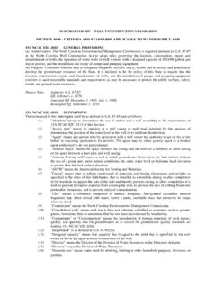
1 ECY 050-1-20 (Rev 08/19) If you need this document in an alternate format, please call the WATER Resources Program at 360-407-6872. Persons with hearing loss can call 711 for Washington Relay Service. Persons with a speech disability can call 877-833-6341. WATER well REPORT Type of Work: Construction Decommission Original installation NOI No. Proposed Use: Domestic Industrial Municipal Dewatering Irrigation Test well Other Construction Type: Method: New well Alteration Driven Jetted Cable Tool Deepening Other Dug Air- Mud-Rotary Dimensions: Diameter of boring in., to ft. Depth of completed well ft. Construction Details: Wall Casing Liner Diameter From To Thickness Steel PVC Welded Threa d | in. in. | | | in. in. | | | in. in. | | | in. in. | | Perforations: Yes No Type of perforator used No.
2 Of perforations Size of perforations in. by in. Perforated from ft. to ft. below ground surface Screens: Yes No K-Packer Depth ft. Manufacturer s Name Type Model No. Diameter Slot size in. from ft. to Slot size in. from ft. to ft. Sand/Filter pack: Yes No Size of pack material in. Materials placed from ft. to ft. Surface Seal: Yes No To what depth? ft. Material used in seal Did any strata contain unusable WATER ? Yes No Type of WATER ? Depth of strata Method of sealing strata off Pump: Manufacturer s Name Type: Pump intake depth: ft. Designed flow rate: gpm WATER Levels: Land-surface elevation above mean sea level ft. Stick-up of top of well casing ft. above ground surface Static WATER level ft. below top of well casing Artesian pressure lbs. per square inch Date Artesian WATER is controlled by (cap, valve, etc.)
3 well Tests: Was a pumping test performed? No Yes by whom? Yield gpm with ft. drawdown after gpm with ft. drawdown after gpm with ft. drawdown after data (time = zero when pump is turned off WATER level measured from well top to WATER level)Time WATER Level Time WATER Level Time WATER Level Date of pumping test Bailer test gpm with ft. drawdown after test gpm with stem set at ft. for hrs. Date Artesian flow gpm Temperature of WATER oF Was a chemical analysis made? Yes No Notice of Intent No. Unique Ecology well ID Tag No. Site well Name (if more than one well ): WATER Right Permit/Certificate No. Property Owner Name well Street Address City County Tax Parcel No. Was a variance approved for this well ? Yes No If yes, what was the variance for? Location (s ee instructions on page 2): WWM or EWM - of the ; Section Township Range Latitude (Example: ) Longitude (Example: ) Driller s Log/Construction or Decommission Procedure Formation: Describe by color, character, size of material and structure, and the kind and nature of the material in each layer penetrated, with at least one entry for each change of information.
4 Use additional sheets if From To Start Date Completed Date Driller Trainee PE Print Name Signature License No. IF TRAINEE: Sponsor s License No. Sponsor s Signature Drilling Company Address City, State, Zip Contractor s Registration No. Date well CONSTRUCTION CERTIFICATION: I constructed and/or accept responsibility for construction of this well , and its compliance with all Washington well construction standards. Materials used and the information reported above are true to my best knowledge and belief. 050-1-20 (Rev 08/19) If you need this document in an alternate format, please call the WATER Resources Program at 360-407-6872. Persons with hearing loss can call 711 for Washington Relay Service. Persons with a speech disability can call well /DEWATERING SYSTEM CONSTRUCTION PROCESS After a well is constructed, modified or decommissioned, a well REPORT must be filed within 30 days to the Department of Ecology. well reports are filled out by the person who constructed the well .
5 This is typically a Washington State licensed well operator. The following form is used for WATER wells and dewatering systems only. Below are the instructions for filling out a WATER well REPORT . After the form has been printed and filled out, it should be mailed to the Department of Ecology Regional Office responsible for the area the well work was conducted. INSTRUCTIONS Type of Work This form is used for BOTH construction and decommissioning of a well . Please check the appropriate box. For decommissioning enter the original construction Notice of Intent No. here (if available). Dimensions Nominal diameter of uncased boring (drill bit size) and total depth drilled. Depth of completed well may be different from total depth drilled. Construction Details Choose either Casing or Liner. Enter nominal diameter and depth range. Check the type of material and whether it was welded or threaded. A description of mechanically locked liners may be added to the Driller s Log/Construction Procedures section.
6 Perforations well casing perforations; read each statement and answer appropriately. Screens well screens and screen assembly information. A K-packer is designed to provide a sand tight seal between a well screen assembly and casing. Sand/Filter Pack Read each statement and answer appropriately. Surface Seal Read each statement and answer accurately. WATER Levels Casing stick-up means the height, in feet, the well casing rises above ground surface (preferably measured to the hundredth [ie. ft]). Static WATER level is t he depth, in feet, to the WATER surface inside the well or boring (preferably measured to the hundredth [ie. ft]). A static WATER level implies the measurement is not disturbed by pumping or drilling, or a nearby well that is pumping. Include the date the measurement was taken. Artesian pressure is the gauge reading of a flowing artesian well with the valve closed (shut-in pressure), reported in psi. well Tests A pumping test is the process of pumping groundwater out of a well and measuring the WATER level response through time.
7 This process is the best way to determine the efficiency of the well . Drawdown is the amount the WATER level is lowered below static level when pumping. A bailer test is a common way to test well efficiency while cable-tool drilling, whereby a tool called a bailer is used to pull up and dump WATER onto the ground, simulating pumping. An air test is commonly used when drilling an air-rotary well to estimate well production, since an air compressor is always on hand. Notice of Intent No. The number issued by the Department of Ecology for tracking purposes ( , W123456). Should start with a W, A or D for this form. Unique Ecology well ID Tag No. The number issued by the Department of Ecology that is stamped on a metal tag that is attached to the actual well . ( , AAA-000) Site well Name (if more than one well ): If there is more than one well on the site, you may identify each well with a site well name or number and place it in this space. This is different from the Unique Ecology well ID Tag No.
8 WATER Right Permit/Certificate No. If the well will use more than 5,000 gallons per day or irrigate more than acre of land, you must have a WATER right. This number should be written here. Property Owner Name The name of the property owner. well Street Address The physical address where the well is located. (Note: NOT the mailing address.) City City where the well is located. County County where the well is located. Tax Parcel No. County tax parcel number - enter ROW for right-of-way. Was a variance approved? A variance request is submitted to a regional well coordinator if the regulations cannot be met. Explain the request here. Location The quarter-quarter, quarter, section, township and range (TRS) of the well . For example: the SE - of the NE , S10, T20N, R05 and then check box for West or East of the Willamette Meridian [WWM/EWM] for range. The web-based State well REPORT Viewer in map view is one of the best places to determine well location using the TRS system.
9 Latitude/Longitude Using a GPS or web- based coordinates, enter the latitude and longitude of the well using the WGS84 coordinate system. Please input to the fifth decimal place. Driller s Log/Construction or Decommission Procedure Describe the geologic materials encountered while boring. Also, decommissioning procedures, additional location notes, or unusual aspects of the project can be written here. well Construction Certification Read the statements; enter the Driller and Drilling Company information; sign and date in the blanks provided. A sponsor is the licensed driller that is responsible for a trainee according to 173-162 WAC.