Transcription of Wawona Area Hiking Map - National Park Service
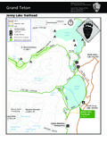
1 Wawona area Hiking MapYosemite National ParkNational park Department of the InteriorNorthChilnualna Falls6,200 ft / 1,890 mWawona Meadow4,012 ft / 1,223 m Mariposa Grove 6 mi / km one waySwinging Bridge km round trip6 mi / km one wayThe Redwoods in Yosemite (cabin rentals)to Alder CreekMosquito Creekto Alder CreekWawona RoadAlder FallWawona Dome6,899 ft / 2,103 mAlder CreekSouth EntrancePioneer YosemiteHistory Center41 Sierra National ForestTo Yosemite ValleyAlder Creek TrailWawona Meadow km round trip Forest DriveChilnualna Falls RoadWawona CampgroundTo FresnoMariposa Groveof Giant SequoiasMariposa GroveWelcome PlazaGrove ArrivalAreaGrizzly Giant Wawona Visitor Center at Hills StudioWawonaSierra National ForestSierra National ForestSee inset, above rightSee inset, on reverseLegendRoadsTrails your safety.
2 Always carry plenty of water and be prepared for changing conditions. This map should not be used for Wilderness trips. Please visit a park visitor center or wilderness center for more information. All overnight stays in Wilderness require a permit. KeyRestroomParkingParking for vehicles dis-playing a valid disabled placardGrove Shuttle StopYARTS Stop (Summer only)Picnic AreaLodgingGas StationGrocery StoreBooks and SouvenirsPost Office Stables Golf Course TrailTrail toAlder CreekAlder CreekTrailheadStoreGift ShopPost OfficeBig Trees LodgeTrail toMariposa Grove(6 miles)Pioneer YosemiteHistory CenterWawona Road (Hwy.)
3 41) Forest Drive Chilnualna Falls Road Wawona Visitor Center at Hill's StudioTo South Entrance & Mariposa Grove Meadow Loop TrailSouth Fork Merced River Covered BridgeStableCampground Reservation OfficeGolf ShopTo Chilnualna Falls Trailhead and The Redwoods in YosemiteTo Yosemite ValleyTo Swinging Bridge LoopWawona Wawona area Hiking MapYosemite National ParkNational park Department of the Interior Easy Wawona Meadow miles ( km) round trip to 2 hours Begin at the Big Trees LodgeWalk on the paved road across the Wawona Golf Course. Once across the golf course, take a left at the sign-posted trailhead.
4 The trail is an unpaved fire road which loops around the meadow and returns to the Wawona Road. A relaxing and scenic stroll, this trail offers views across Wawona Basin and opportunities to see wildlife and wildflow-ers. Horses, bikes, and leashed pets are allowed on the Trees Loop (easy) mile ( km) round trip30 to 45 minutes wheelchair accessible Begin at Mariposa Grove Arrival AreaWinding through a forest with many giant sequoias, this trail features the Fallen Monarch and interpretive panels on the life and ecology of giant sequoias. This loop is relatively flat and is wheelchair Giant Loop miles ( km) round trip to 2 hours500 feet (150 m) elevation gainBegin at Mariposa Grove Arrival past notable trees such as the Bachelor and Three Graces, the Grizzly Giant, and the California Tunnel Tree.
5 Visitors with a valid dis-aboled placard can drive as far as the Grizzly Giant parking and enjoy the grove via a section of trail that is wheelchair accessible. Moderate Swinging Bridge miles ( km) round trip2 to 3 hours1 mile round trip from end of Forest Drive 30 minutesBegin at Wawona Store / Pioneer Yosemite History Center parking area / or at the end of Forest Drive The paved road, Forest Drive, leads 2 miles ( km) upstream from the Pioneer Yosemite History Center to the Seventh Day Adventist Camp. At the camp, bear to the left onto the dirt road and continue 1/2 mile to the Swinging Bridge.
6 Cross the bridge and bear left onto the trail which becomes a dirt road and then Chilnualna Falls Road. This road will return to the Pioneer Yosemite History Center at the Wawona Stable. Cross the covered bridge to return to the parking area . Most of this trail is along roads. ALTERNATIVE: Drive the two miles to the end of Forest Drive and hike 1/2 mile one-way to Swinging Bridge. Strenuous Alder Creek8 miles ( km) round trip to Alder Creek. 6 hours(2,500 ft / 762 m elevation gain) Begin at Alder Creek Trailhead parking area ; located .4 miles up Chilnualna Falls Road The trail leads from the parking area across the road and heads uphill north through an open pine forest with abundant manzanita growing on drier slopes.
7 The trail provides access to Alder Fall, a little-visited, 100-foot cascade. Carry lots of drinking water in summer, whentemperatures can be extreme. ALTERNATE ROUTE: Begin at MosquitoCreek along Wawona Road (hike is 6 miles round-trip to Alder Fall). Strenuous Chilnualna miles (13 km) round trip 5 to 6 hours (2,400 ft / 732 m elevation gain) Begin at Chilnualna Falls Trailhead parking area located two miles up Chilnualna Falls Road The trail leads from the parking area across the road and along Chilnualna Creek for 1/2 mile (.8 km). A series of switchbacks lead away from the creek into the open forest.
8 The falls are comprised of five large cascades sliding through and over rock formations above the Wawona Basin water here is fullest in spring and early summer. Carry lots of drinking water in the summer, when temperatures can be Grove Trail to Wawona miles ( km) round trip3 to 5 hours1,200 feet (366 m) elevation gainBegin at Mariposa Grove Arrival AreaThis wide and relatively smooth trail follows a route that people have used to access the grove for generations. See famous sequoias such as the Bachelor and Three Graces, the Faithful Couple, and the Clothespin Tree along this somewhat strenuous route to the upper reaches of the grove.
9 Continue to historic Wawona Point, an over-look with panoramic Loop miles ( km)4-6 hours1,000 feet (300 m)Begin at Mariposa Grove Arrival AreaFrom the tranquil upper portion of the grove, a ( km) loop takes hikers past many unique features such as the fallen Wawona Tunnel Tree, the Telescope Tree, and the Mariposa Grove Grove AreaMap not to scaleLoop Trail Grizzly GiantLoopTrailROAD TO ACCESSIBLE PARKING Mariposa Grove Trail Mariposa Grove Trail Mariposa Grove Trail Perimeter Trail Perimeter Trail Big Trees Mariposa Grove RoadWashburn Trail* 2 mi ( km) Perimeter TrailPerimeter TrailGuardians LoopTrailWAWONA POINTM ariposa Grove CabinColumbia TreeMariposaTre eTelescopeTre eParking is allowed only when shuttle Service is not availableClothespinTre eFaithfulCoupleCaliforniaTunnelTre eGrizzlyGiantBachelor& mi ( km) mi ( km)5 mi (8 km) mi ( km) mi ( km) mi ( km) mi ( km)ELEV.
10 6,800 ft. (2,073 m)GROVEARRIVALAREAT railheadTO SIERRANATIONALFORESTTO SIERRANATIONALFORESTTO WAWONATO Wawona , GLACIER POINTAND YOSEMITE VALLEYLIMITED ACCESS: Road open ONLY to private vehicles which aredisplaying a valid disabled placard when the shuttle is AREAMARIPOSA GROVEWELCOME PLAZASOUTHENTRANCESTATIONELEV. 5,600 ft. (1,707 m)ELEV. 5,100 ft. (1,554 m)ELEV. 6,400 ft. (1,951 m)ELEV. 5,900 ft. (1,798 m) mi ( km) mi ( km) mi ( km) mi ( km) mi ( km) mi ( km) mi ( km) mi ( km) mi ( km) mi ( km) mi ( km) mi ( km) mi ( km) mi ( km) mi ( km) mi ( km) mi ( km) mi ( km) mi ( km) mi ( km) mi ( km) mi ( km) mi ( km) mi ( km) mi ( km) mi( km) mi ( km)TO FISH CAMPAND OAKHURSTP erimeter mi ( km) mi ( km)LIMITED ACCESS: Road open ONLY to private vehicles which are displaying a valid disabled placard when the shuttle is running.