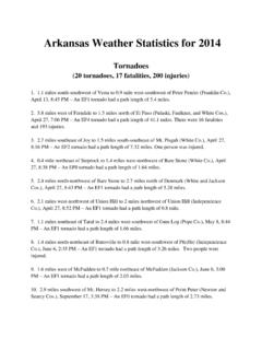
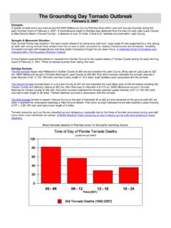
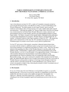
Transcription of WEATHER FORECAST OFFICE February 22, 2022 Weekly …
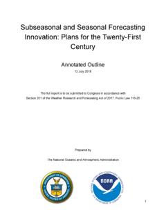
1 AlbuquerqueWEATHER FORECAST OFFICEW eekly WEATHER 16, 2022 Hermit s Peak WildfireMay 15, 2022 | View from El Prado/Taos, NMUsed with permission. Photo Courtesy of Kristina - Twitter: @elementalmamaBear Trap Wildfire | May 15, 2022 - 22 UTC or 4PM MDTGOES-18 Geocolor imageryAlbuquerqueWEATHER FORECAST OFFICEW eekly WEATHER Reports for Past WeekStationPrecipitation (in)Monument Albuquerque (NM-BR-292) ~2,600 reports of | Thank you!Valid: May 8 - 16, 2022 AlbuquerqueWEATHER FORECAST OFFICEW eekly WEATHER WEATHER Potential Today/TonightAlbuquerqueWEATHER FORECAST OFFICEW eekly WEATHER Impacts: Today and TonightAlbuquerqueWEATHER FORECAST OFFICEW eekly WEATHER Wind Outlook for Wildfires in Nrn MtnsAlbuquerqueWEATHER FORECAST OFFICEW eekly WEATHER Wind Outlook for Wildfires in Nrn MtnsAlbuquerqueWEATHER FORECAST OFFICEW eekly WEATHER and Precipitation Outlook Precipitation: Isolated to scattered storms for central & eastern NM this afternoon.
2 Small chances again Wednesday and possibly into the weekend. High Temps:Above to well above normal readings will be rule with record high temperatures. Cooler for the FORECAST OFFICEW eekly WEATHER and Potential ImpactsUpper Level FORECAST Chart Valid Midnight MTTonightSEVERE WEATHER POTENTIAL | DRY THUNDERSTORMS A couple of upper level disturbances will be moving across the area today and tonight. The first may support isolated to scattered storms. Storms will be ending 7-9PM this evening but could see dry thunderstorms along with wet storms with a damaging wind threat. Low temperatures will be on the mild side Winds will be light from the SW AlbuquerqueWEATHER FORECAST OFFICEW eekly WEATHER and Potential ImpactsTuesdayUpper Level FORECAST Chart Valid 3pm MTHEAT RISK SE NM | POOR AIR QUALITY Lighter westerly winds aloft will result on Tuesday behind the upper level disturbance and another system will be developing in the Great Basin.
3 High temperatures will be approaching records again with upper 90s in E NM with 80s/90s for the rest of the FORECAST OFFICEW eekly WEATHER and Potential ImpactsWednesdayUpper Level FORECAST Chart Valid 3pm MTISOLATED TO SCATTERED STORMS | ELEVATED FIRE DANGER Upper level disturbance moves into Arizona and may see a few showers/storms in northern NM. High temperatures will be lower than the previous couple of days but still above FORECAST OFFICEW eekly WEATHER and Potential ImpactsThursdayUpper Level FORECAST Chart Valid 3pm MT Upper level disturbance will swing through the state supporting dry and windy conditions with an increasing jet stream. High temperatures will be approaching records again with upper 90s in E NM with 80s/90s for the rest of the state. Winds will be increasing from the SW/W and single digit relative humidity will be likely again. Look for more Red Flag OF CRITICAL FIRE WEATHER & DANGEROUS FIRE SPREAD | BLOWING DUST & POOR AIR QUALITYA lbuquerqueWEATHER FORECAST OFFICEW eekly WEATHER and Potential ImpactsFridayUpper Level FORECAST Chart Valid 3pm MT Westerly winds aloft will continue with a storm system over the northern Rockies and Plains High temperatures continue to climb and remain above normal.
4 There should be a slight decrease in temperatures into the weekend with the storm system. Winds and low RH are still expected to be in line to monitor for Red Flag Warnings for parts of New FIRE WEATHER & DANGEROUS FIRE SPREAD | BLOWING DUST & POOR AIR QUALITYA lbuquerqueWEATHER FORECAST OFFICEW eekly WEATHER WeekendUpper Level FORECAST Chart Valid 6pm MTSaturdaySundayA series of upper level disturbances will move across New Mexico over the weekend. Northern mountains may get some precipitation but otherwise it will be dry yet again. Winds are not expected to be as strong as Thursday into Friday but a backdoor front may push into eastern and central NM Saturday night into FORECAST OFFICEW eekly WEATHER Day Temp/Precip Outlooks (Climate Prediction Center)AlbuquerqueWEATHER FORECAST OFFICEW eekly WEATHER (Common)Minor (Common)Moderate (Uncommon)High (Rare Event)Extreme (Very Rare Event)Potential Impacts Color TableImportant: WEATHER conditions and forecasts can change significantly in a short period of time.
5 Please stay up-to-date at product is for situational awareness and is intended to be used alongside more detailed FORECAST productsTonightTuesday, May 17 Wednesday, May 18 Thursday, May 19 Friday, May 20 Weekend Elevated fire danger due to breezy & dry conditions in western & central NMIsolated to scattered strong to severe t-storms from central mountain chain eastward with lightning, downburst winds & hailHot temperatures will increase risk of heat exhaustion & heat stroke, especially in east central to southeastern NMElevated fire danger due to breezy & dry conditionsGusty winds from showers producing little rainfall in northwestern & north central NMIsolated to scattered t-storms in northeastern NM with lightning, downburst winds & small hailElevated fire danger due to breezy & dry conditions in western & central NM Hot temperatures will increase risk of heat exhaustion & heat stroke, especially in east central to southeastern NMCritical fire WEATHER due to stronger winds & low humidityStrong crosswinds & areas of blowing dust possibleCritical fire WEATHER due to strong winds & low humidityStrong crosswinds & areas of blowing dust possibleCritical fire WEATHER due to strong winds & low humidityStrong crosswinds & areas of blowing dust possibleBackdoor cold front through E & C NM Saturday night into Sunday morning - gap windsWeek at a GlanceNote: Areas of smoke, potentially dense in nature, will be a concern through the entire FORECAST period | This will lead to poor air qualityAlbuquerqueWEATHER FORECAST OFFICEW eekly WEATHER from Wildfires | Ready, Set, GoPer NM Fire Information.
6 Scan the QR code for the latest evacuation map or visit the ArcGIS Map. It is imperative to respect closures and follow evacuation orders. Please follow San Miguel County and Mora County Sheriff s Facebook pages for the latest updates at: and