Transcription of WELCOME TO GHANA - accraexpat.com
1 WELCOME TO GHANA ! Here is some general information about you new host country THE FLAG THE COAT OF ARMS THE NATIONAL ANTHEM MAPS. DATA ON GHANA . INTRODUCTION GEOGRAPHY CLIMATE PEOPLE. EDUCATION HISTORY GHANA 'S PRESIDENTS. GOVERNMENT AND POLITICAL CONDITIONS ECONOMY. FOREIGN RELATIONS LINKS. The flag of GHANA The color Red commemorates those who died or worked for the country's independence ;. The color Gold was influenced by the mineral rich nature of GHANA lands ;. The color Green was chosen because GHANA lies in the tropics and is blessed with rich vegetation. Then the five pointed lone star which is the symbol of African emancipation and unity in the struggle against colonialism. The coat of arms The coat of arms of GHANA was introduced on 4 March 1957 by Elizabeth II. It shows a blue shield, which is divided into four parts by a St George's Cross with a golden edge. In the middle of the cross there is the golden lion of the United Kingdom of Great Britain and Northern Ireland.
2 This symbolizes the close relationship of GHANA to the Commonwealth and the Kingdom. The first part, on the upper left shows a sword, known as a okyeame, which is used at ceremonies. It is a symbol for the regional governments of GHANA , while the area to the right, which shows a representation of a castle on the sea, the presidential palace in Accra on the Gulf of Guinea, symbolizes the national government. The third part of the shield shows a cacao tree, which embodies the wealth of GHANA . The fourth and last field - on the lower right - shows a gold mine, which stands for the richness of natural resources in GHANA . Upon the shield there are beads with the national colors red, green, and gold, which the flag of GHANA also bears. Above that, there is a black five-pointed star with a golden border, symbol for the freedom of Africa. Holding the coat of arms are two golden eagles, which have black stars on a band of the national colors hanging around the neck.
3 They are perched on a motto ribbon, which bears the national motto of GHANA : FREEDOM AND JUSTICE. Independence Arch, in Accra bearing the motto "Freedom and Justice". National anthem: "Hail the name of GHANA ". God bless our homeland GHANA , And make our nation great and strong, Bold to defend forever The cause of Freedom and of Right. Fill our hearts with true humility Make us cherish fearless honesty, And help us to resist oppressors' rule With all our will and might evermore. Hail to thy name, O GHANA To thee we make our solemn vow;. Steadfast to build together A nation strong in Unity;. With our gifts of mind and strength of arm, Whether night or day, in the midst of storm, In every need whate'er the call may be, To serve thee, GHANA , now and evermore. Raise high the flag of GHANA , And one with Africa advance;. Black star of hope and honor, To all who thirst for liberty;. Where the banner of GHANA free flies, May the way to freedom truly lie Arise, arise, O sons of Ghanaland, And under God march on forevermore.
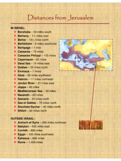
4 MAPS. Click to enlarge This map and many other GHANA maps may be downloaded here DATA ON GHANA . INTRODUCTION. In addition to the data below, the links at the bottom of this page will provide you with more information. For news about GHANA , see accraexpat's How to Guide's How to keep posted with GHANA news . OFFICIAL NAME: Republic of GHANA In Africa, GHANA ranks 24th by size out of 53 countries, 9th by population and 7th by population density. Well endowed with natural resources, GHANA has roughly twice the per capita output of the poorest countries in West Africa. Even so, GHANA remains heavily dependent on international financial and technical assistance and the domestic economy typically continues to revolve around agriculture, which accounts for about 43 percent of GDP and employs about 55 percent of the work force, mainly small landholders. GEOGRAPHY. Area: 238,538 sq. km. (92,100 sq. mi.); about the size of the , Uganda, Romania or Laos Cities: Capital--Accra (metropolitan area pop.)
5 3 million est.). Other cities--Kumasi (1. million est.), Tema (500,000 est.), Sekondi-Takoradi (370,000 est.). GHANA is located on West Africa's Gulf of Guinea only a few degrees north of the Equator and is bordered on the north by Burkina Faso, on the west by C te d'Ivoire, and on the east by Togo. The country lies just above the equator and is on the Greenwich meridian line which passes through the seaport of Tema, about 24. km to the east of Accra, the capital. Its southernmost coast at Cape Three Points is 4 30' north of the equator. From here, the country extends inland for some 670. kilometers. The distance across the widest part measures about 560 kilometers. Half of the country lies less than 152 meters (500 ft.) above sea level, and the highest point is 883 meters (2,900 ft.). The 537-kilometer (334-mi.) coastline is mostly a low, sandy shore backed by plains and scrub and intersected by several rivers and streams, most of which are navigable only by canoe.
6 A tropical rain forest belt, broken by heavily forested hills and many streams and rivers, extends northward from the shore, near the Cote d'Ivoire frontier. This area produces most of the country's cocoa, minerals, and timber. North of this belt, the country varies from 91 to 396 meters (300 ,300. ft.) above sea level and is covered by low bush, park-like savanna, and grassy plains. Volta Lake, the largest manmade lake in the world, extends from the Akosombo Dam in southeastern GHANA to the town of Yapei, 520 kilometers (325 mi.) to the north. The lake generates electricity, provides inland transportation, and is a potentially valuable resource for irrigation and fish farming. CLIMATE. The climate is tropical. The eastern coastal belt is warm and comparatively dry; the southwest corner, hot and humid; and the north, hot and dry. There are two distinct rainy seasons in the south; May-June and August-September; in the north, the rainy seasons tend to merge.
7 Annual rainfall in the coastal zone averages 83 centimeters (33 in.) and ranges from about 1,100 mm (about 43 in) in the north to about 2,100 mm (about 83 in) in the southeast. Southern GHANA is much wetter, has high temperatures all year round, and has a very short dry season. Lush forests and all kind of crops grow throughout the year. Farmers in the North struggle to grow anything during the long dry season. In most areas the highest temperatures occur in March, the lowest in August. The average annual temperature is about 26oC (about 79oF). The harmattan, a dry desert wind, blows from the northeast from December to March, lowering the humidity and creating hot days and cool nights in the north. In the south the effects of the harmattan are felt in January. PEOPLE. Population (2007 est.): 23 million. Density: 88/sq. km. (247/sq. mi.). Annual growth rate (2007 est.): Ethnic groups: Akan, Ewe, Ga, Moshi-Dagomba. Religions: Christian 69%, Muslim , traditional and indigenous beliefs Languages: English (official), Akan (which includes Asante Twi, Akwapim Twi, Akyem, and Fanti) 49%, Mole- Dagbani 16%, Ewe 13%, Ga-Adangbe 8%, Guan 4%, others 10%.
8 Education: Years compulsory--9. Health: Infant mortality rate (2003 est.)--64/1,000. Life yrs. for women, yrs. for men Work force ( million): Agriculture and ; industry and ; sales and ; ; ; GHANA 's population is concentrated along the coast and in the principal cities of Accra and Kumasi. Most Ghanaians descended from migrating tribes that probably came down the Volta River valley at the beginning of the 13th century. Ethnically, GHANA is divided into small groups speaking more than 50 languages and dialects. Among the more important linguistic groups are the Akans, which include the Fantis along the coast and the Ashantis in the forest region north of the coast; the Guans, on the plains of the Volta River;. the Ga- and Ewe-speaking peoples of the south and southeast; and the Moshi-Dagomba-speaking tribes of the northern and upper regions. English, the official and commercial language, is taught in all the schools. EDUCATION. Primary and junior secondary school education is tuition-free and mandatory.
9 The Government of GHANA 's support for basic education is unequivocal. Article 39 of the constitution mandates the major tenets of the free, compulsory, universal basic education (FCUBE) initiative. Launched in 1996, it is one of the most ambitious pre-tertiary education programs in West Africa. Since the early 1980s, Government of GHANA expenditures on education have risen from to nearly of GDP. Since 1987, the share of basic education in total education spending has averaged around 67%. The units of the Ministry of Education, Science and Sports (MOESS) responsible for education are: the GHANA Education Service (GES), which administers pre-university education; the National Council on Tertiary Education; the National Accreditation Board; and the National Board for Professional and Technician Examinations (NABPTEX). The West African Examinations Council (WAEC), a consortium of five Anglophone West African Countries ( GHANA , Nigeria, Sierra Leone, Gambia, and Liberia) is responsible for developing, administering, and grading school-leaving examinations at the secondary level.
10 Since 1986, pre-tertiary education in GHANA includes six years of primary education, three years at the junior secondary school level and three years at the senior secondary school level. A new educational reform, beginning September 1, 2007, has introduced two years of kindergarten education beginning at age four and increased the three years senior secondary to four years. Successful completion of senior secondary school leads to admission eligibility at training colleges, polytechnics, and universities. In 2006. there were approximately million students attending schools at these three levels: 68% at the primary level, 23% at the junior secondary level and 10% at the senior secondary level. There are over six hundred public senior secondary schools in GHANA that graduated a total of 90,000 students in 2004, representing a huge expansion over the old system (which was transformed in 1987), which consisted of three hundred institutions graduating 27,000 students a year.