Example: bachelor of science
What is the Risk of Flooding from Surface Water Map?
The Risk of Flooding from Surface Water information assesses flooding scenarios as a result of rainfall with the following chance of occurring in any given year 3.3 % (1 in 30) ... reduction of effective rainfall through taking account of drainage and infiltration a better digital terrain model that incorporated the Environment Agency’s
Tags:
Information
Domain:
Source:
Link to this page:
Documents from same domain

Social Security and Child Support SSCS1
assets.publishing.service.gov.ukPage 1 Social Security and Child Support Notice of appeal against a decision of the Department for Work and Pensions You should use this form to appeal against a decision made by the Department for Work and Pensions (DWP) about social

The Midlands Engine for Growth - …
assets.publishing.service.gov.ukThe Midlands Engine for Growth This prospectus brings the Midlands Engine for Growthto life. It signals willingness from all regional stakeholders to

Applying for a passport from outside the UK
assets.publishing.service.gov.uk1 Things you need to know Get it right • This guidance is for British applicants from certain countries applying for a passport from outside the UK, using the OS application …

Outdoor advertisements and signs: a guide for …
assets.publishing.service.gov.ukOutdoor advertisements and signs:a guide for advertisers Advertisement control This booklet, prepared by Communities and Local Government, aims to explain to everyone who wants to display an outdoor advertisement how

Department of Health Review: Final Report
assets.publishing.service.gov.ukMental Health, Disability and Equality Department of Health Room 313A Richmond House 79 Whitehall SW1A 2NS

The quality of clinical coding in the NHS
assets.publishing.service.gov.ukFor the past seven years the Payment by Results data assurance framework has provided assurance over the quality of the data that underpin payments in the NHS.

The constitution of governing bodies of maintained …
assets.publishing.service.gov.ukThe constitution of governing bodies of maintained schools . Statutory guidance for governing bodies of maintained schools and local authorities in England

UNITED KINGDOM ANTI-CORRUPTION STRATEGY …
assets.publishing.service.gov.ukfinancial centre 35 3.3 romote integrity across the public and private sectors P 42 3.4 educe corruption in public procurement and grants R 48

Contract Management : The Commercial Role
assets.publishing.service.gov.ukContract Management is a team activity involving project, finance and commercial staff. However, this CPS is created as definitive policy on the role of

ESF Guidance on Document Retention
assets.publishing.service.gov.uk1 england european social fund operational programme 2014-20 guidance on document retention, including electronic data exchange, for 2014-20 esf projects
Related documents

Crown & Cross-Slope - Pennsylvania State University
www.dirtandgravel.psu.edusurface and softens the road. Or, drainage is forced to travel on the road surface causing erosion, loss of road material, and an increased need for maintenance. ... Pavement resists infiltration of water and will shed water more quickly than an unpaved surface. The cross -slope of a paved road is typically 2%, or ¼” of fall

DESIGN OF STORM WATER DETENTION POND - Asian …
www.adb.orglonger time to flow through the grass or earth surface and infiltration. Moreover, the detention pond provides flood storage, and offset the increase in runoff due to urbanization. The ... The storm water drainage network is designed for a one in two-year return period in compliance with the design guidelines and practices in the PRC.

National Standards for sustainable drainage systems
assets.publishing.service.gov.ukA4. Surface runoff that cannot be discharged into the ground or to a surface water body must be discharged to a surface water sewer or local highway drain, except where it can be demonstrated that it is not reasonably practicable to do so. Discharge to a combined sewer A5. Surface runoff that cannot be discharged into the ground, a surface ...
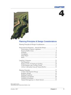
Planning Principles & Design Considerations - Indiana
www.in.govzone acts as a further setback between the waterbody and impervious surface areas. It provides more permeable surface area for infiltration of storm water runoff into the soil. The vegetation in this zone also helps convert concentrated storm water runoff into sheet flow, maximizing surface area for infiltration of runoff.
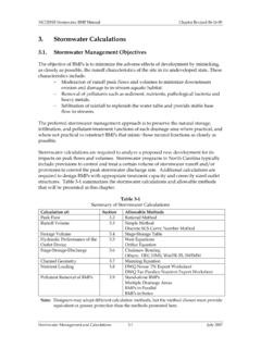
Stormwater Management Objectives - NC
files.nc.govJun 16, 2009 · − Infiltration of rainfall to replenish the water table and provide stable base flow to streams. The preferred stormwater management approach is to preserve the natural storage, infiltration, and pollutant-treatment functions of each drainage area where practical, and

Inherent Factors Affecting Soil Infiltration - USDA
www.nrcs.usda.govpractical to express the infiltration rate as the minutes needed for a soil to absorb each inch of water applied to the surface. If the rate is too slow, it can result in ponding in level areas, surface runoff, and erosion in sloping areas and can lead to flooding or …
Guidelines for the Design and Construction of Stormwater ...
www1.nyc.govdetermined by drainage plan and built sewers Increased onsite management of stormwater runoff through detention and retention Because runoff from smaller sites may not exceed 0.25 cfs, medium and large lots are more likely to be affected Incentives for green infrastructure, including recycling and infiltration systems