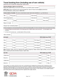
Transcription of Year 8 Geography Sample assessment | Investigating ...
1 141127 The State of Queensland (Queensland curriculum and assessment Authority) and its licensors 2014. All web links correct at time of publication. assessment description Category Students present findings and representations of data and information about landscapes and their landforms in a collection of work using a range of appropriate communication forms. Multimodal and written/spoken Technique Collection of work Context for assessment Alignment Students: develop a collection of work in class to demonstrate knowledge, understanding and skills about landscapes and landforms use a range of sources to complete a series of learning projects in class including.
2 A labelled sketch (from a photograph) of one landscape and specific landforms a special purpose map showing the distribution at a global scale of one type of landform with a description, including examples an annotated photograph (or sketch) of a landform model to explain the geomorphological processes evident a labelled diagram of a geomorphological hazard, a map showing the distribution of where this hazard occurs and an annotated map with a case study summary a n explanation of an artwork of a landscape or landform by an Aboriginal or Torres Strait Islander artist a graphical representation and analysis of a specific land degradation issue a factsheet with labelled map about one of Australia s natural World Heritage sites.
3 australian curriculum , Year 8 Geography australian curriculum content and achievement standard ACARA australian curriculum , assessment and Reporting Authority Year 8 Geography standard elaborations: Connections This assessment can be used with the QCAA australian curriculum resource titled Year 8 Geography year plan Geography exemplar available at: Definitions Landform: The individual surface features of the earth identified by their shape, dunes, plateaux, canyons, beaches, plains, rivers and valleys. Landscape: A landscape is the visible appearance of an area, created by a combination of geological, geomorphological, biological, cultural layers that have evolved over time, and as perceived, portrayed and valued by people.
4 A geomorphic landscape is the landscape without the biological and cultural layers. Geographical processes: The physical and human forces that work in combination to form and transform the world, erosion, the water cycle, migration or urbanisation. Geographical processes can operate within and between places. Spatial distribution: The arrangement of particular phenomena or activities across the surface of the Earth. Annotation: The process of adding comments and explanations to make meaning. In Geography , annotations are added to visual texts such as diagrams or maps. Geomorphology: A field of study which attempts to describe and understand the natural features of and australian curriculum Year 8 Geography Sample assessment Teacher guidelines Investigating landscapes and their landforms australian curriculum Year 8 Geography Investigating landscapes and their landforms Unit 1: Landforms and landscapes Teacher guidelines the processes operating on, the Earth s surface.
5 Landscape degradation: Degradation occurs through human actions and includes salinity, accelerated soil erosion, the spread of weeds, loss of biodiversity and habitats and water pollution. Geomorphological hazard: Hazards that originate from the lithosphere including volcanic eruptions, earthquakes, landslides and avalanches. Stack: A geological landform consisting of a steep and often vertical column or column of rock in the sea near a coast, formed by erosion. In this assessment Teacher guidelines Task -specific standards continua Task -specific standards matrix assessment resource 1: Identifying landscapes and their landforms assessment resource 2: Geomorphic processes in action assessment resource 3: Geomorphological hazards assessment resource 4: Connecting landforms to Country/Place assessment resource 5: Land degradation assessment resource 6: Protecting significant landscapes assessment resource 7: Glossary of geographical terms Student booklet australian curriculum Year 8 Geography Investigating landscapes and their landforms Unit 1.
6 Landforms and landscapes Teacher guidelines Teacher guidelines Identify curriculum Content descriptions to be taught Geographical Knowledge and Understanding Geographical Inquiry and Skills The different types of landscapes and their distinctive landform features (ACHGK048) The aesthetic, cultural and spiritual value of landscapes and landforms for people, including Aboriginal and Torres Strait Islander Peoples (ACHGK049) The geomorphic processes that produce landforms, including a case study of at least one landform (ACHGK050) The human causes and effects of landscape degradation (ACHGK051) The ways of protecting significant landscapes (ACHGK052) The causes, impacts and responses to a geomorphological hazard (ACHGK053) Collecting, recording, evaluating and representing Collect, select and record relevant geographical data and information, using ethical protocols, from appropriate primary and secondary sources (ACHGS056) Evaluate sources for their reliability and usefulness and represent d ata in a range of appropriate forms, for example, climate graphs, compound column graphs, population pyramids, tables, field sketches and annotated diagrams, with and without the use of digital and spatial technologies (ACHGS057)
7 Represent the spatial distribution of different types of geographical phenomena by constructing appropriate maps at different scales that conform to cartographic conventions, using spatial technologies as appropriate (ACHGS058) Interpreting, analysing and concluding Analyse geographical data and other information using qualitative and quantitative methods, and digital and spatial technologies as appropriate, to identify and propose explanations for spatial distributions, patterns and trends and infer relationships (ACHGS059) Apply geographical concepts to draw conclusions based on the analysis of the data and information collected (ACHGS060) Communicating Present findings, arguments and ideas in a range of communication forms selected to suit a particular audience and purpose, using geographical terminology and digital technologies as appropriate (ACHGS061) Reflecting and responding Reflect on their learning to propose individual and collective action in response to a contemporary geographical challenge, taking account of environmental, economic and social considerations, and predict the expected outcomes of their proposal (ACHGS062)
8 australian curriculum Year 8 Geography Investigating landscapes and their landforms Unit 1: Landforms and landscapes Teacher guidelines General capabilities (GCs) and cross- curriculum priorities (CCPs) This assessment may provide opportunities to engage with the following GCs and CCPs. Refer also to the Resources tab on the P 10 Geography curriculum and assessment page: Literacy Numeracy ICT capability Critical and creative thinking Personal and social capability Ethical understanding Intercultural understanding Aboriginal and Torres Strait Islander histories and cultures Asia and Australia s engagement with Asia Sustainability Achievement standard This assessment provides opportunities for students to demonstrate the following highlighted aspects.
9 By the end of Year 8, students explain geographical processes that influence the characteristics of places and explain how places are perceived and valued differently. They explain interconnections within environments and between people and places and explain how they change places and environments. They propose explanations for spatial distributions and patterns among phenomena and identify associations between distribution patterns. They compare alternative strategies to a geographical challenge and propose a response, taking into account environmental, economic and social factors. Students identify geographically significant questions from observations to frame an inquiry.
10 They locate relevant information from a range of primary and secondary sources to answer inquiry questions. They represent data and the location and distribution of geographical phenomena in a range of appropriate graphic forms, including maps at different scales that conform to cartographic conventions. They analyse geographical data and other information to propose explanations for spatial patterns, trends and relationships and draw reasoned conclusions. Students present findings, arguments and ideas using relevant geographical terminology and graphic representations in a range of appropriate communication forms. They propose action in response to a geographical challenge taking account of environmental, economic and social considerations and predict the outcomes of their proposal.