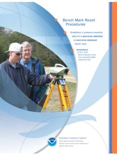
Bench Mark Reset Procedures
and Procedures to Incorporate Electronic Digital/Bar-Code Leveling Systems” for 3rd and higher order accuracy leveling procedures and equipment requirements. Record rod readings, at a minimum, to millimeters, or thou-sandths of feet. The model and type of instrument and rods used (e.g., fiberglass, aluminum, single piece, etc.), as well
Download Bench Mark Reset Procedures

Information
Domain:
Source:
Link to this page:
Documents from same domain

Chapter 4 Supersedes Chapter 2 GLOBAL NAVIGATION …
www.ngs.noaa.govJun 06, 2016 · Global Navigation Satellite System Data . Survey Equipment Data . Control Point Data . Accuracy Data . Within these categories, the data have been grouped into one or more logical units called "records." A record is a string of characters containing data coded according to a specific format. Every record in a GNSS B-file consists of

NOAA Manages the National Spatial Reference System
www.ngs.noaa.govNational Spatial Reference System ... n Global Navigation Satellite System (GNSS) orbits; n orientation, scale, and offset information relating NAD 83 to international terrestrial reference systems; and n all necessary information to describe how these values change over time.

WORLD WAR II HISTORY OF THE DEPARTMENT OF …
www.ngs.noaa.govWORLD WAR II HISTORY OF THE DEPARTMENT OF COMMERCE . PART 5 US COAST AND GEODETIC SURVEY . UNITED STATES DEPARTMENT OF COMMERCE . CHARLES SAWYER, Secretary . COAST AND GEODETIC SURVEY . ROBERT F.A. STUDDS, Director . WORLD WAR II HISTORY . Of the . ... the installation of high-precision machine-tool equipment in war plants. …

Survey Monument Preservation - National Geodetic Survey
www.ngs.noaa.govResearch existing monuments and scout their condition. Select route to pass through, or install new, monuments. Install new monuments and take precise measurements.

Trimble Survey Controller User Guide
www.ngs.noaa.govSurvey Controller software: 6021376, 6016118, 5986604, 5969708, 5831573, 5614913 and other patents pending. Release Notice This is the July 2001 release (Revision A) of the Survey Controller User Guide, part number 44011-00-ENG. It applies to version 10.0 of the Trimble Survey Controller™ software. The following limited warranties give you ...

State Plane Coordinate System of 1983
www.ngs.noaa.govThe State Plane Coordinate System of 1927 was designed in the 1930s by the U.S. Coast and Geodetic Survey (predecessor of the National Ocean Service) to enable surveyors, mappers, and engineers to connect their land or engineering surveys to a common reference system, the North American Datum of 1927. The following
DETERMINATION OF LOOK ANGLES TO GEOSTATIONARY ...
www.ngs.noaa.govFrom Fig. 1 it is clear that the azimuth c,' of the satellite is a function of the angle f3. In this particular situation, as can be seen in the Fig. 1, eL' = 180 ~ _ 13. The angle 13 is computed using Napier's rules as 13 = cos-l(cot "y tan +') (6) Consequently, once the vertex angle 13 at P' is known, the value of the ...

Trimble R7/R8 GPS Receiver User Guide
www.ngs.noaa.govBluetooth wireless radio is far below the FCC radio frequency exposure limits. Nevertheless, the wireless radio shall be used in such a manner that this receiver is 2.0cm or further from the human body. The internal wireless radio operates within guidelines found in radio frequency safety standards and recommendations, which reflect the

Datums, Heights and Geodesy
www.ngs.noaa.govEach equipotential surface has one distinct potential quantity along its surface. Point on earth’s surface is the level surface parallel to the geoid achieved by adding or subtracting potential. Lines don’t appear parallel; they are based on the gravity field and are …
The DSDATA Format
www.ngs.noaa.govDec 15, 2020 · AD9914 COUNTRY - CANADA Data Item USGS Quadrangle When Displayed Always, but may be blank Comments This is the name of the USGS 7.5 minute series map sheet which shows the area of the mark. The mark may or may not appear as a map feature. NGS sometimes publishes data according to the USGS quadrangle (quad) system, for which the
Related documents
Chapter 7 SAMPLING PROCEDURES IN RESEARCH
educad.meSAMPLING PROCEDURES IN RESEARCH Researchers must answer many questions when developing a project to collect information about a population of interest. Consider the following questions involving sampling: • Should we take a census (complete canvas) or a sample? • What kind of sample should be taken? • What size should the sample be?

Physics Experiments in Mechanics - Houston Community …
learning.hccs.eduThe x-intercept of a line is that point on the abscissa, or x-axis, at which a line crosses that axis. The y-intercept is defined in the same manner. 1.4.2 GRAPHING: EXERCISE. You are to graph the following three sets of data and have them checked by your instructor. 1.
Zero-Inflated Negative Binomial Regression
ncss-wpengine.netdna-ssl.comNote that k is the number of predictors including the intercept. Residuals As in any regression analysis, a complete residual analysis should be employed. This involves plotting the residuals against various other quantities such as the regressor variables (to check for outliers and curvature) and the response variable. Raw Residual
FIELD SAMPLING AND TESTING MANUAL TESTING …
www.dot.nd.gov3/13/2019 Revised Procedures Page 2 of 2 ND T 217 Determination of Moisture in Soils by Means of a Calcium Carbide Gas . Pressure Moisture Tester (Speedy) ... The receptacle should be of sufficient size to intercept the entire stream and hold the material without overflowing.