Example: dental hygienist
Survey Monument Preservation - National Geodetic Survey
Research existing monuments and scout their condition. Select route to pass through, or install new, monuments. Install new monuments and take precise measurements.
Tags:
Information
Domain:
Source:
Link to this page:
Documents from same domain

Chapter 4 Supersedes Chapter 2 GLOBAL NAVIGATION …
www.ngs.noaa.govJun 06, 2016 · Global Navigation Satellite System Data . Survey Equipment Data . Control Point Data . Accuracy Data . Within these categories, the data have been grouped into one or more logical units called "records." A record is a string of characters containing data coded according to a specific format. Every record in a GNSS B-file consists of

NOAA Manages the National Spatial Reference System
www.ngs.noaa.govNational Spatial Reference System ... n Global Navigation Satellite System (GNSS) orbits; n orientation, scale, and offset information relating NAD 83 to international terrestrial reference systems; and n all necessary information to describe how these values change over time.

WORLD WAR II HISTORY OF THE DEPARTMENT OF …
www.ngs.noaa.govWORLD WAR II HISTORY OF THE DEPARTMENT OF COMMERCE . PART 5 US COAST AND GEODETIC SURVEY . UNITED STATES DEPARTMENT OF COMMERCE . CHARLES SAWYER, Secretary . COAST AND GEODETIC SURVEY . ROBERT F.A. STUDDS, Director . WORLD WAR II HISTORY . Of the . ... the installation of high-precision machine-tool equipment in war plants. …

Trimble Survey Controller User Guide
www.ngs.noaa.govSurvey Controller software: 6021376, 6016118, 5986604, 5969708, 5831573, 5614913 and other patents pending. Release Notice This is the July 2001 release (Revision A) of the Survey Controller User Guide, part number 44011-00-ENG. It applies to version 10.0 of the Trimble Survey Controller™ software. The following limited warranties give you ...

State Plane Coordinate System of 1983
www.ngs.noaa.govThe State Plane Coordinate System of 1927 was designed in the 1930s by the U.S. Coast and Geodetic Survey (predecessor of the National Ocean Service) to enable surveyors, mappers, and engineers to connect their land or engineering surveys to a common reference system, the North American Datum of 1927. The following
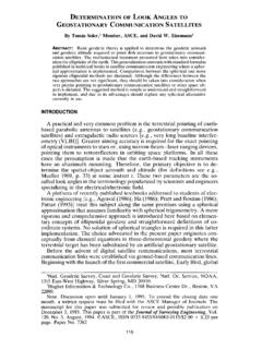
DETERMINATION OF LOOK ANGLES TO GEOSTATIONARY ...
www.ngs.noaa.govFrom Fig. 1 it is clear that the azimuth c,' of the satellite is a function of the angle f3. In this particular situation, as can be seen in the Fig. 1, eL' = 180 ~ _ 13. The angle 13 is computed using Napier's rules as 13 = cos-l(cot "y tan +') (6) Consequently, once the vertex angle 13 at P' is known, the value of the ...

Trimble R7/R8 GPS Receiver User Guide
www.ngs.noaa.govBluetooth wireless radio is far below the FCC radio frequency exposure limits. Nevertheless, the wireless radio shall be used in such a manner that this receiver is 2.0cm or further from the human body. The internal wireless radio operates within guidelines found in radio frequency safety standards and recommendations, which reflect the

Datums, Heights and Geodesy
www.ngs.noaa.govEach equipotential surface has one distinct potential quantity along its surface. Point on earth’s surface is the level surface parallel to the geoid achieved by adding or subtracting potential. Lines don’t appear parallel; they are based on the gravity field and are …
The DSDATA Format
www.ngs.noaa.govDec 15, 2020 · AD9914 COUNTRY - CANADA Data Item USGS Quadrangle When Displayed Always, but may be blank Comments This is the name of the USGS 7.5 minute series map sheet which shows the area of the mark. The mark may or may not appear as a map feature. NGS sometimes publishes data according to the USGS quadrangle (quad) system, for which the

2022 is Coming – Will You Be Ready? (or NAD83 and NAVD88 ...
www.ngs.noaa.gov• NAD83 frame ≠ GPS navigation frame • NAD83 frame ≠ WAAS navigation frame • NAD83 frame ≠ satellite orbits frame • NAD83 frame ≠ satellite product frame • NAD83 frame ≠ international geodetic frame – International flights take off & land on different datums – Many geodetic tools assume ITRF as default
Related documents
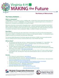
The History of Monuments The History Behind it
ext.vt.edumonuments is the Statue of Liberty, dedicated in 1886, as a symbol of freedom and democracy. World War I Many monuments and m emorials were constructed in communities across the …

THE ANCIENT MONUMENTS AND ARCHAEOLOGICAL SITES …
www.prsindia.orgTHE ANCIENT MONUMENTS AND ARCHAEOLOGICAL SITES AND REMAINS (AMENDMENT AND VALIDATION) ACT, 2010 [Act No. 10 of 2010] [29th March, 2010] An Act further to amend the Ancient Monuments and Archaeological Sites and Remains Act, 1958 and to
ANTIQUITIES, MONUMENTS AND MUSEUM REGULATIONS, …
www.lynettelockhart.comMonuments and Museum Act, 1998 to [state name and address], subject to the conditions, if any, set out below, to [ state approved operations ] within the area of [ state name and location ] as described

The West Less Traveled: The Best And Lesser Known Parks ...
www.thelifeenthusiastic.comThe Best and Lesser Known Parks, Monuments, and Natural Areas , then you've come to right site. We have The West Less Traveled: The Best and Lesser Known Parks, Monuments, and Natural Areas ePub, PDF, DjVu, doc, txt formats. We will be glad if you return to us anew.
BELMONT HOLDING, LLC v. DAVIS MONUMENTS, LLC AND …
courts.ms.govCounty against Davis Monuments, LLC, and Jason Davis, individually. The case proceeded to trial. The county court denied the replevin and entered a final judgment. Aggrieved by. the county court’s final judgment, Belmont filed a notice of appeal within thirty days of the
National Monuments and the Antiquities Act
fas.orgThe Antiquities Act of 1906 authorizes the President to proclaim national monuments on federal lands that contain historic landmarks, historic and prehistoric structures, or other objects of historic or scientific interest.
Chapter 16 Monumentation and Survey Records
www.wsdot.wa.govChapter 16 Monumentation and Survey Records 16-01 Monumentation and Survey Records The placement of markers or monuments in the ground is used for a variety of purposes.
History and Heritage, Memory and Memorialization ...
bergen.edumonuments and symbols should remain, be reinterpreted, or be removed. But also reflect upon the larger questions about how we understand history and heritage, what it means to have historical memory, and whether memory is different from memorialization.
Wisconsin Platting Manual - DOA Home
doa.wi.govequivalent) monuments be set at all Certified Survey Map (CSM) lot corners. You have proposed using a “P.K. nail” in lieu of the standard monument at the NE corner of lot 2, as the corner falls on concrete pavement as indicated on the
Record of Survey and Control Monument Data
www.hsr.ca.gov(2) Final Record to be added via addendum. (3) Construction Package 1, Survey Control Monument Data and Tie Sheetswithin County of Madera to be added via addendum .