
Chapter 6 Survey Datums
Highway Surveying Manual Page 6-1 January 2005 Chapter 6 Survey Datums 6-01 General Today’s multiorganizational Project Development efforts require the use of common,
Download Chapter 6 Survey Datums

Information
Domain:
Source:
Link to this page:
Documents from same domain

Chapter 6 Seismic Design
www.wsdot.wa.govChapter 6 Seismic Design 6.1 Seismic Design Responsibility and Policy 6.1.1 Responsibility of the Geotechnical Designer The geotechnical designer is responsible for providing geotechnical/seismic input

Project Management Manual - wsdot.wa.gov
www.wsdot.wa.govCommunication Management Plan [Output/Input] The document that describes: the communications needs and expectations for the project; how and in what format information will be

Project Risk Management Guide
www.wsdot.wa.govProject Management Online Guide in the Risk Management Plan spreadsheet. Larger, more complex projects may wish to use more robust analysis techniques via Monte Carlo simulation models.
Chapter 6 Storm Drains - Washington State …
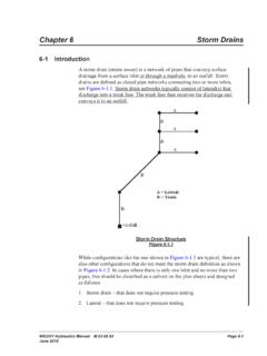
www.wsdot.wa.govWSDOT Hydraulics Manual M 23-03.03 Page 6-1 June 2010 Chapter 6 Storm Drains 6-1 Introduction A storm drain (storm sewer) is a network of pipes that conveys surface

Cost Estimating Manual for Projects
www.wsdot.wa.govWSDOT Cost Estimating Manual for Projects M 3034.03 Page i April 2015 Foreword WSDOT’s vision is to be the best at providing a sustainable and
Maintenance Manual - Washington State …
www.wsdot.wa.govForeword Reliable, well-maintained highway transportation facilities are essential to the well being of the state, its citizens, and its commerce.
Chapter 4 Soil and Rock Classification and Logging
www.wsdot.wa.govChapter 4 Soil and Rock Classification and Logging 4.1 Overview The detailed description and classification of soil and rock are an essential part of the

Chapter 1310 Intersections
www.wsdot.wa.govIntersections Chapter 1310 Page 1310-2 WSDOT Design Manual M 22-01.14 July 2017 1310.02 Design Considerations Consider all potential …
Chapter 25 Right of Way - Washington State …
www.wsdot.wa.govRight of Way Chapter 25 Page 25-2 WSDOT Local Agency Guidelines M 36-63.36 June 2018.11 WSDOT Services – At the earliest possible date, the local agency should notify
Chapter 1510 Pedestrian Facilities
www.wsdot.wa.govWSDOT Design Manual M 22-01.10 Page 1510-1 July 2013 Chapter 1510 Pedestrian Facilities 1510.01 General. 1510.02 References. 1510.03 Definitions
Related documents
An introduction to energy consumption in pumps - …
csmres.co.uk30 www.worldpumps.com WORLD PUMPS January 2008 If we set the efficiency of the transmission and the electric drive at 90%, then the power taken from the grid is 3.7/0.9 = ca. 4 …
Precision Digital Level Accuracy and Reliability - Digi ...
www.digipas.comInnovation & Technology Driven™ © 2017 DIGIPAS TECHNOLOGIES INC. All Rights Reserved. Precision Digital Level Accuracy and Reliability - Digi-Pas® 2-Axis Technology

Explanatory Notes on Geodetic Datums in Hong Kong 1995 ...
www.geodetic.gov.hkA3 Due to different definitions of the two datums, the geodetic positions (i.e. latitude and longitude) and the UTM co-ordinates of a point will be slightly different.
Concept of the New Japanese Geodetic System - GSI
www.gsi.go.jp1. Introduction - Geodetic Reference System - A geodetic reference system is defined as a total of the datums for representing a position on the earth and the

World Geodetic System 1984
www.unoosa.orgof the reference frame station coordinates. The 7-parameter transformation from WGS 84 (G1674) to ITRF2008 is zero in all components. This is by design since WGS 84 (G1674)