
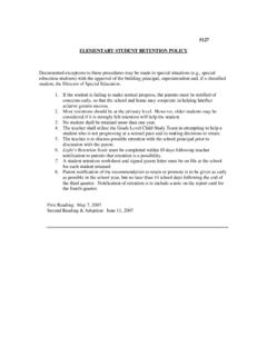
Climate Multiple Choice
locations on opposite sides of the mountain. ... A through D on the map below show the general paths of abandoned ... 51° 30' north latitude and 0° longitude. Elmira, New York, is located at approximately 42° 10' north latitude and 76° 54' west longitude.
Download Climate Multiple Choice

Information
Domain:
Source:
Link to this page:
Documents from same domain
ELEMENTARY STUDENT RETENTION POLICY
www.hcs.stier.org5127 . ELEMENTARY STUDENT RETENTION POLICY. Documented exceptions to these procedures may be made in special situations (e.g., special education students) with the approval of the building principal, superintendent and, if a classified

Not Your Grandma s Book Report - Harpursville …
www.hcs.stier.orgResponse Projects and Requirements 1. Design and make your own t-shirt. Illustrate a scene or character from the book on a t-shirt. Write a short summary of the scene and explain why it is important to the story.

Weathering, Erosion and Deposition Multiple Hjhkhjkhk Choice
www.hcs.stier.orgoutcropping fell because clouds had obscured the area Thursday and Friday; a state park trail crew discovered the collapse Saturday morning. The famous mountain’s history dates millions of years. Over time, nature carved out a 40-foot-tall profile resembling an old man’s face, and it eventually became New Hampshire’s most recognizable symbol.
The cross section below shows a rock sequence Which event ...
www.hcs.stier.orgThe Devonian coral fossil, Pleurodictyum, has approximately 400 growth rings between each yearly ridge, which suggests that there were about 400 days in a year during the Devonian Period. Supporting this hypothesis, scientists have found coral from the
Related documents

Map Scales - USGS
pubs.usgs.govat this scale cover 7.5 minutes of latitude and 7.5 minutes of longitude; they are commonly called "7.5-minute quadrangle" maps. Map coverage for the United States has been completed at this scale, except for Puerto Rico, which is mapped at 1:20,000 and 1:30,000, and a few States that have been For more information contact any
Unit Plan: Third Grade Geography and Explorers
emilybrittportfolio.weebly.comContent to be covered includes geography terms such as latitude, longitude, and cardinal directions; ... o Recognize the locations of Quebec, Canada, San Salvador in the Bahamas, St. Augustine, Florida, and ... Legends usually show a small picture of each of the symbols used on the map, along with a ...

INTRODUCTION: BASIC GEOGRAPHIC CONCEPTS
ses.wsu.eduA degree of latitude is approximately 69 miles, and a minute of latitude is approximately 1.15 miles. A second of latitude is approximately 0.02 miles, or just over 100 feet. A degree of longitude varies in size. At the equator, it is approximately 69 miles, the same size as a degree of latitude. The size gradually decreases to zero as the ...
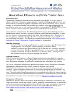
Geographical Influences on Climate - Teacher Guide
gpm.nasa.govStudents will compare the climatograms for different locations around the United States to observe patterns in temperature and precipitation. They will describe geographical features near those locations, and compare graphs to find patterns in the effect of mountains, oceans, elevation, latitude, etc. on temperature and precipitation.

Seasons Question Document Name: Date - MBHS EARTH …
mbhsearthscience.weebly.comAt which latitude is the observer located? A. the Equator (0 ) B. 231 2 N C. 661 2 N D. 90 N 27. Base your answer(s) to the following question(s) on the diagram below, which represents the position of the Sun with respect to Earth’s surface at solar noon on certain dates. The latitudes of six locations on the same line of longitude are shown.

Maps and Globes - Mrs. Wecker's Classroom
mrswecker.weebly.comIn Summary ~ Latitude and Longitude Latitude Lines of latitude are also called parallels. Parallels are equal distances apart from the equator to the poles. The equator is zero degrees latitude while the North and South Poles are 90 degrees latitude. Latitude is measured in degrees north and degrees south. Longitude

How to Display Coordinates as Points in ArcMap
libraries.mit.eduI can’t see my latitude and longitude columns when I select Add XY Data… Your columns are probably saved as text, rather than number. See the section above on Preparing the Data Table. My points don’t show up in the correct locations. You may have switched latitude and longitude values. Run Add XY Data again and use the other columns.
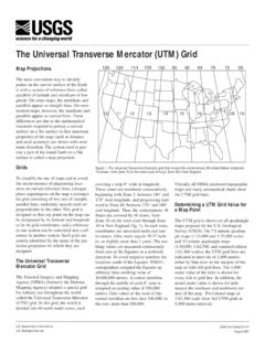
The Universal Transverse Mercator (UTM) Grid
pubs.usgs.govcovering a strip 6° wide in longitude. These zones are numbered consecutively beginning with Zone 1, between 180° and 174° west longitude, and progressing east-ward to Zone 60, between 174° and 180° east longitude. Thus, the conterminous 48 States are covered by 10 zones, from Zone 10 on the west coast through Zone 19 in New England (fig. 1).

Displaying Latitude and Longitude Data Adding XY Data in ...
sites.tufts.eduNov 10, 2015 · If you have a table of data that has longitude and latitude, or XY coordinates, you can view these data as points on a map in ArcMap. Examples might be school locations, data from a GPS receiver, or a table of violent conflicts. For detailed instructions about adding tabular XY data to ArcMap 10.2.2, see the ArcGIS Desktop Help for Adding XY