N5 - SQA
Study the Ordnance Survey Map Extract (Item A) of the Brecon Beacons area and find the cross-section X–Y shown on Diagram Q3 above. Use the information in the OS map to match the letters A to C with the correct features, choosing from the features below. • Afon Mellte (river) • A4059 • Minor road • Coniferous woodland 3
Download N5 - SQA

Information
Domain:
Source:
Link to this page:
Documents from same domain
Coursework for external assessment - SQA
www.sqa.org.ukSession 2017-2018 English templates – National 5, Higher and Advanced Higher Please use the following templates for English. A flyleaf, which we will issue to centres in
Develop and maintain a healthy, safe and secure ...
www.sqa.org.ukSKAPW7 - FT4P 04 Develop and maintain a healthy, safe and secure environment for children SKAPW7 Develop and maintain a healthy, safe and secure environment for children 1
FD3H 04 (CFAMLD1) Develop Productive Working …
www.sqa.org.ukFD3H 04 (CFAMLD1) Develop Productive Working Relationships with Colleagues 3 FD3H 04 (CFAMLD1) Develop Productive Working Relationships with Colleagues
LANCS29 Identify the presence of pests, diseases …
www.sqa.org.ukLANCS29 Identify the presence of pests, diseases and disorders-(SQA Unit Code-H2RD 04) Knowledge and understanding You need to know and understand:
Assessment Arrangements Explained: Information …
www.sqa.org.ukContents Assessment Arrangements Explained: Information for centres 1 Contents 1 Introduction 1 Access to assessment: the principles 3 Assessment arrangements: contacting SQA 5
Correspondences between UK and Irish frameworks …
www.sqa.org.ukQualifications can Cross Boundaries A guide to comparing qualifications in the UK and Ireland How to use this leaflet: This leaflet provides information that allows you to look at the ways qualifications are organised in the UK and Ireland.
H5S0 04 (SCDHSC0035) Promote the Safeguarding …
www.sqa.org.ukH5S0 04 (SCDHSC0035) — Promote the Safeguarding of Individuals 3 Relationships may include those developed over a period of time or those established in a situation where immediate care or support is required.
National Quali cations SPECIMEN ONLY
www.sqa.org.ukPage three Spanky: Yeh, you have a word with him kiddo . . . I’m sure he’ll appreciate it. Now for the last time, are you going to shut that folder or . . .
H5LD 04 (SCDHSC0032) Promote Health, Safety and …
www.sqa.org.ukH5LD 04 (SCDHSC0032) — Promote Health, Safety and Security in the Work Setting 1 H5LD 04 (SCDHSC0032) — Promote Health, Safety and Security in the Work Setting Overview This standard identifies the requirements when you …
F9D7 04 (ESKWP2): Word Processing Software 2 - …
www.sqa.org.ukF9D7 04 (ESKWP2): Word Processing Software 2 2 Evidence Requirements Completion of a portfolio (manual, electronic or combination) to cover all of the Skills and
Related documents
Geography programmes of study: key stages 1 and 2
assets.publishing.service.gov.ukuse maps, atlases, globes and digital/computer mapping to locate countries and describe features studied use the eight points of a compass, four and six-figure grid references, symbols and key (including the use of Ordnance Survey maps) to build their knowledge of the United Kingdom and the wider world
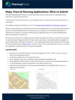
Maps, Plans & Planning Applications: What to Submit - A ...
ecab.planningportal.co.ukMaps, Plans & Planning Applications: What to Submit . Most planning applications require a location plan and a site plan (also known as a block plan), to be submitted as supporting documents. A location plan shows the proposal in its surrounding context and a site plan shows the development in more detail. 1
ORDNANCE SURVEY MAP READING
getoutside.ordnancesurvey.co.ukOrdnance Survey maps are covered in a series of faint blue lines that make up a grid. The lines have numbers accompanying them that allow you to accurately pinpoint your location on a map. Once you have located where you are, the grid system makes it simple to give others (such as Mountain Rescue) an accurate description of your location.

OS Landranger (1:50 000 scale) Map symbols
www.geographypods.comway are not shown on maps of Scotland. The representation on this map of any other road, track or path is no evidence of the existence of a right of way Firing and Test Ranges in the area. Danger! ... Made, printed and published by Ordnance Survey, Southampton, United Kingdom. For educational use only.
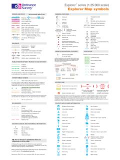
Explorer Explorer Map symbols - GEOGRAPHY FOR 2020 & …
www.geographypods.comGround survey height Air survey height 52 284 Surface heights are to the nearest metre above mean sea level. Heights shown close to a triangulation pillar refer to the ground level height at the pillar and not necessarily at the summit HEIGHTS AND NATURAL FEATURES Mud 60 75 50 Loose rock Outcrop Vertical face/cliff Boulders Scree TOURIST AND ...

BEST PRACTICE GUIDANCE FOR HABITAT SURVEY AND …
www.heritagecouncil.ieTO HABITAT SURVEY AND MAPPING 1 INTRODUCTION 2 1.1 Scope 2 1.2 Need for Best Practice Guidance 3 1.3 Habitat Survey Methodology 4 2 HABITAT CLASSIFICATION 6 2.1 Past Approaches to Classification 6 2.2 Habitats Directive 8 2.3 Current and Future Irish Systems 9 3 MAPS AND GIS 12 3.1 Overview 12 3.2 Introduction to Mapping 12

Soil Survey Bulletin No.
www.teagasc.iethe Geological Survey of Ireland. The scale of 1 : 30,000 compared very favourably with the map scale 1 : 25,000 used by the National Soil Survey (base maps only). Peatland distribution for Northern Ireland was derived from the Peat Bog Survey of Northern Ireland (1956), Land Use Survey Maps (1939), the 1920 Peat Map, and from