
OBJECT-BASED CLASSIFICATION VS. PIXEL-BASED …
The International Archives of the Photogrammetry, Remote Sensing and Spatial Information Sciences, Vol. XXXVIII-4/C7 OBJECT-BASED CLASSIFICATION VS.
Download OBJECT-BASED CLASSIFICATION VS. PIXEL-BASED …

Information
Domain:
Source:
Link to this page:
Documents from same domain
GUIDELINES FOR AUTHORS PREPARING …
www.isprs.orgguidelines for authors preparing manuscripts for publication in the isprs archives and the isprs annals . m. o. altan 1, g. toz 1, i. dowman 2, s. kulur 1, d. z. seker 1, p. löwe 3 c. heipke 4,

THERMAL REMOTE SENSING: CONCEPTS, ISSUES …
www.isprs.orgInternational Archives of Photogrammetry and Remote Sensing. Vol. XXXIII, Part B1. Amsterdam 2000. 239 THERMAL REMOTE SENSING: CONCEPTS, ISSUES AND APPLICATIONS

What is Remote Sensing?
www.isprs.org2 What is Remote Sensing ? “Remote Sensing is defined as the science and technology by which characteristics of objects of interest can …

Introduction to GIS (Basics, Data, Analysis) Case …
www.isprs.org1 Introduction to GIS (Basics, Data, Analysis) & Case Studies 13th May 2004 Content • Introduction to GIS • Data concepts • Data input • Analysis • …

HIGH (SPATIAL) RESOLUTION vs. LOW …
www.isprs.orgMahavir, Dr International Archives of Photogrammetry and Remote Sensing. Vol. XXXIII, Supplement B7. Amsterdam 2000. 127 HIGH (SPATIAL) RESOLUTION vs. LOW RESOLUTION IMAGES :
SOIL EROSION MODELLING BY USING GIS & …
www.isprs.orgSOIL EROSION MODELLING BY USING GIS & REMOTE SENSING : A CASE STUDY, GANOS MOUNTAIN Berk Ustun a, ∗* a ITU, Civil Engineering Faculty, 80626 Maslak Istanbul, Turkey-(e0727619@student.tuwien.ac.at) KEY WORDS: Environment, GIS, Hazards, Land Cover, Prediction, Vegetation, Monitoring ABSTRACT: This paper …
COMPETENCY STANDARDS - A MEASURE OF THE …
www.isprs.orgCOMPETENCY STANDARDS - A MEASURE OF THE QUALITY OF A WORKFORCE John C Trinder School of Surveying and SIS, The University of New South Wales, UNSW SYDNEY NSW 2052, Australia
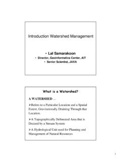
Introduction Watershed Management
www.isprs.org1 Introduction Watershed Management • Lal Samarakoon • Director, Geoinformatics Center, AIT • Senior Scientist, JAXA A WATERSHED … ¾Refers to a …
THE ACCURACY OF USING THEODOLITE IN CLOSE …
www.isprs.orgTHE ACCURACY OF USING THEODOLITE IN CLOSE-RANGE ENGINEERING MEASUREMENTS Hüseyin Gazi BAŞ University of Sakarya Engineering Faculty Department of Civil Engineering

LIDAR- DATA: AUTOMATIC OBJECT DETECTION …
www.isprs.orgLIDAR- DATA: AUTOMATIC OBJECT DETECTION TO SUPPORT URBAN FLOODING SIMULATION MD. Aktaruzzaman, Theo G. Schmitt Institute of Urban Water Management, University of Kaiserslautern, Paul Ehrlich strasse 14,
Related documents

VGA video signal generation - Biorobotics
lslwww.epfl.chEduardo Sanchez Page 5 Ecole Polytechnique Fédérale de Lausanne The vertical sync signal tells the monitor to start displaying a new image or framme, and the monitor starts in the upper left corner
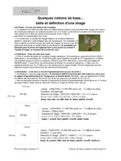
Quelques notions de base taille et définition d'une image
pixel-dargent-74.frQu'est-ce que la résolution d'un appareil photo numérique "La résolution se caractérise par le nombre de pixels par unité de longueur, c'est en fait la densité de pixel de l'image.

declaração de utilidade turística
www.consulpixel.ptE 3 declaração de utilidade turística1 Os empreendimentos declarados de Utilidade Turística (UT) gozam, essencialmente, das isenções da Sisa (actual IMT) e, durante sete anos, da Contribuição Autárquica

Factory Automation/Machine Vision- Fixed Focal- 1.5 Mega ...
www.fujifilmusa.comTitle: Factory Automation/Machine Vision- Fixed Focal- 1.5 Mega-Pixel 2/3" 1/2" Author: Fujifilm Created Date: 4/5/2011 9:39:02 AM

社外取締役の辞任について(補足)
www.pixela.co.jp平成27年7月23日 . 各 位. 株式会社ピクセラ. 取締役 池本 敬太. 社外取締役の辞任について(補足) 昨日公表いたしました「社外取締役の辞任に関するお知らせ」の記載内容について、
新4K衛星放送対応セットトップボックスの受注に関するお知 …
www.pixela.co.jp1 平成30年6月28日 各 位 会社名 株 式 会 社 ピ ク セ ラ 代表者名 代表取締役社長 藤 岡 浩 (コード番号 6731 東証第二部)

Models for wetland planning, design and management
www.pixelrauschen.de94 Models for wetland planning, design and management 1 Introduction The societal respect for wetlands has recently changed from former view of vast and wet lands,

LG Electronics, Inc. Display Limited Warranty - USA
www.lg.comElectronics, Inc. LG Electronics, Inc. Display Limited Warranty – Canada Your LG Display will be repaired or replaced in accordance with the terms of this warranty, at LGE’s option,