
PHOTOGRAMMETRY - CPP
quality photography. Aerial photographs taken with a frame camera are commonly classified as either vertical or oblique. Vertical photographs having a 9-inch by 9-inch format are the most common type taken for photogrammetric work. Basically, there are two types of aerial cameras presently used for photogrammetric mapping. They are: 1.
Download PHOTOGRAMMETRY - CPP

Information
Domain:
Source:
Link to this page:
Documents from same domain
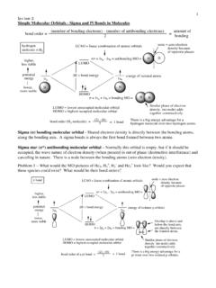
1 Lecture 2 Simple Molecular Orbitals - Sigma and …
www.cpp.edu1 Lecture 2 Simple Molecular Orbitals - Sigma and Pi Bonds in Molecules bond order = (number of bonding electrons) - (number of antibonding elect rons)
COLLEGE OF EDUCATION & INTEGRATIVE STUDIES …
www.cpp.eduCOLLEGE OF EDUCATION & INTEGRATIVE STUDIES CREDENTIAL SERVICES OFFICE 3801 West Temple Avenue, Pomona, CA …

Packing Checklist - California State Polytechnic ...
www.cpp.eduTraveler’s Name Departure Date Destination Days Local Weather travel essentials toiletries Clothes men women Basics Dressy Casual Outerwear & Accessories
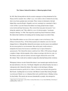
The Chinese Cultural Revolution: A …
www.cpp.edu1 The Chinese Cultural Revolution: A Historiographical Study In 1965, Mao Zedong believed that his socialist campaign was being threatened by Liu
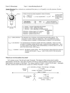
Chem 201/Beauchamp Topic 1: …
www.cpp.eduChem 201/Beauchamp Topic 1: Atoms,Bonding,Dipoles,IP 2 Effective nuclear charge - Zeffective is the net positive charge felt by the valence electrons (bonding and lone pair electrons). It can be estimated by subtracting the number of …
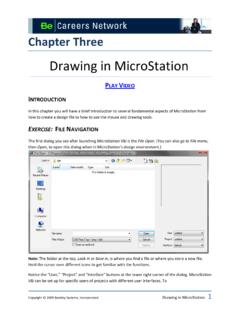
Drawing in MicroStation - California State …
www.cpp.eduon grid points (every inch) or to a keypoint on an object . To snap to a keypoint, the reset and data buttons are pressed simultaneously. A large cursor will appear
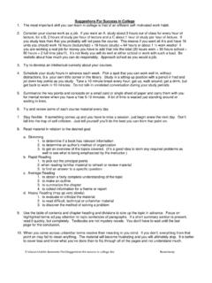
Suggestions for success in college - Cal Poly Pomona
www.cpp.eduZ:\classes\Adobe document files\Suggestions for success in college.doc Beauchamp e. Review your notes carefully within one day. f. You might leave 1/3 (vertical) of each note page blank to fill in later with any extra details you want to add.
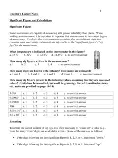
Chapter 1 Lecture Notes Significant Figures and …
www.cpp.edu2 • If the digit following the last significant figure is a 5 (with no other non-zero digits after the 5), round down if the last sig fig is even and round up if the last sig fig is odd. The rule about "5’s" is necessary to avoid statistical bias in your calculations. Statistically
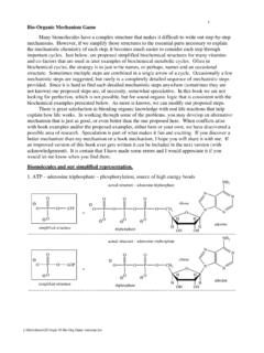
Bio-Organic Mechanism Game - Cal Poly Pomona
www.cpp.edu1 y:\files\classes\201\topic 10 Bio-Org Game reactions.doc Bio-Organic Mechanism Game Many biomolecules have a complex structure that makes it …
spice - Cal Poly Pomona
www.cpp.edu220-spice-notes.tex Page 3 The Circuit Description A circuit description in spice, which is frequently called a netlist, consists of a statement defining each circuit element. Connections are described by naming nodes.
Related documents

Remote Sensing and Geographical Information System (GIS)
ags.geography.du.ac.inthe first aerial photograph was taken from an aero plane, piloted by Wilbur Write over Centocelli, Italy. World War I provided a boost in the use of aerial photography. During that time, aerial photographs were used for two purposes – spying and mapping. Phase II (1920-1945): Development of Platforms and Sensors
LECTURE NOTES ON REMOTE SENSING & GIS
www.gpcet.ac.inAerial photography: It is the taking of photographs of the ground from an elevated/direct-down position. Usually the camera is not supported by a ground-based structure. Terrestrial photogrammetric: In this kind of photogrammetry, a camera is used in a stationary position. The camera is positioned on an elevated level.

ATP 3-11.74 CHEMICAL, BIOLOGICAL, RADIOLOGICAL, AND ...
armypubs.army.milATP 3-11.74 CHEMICAL, BIOLOGICAL, RADIOLOGICAL, AND NUCLEAR PLATOONS APRIL 2021 DISTRIBUTION RESTRICTION: Approved for public release; distribution is unlimited. Headquarters, Department of the Army

Geometry of Aerial Photographs* - GIS-Lab
gis-lab.infoAerial photo projects for all mapping and most image analyses require that a series of exposures be made along each of the multiple flight lines. To guarantee stereoscopic coverage throughout the site, the photographs must overlap in two directions: in the line of flight and between adjacent flights. 6.3.1 Endlap
3.4 Crime Scene Documentation and Forensic Photography
mymission.lamission.edu(1) note taking, (2) videography, (3) photography, and (4) sketching. All four are neces-sary and none is an adequate substitute for another; for example, notes are not sub - stitutes for photography and video is not a substitute for sketching. Each tool must be applied when and where needed to give as complete a record as possible.

Geography 11 Study Guide 26-6-2012 - Via Afrika
viaafrika.com1 The use of aerial photography One of the most effective tools that the geographer can use for the interpretation of the landscape is the aerial photograph and orthophoto map. 2 Oblique and vertical aerial photographs Aerial photographs can be vertical, directly overhead or oblique which are taken at an angle.

Chapter 3 Surveying Equipment, Measurements and Errors
www.wsdot.wa.govties to aerial photography control points (targets), property corners, right of way, property controlling corners and secondary control traverses. All horizontal angles will be measured clockwise (angle right) from the backsight regardless of the size of the angle. Special Care Although total stations are ruggedly built, careless or rough use and