
TFL Base Map
Redbridge Havering Barking & Dagenham Greenwich Bexley Newham Waltham Forest Bromley Tower Hamlets Hackney Lewisham Croydon Merton …
Download TFL Base Map

Information
Domain:
Source:
Link to this page:
Documents from same domain
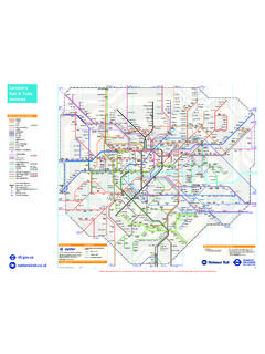
London’s 9ZONE ZONE8 9ZONE Rail & Tube …
content.tfl.gov.ukLondon’s Rail & Tube services tfl.gov.uk nationalrail.co.uk Online maps are strictly for personal use only. To license London’s Rail & Tube services map for commercial use please visit tfl.gov.uk/maplicensing
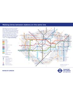
Wlin times between stations on te sme line
content.tfl.gov.ukTitle: Walking Tube Map Author: Transport for London Subject: Walking times between stations on the same line Created Date: 8/25/2016 10:28:48 AM
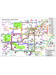
Key bus routes in central London - Transport for …
content.tfl.gov.ukRegent Street Piccadilly Circus St. James’s Park Victoria Victoria Street Westminster Belgrave Road Pimlico Grosvenor Road Victoria Coach Station Sloane Square Waterloo Elephant & Castle Kennington Road
You can find this map at tfl.gov.uk/maps and …
content.tfl.gov.ukRiver Thames Regent’s Park Goodge Street Bayswater Warren Street Aldgate Farringdon Barbican Russell Square High Street Kensington Old Street Green Park*
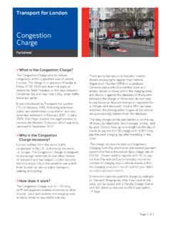
Congestion Charge factsheet - Transport for London
content.tfl.gov.ukTransport for London . Congestion Charge . Factsheet > What is the Congestion Charge? The Congestion Charge aims to reduce congestion within a specified area of central
DL Step-free Guide - Transport for London
content.tfl.gov.ukGrid Grid Grid C8 Abbey Road ¶ Â ß A D2 Acton Central r Step-free platform interchange requires a 50m journey via street. Use the East Churchfield
EOps Schedule 16 Exit Plan - Transport for London
content.tfl.gov.ukin each case so as to establish a detailed plan and management structure for all activities required for exit of the Service Provider under the specific conditions
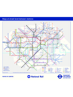
Steps at street level between stations - Transport for …
content.tfl.gov.uk2 2/3 3 2 2 2 2 1 3 2 3 3 3 1 1 3 3 River Thames City Thameslink Regent’s Park Goodge Street Bayswater Warren Street Aldgate Farringdon …
River Services Map April 2018 - Transport for London
content.tfl.gov.ukTitle: River Services Map April 2018 Author: Transport for London Subject: River Services map Created Date: 20180314155144Z
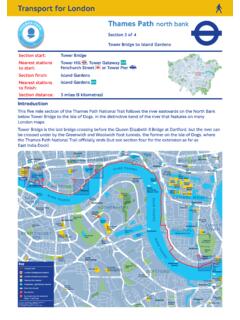
Thames Path north bank route ... - Transport for …
content.tfl.gov.ukTransport for London.. Thames Path north bank. Section 3 of 4. Tower Bridge to Island Gardens. Section distance: 5 miles (8 kilometres) . Introduction This five mile section of the Thames Path National Trail follows the river eastwards on the North Bank
Related documents

-VY[HJLYV - Fortacero
www.fortacero.com* También se manejan en grado A1011 CS 3Í405(73(*( +, 96336 Pulgada mm. PESOS POR PLACA EN KILOS 3/16 1/4 5/16 3/8 7/16 1/2 9/16 5/8 3/4 4.8 6.3 7.9 9.5 11.1 12.7

MAYFIELD - Integra Life
www.integralife.comA1011 A1008 A1073 A1112 A1072 A1083 A1084 A1047 A1048 A1109 A1110 A1023 MAYFIELD NeuroGen Adaptor MAYFIELD Spine Table Adaptor MAYFIELD Crossbar Adaptor MAYFIELD Universal Side Rail Fi ing MAYFIELD Ultra 360 Patient Positioning System MAYFIELD Ultra Base Unit MAYFIELD Swivel Adaptor MAYFIELD Tri-Star Swivel Adaptor MAYFIELD Ball Socket …

Lámina y Placa - Serviacero.com
www.serviacero.comNorma SAE 1008/1010, ASTM A1011, A568 Espesor Peso Calibre Pulg. mm. kg/m2 3´X 10´ 4´X 10´ ...