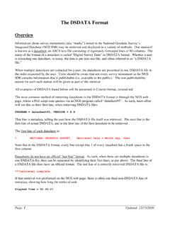
The DSDATA Format
Dec 15, 2020 · HV8128 FBN - This is a Federal Base Network Control Station. HV9260 CBN - This is a Cooperative Base Network Control Station. RF0849 PACS - This is a Primary Airport Control Station. RF0850 SACS - This is a Secondary Airport Control Station. DM9926 HT_MOD - This is a Height Modernization Survey Station.
Download The DSDATA Format

Information
Domain:
Source:
Link to this page:
Documents from same domain

Chapter 4 Supersedes Chapter 2 GLOBAL NAVIGATION …
www.ngs.noaa.govJun 06, 2016 · Global Navigation Satellite System Data . Survey Equipment Data . Control Point Data . Accuracy Data . Within these categories, the data have been grouped into one or more logical units called "records." A record is a string of characters containing data coded according to a specific format. Every record in a GNSS B-file consists of

NOAA Manages the National Spatial Reference System
www.ngs.noaa.govNational Spatial Reference System ... n Global Navigation Satellite System (GNSS) orbits; n orientation, scale, and offset information relating NAD 83 to international terrestrial reference systems; and n all necessary information to describe how these values change over time.

WORLD WAR II HISTORY OF THE DEPARTMENT OF …
www.ngs.noaa.govWORLD WAR II HISTORY OF THE DEPARTMENT OF COMMERCE . PART 5 US COAST AND GEODETIC SURVEY . UNITED STATES DEPARTMENT OF COMMERCE . CHARLES SAWYER, Secretary . COAST AND GEODETIC SURVEY . ROBERT F.A. STUDDS, Director . WORLD WAR II HISTORY . Of the . ... the installation of high-precision machine-tool equipment in war plants. …
Survey Monument Preservation - National Geodetic Survey
www.ngs.noaa.govResearch existing monuments and scout their condition. Select route to pass through, or install new, monuments. Install new monuments and take precise measurements.

Trimble Survey Controller User Guide
www.ngs.noaa.govSurvey Controller software: 6021376, 6016118, 5986604, 5969708, 5831573, 5614913 and other patents pending. Release Notice This is the July 2001 release (Revision A) of the Survey Controller User Guide, part number 44011-00-ENG. It applies to version 10.0 of the Trimble Survey Controller™ software. The following limited warranties give you ...

State Plane Coordinate System of 1983
www.ngs.noaa.govThe State Plane Coordinate System of 1927 was designed in the 1930s by the U.S. Coast and Geodetic Survey (predecessor of the National Ocean Service) to enable surveyors, mappers, and engineers to connect their land or engineering surveys to a common reference system, the North American Datum of 1927. The following
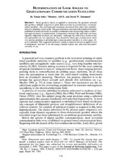
DETERMINATION OF LOOK ANGLES TO GEOSTATIONARY ...
www.ngs.noaa.govFrom Fig. 1 it is clear that the azimuth c,' of the satellite is a function of the angle f3. In this particular situation, as can be seen in the Fig. 1, eL' = 180 ~ _ 13. The angle 13 is computed using Napier's rules as 13 = cos-l(cot "y tan +') (6) Consequently, once the vertex angle 13 at P' is known, the value of the ...

Trimble R7/R8 GPS Receiver User Guide
www.ngs.noaa.govBluetooth wireless radio is far below the FCC radio frequency exposure limits. Nevertheless, the wireless radio shall be used in such a manner that this receiver is 2.0cm or further from the human body. The internal wireless radio operates within guidelines found in radio frequency safety standards and recommendations, which reflect the

Datums, Heights and Geodesy
www.ngs.noaa.govEach equipotential surface has one distinct potential quantity along its surface. Point on earth’s surface is the level surface parallel to the geoid achieved by adding or subtracting potential. Lines don’t appear parallel; they are based on the gravity field and are …

2022 is Coming – Will You Be Ready? (or NAD83 and NAVD88 ...
www.ngs.noaa.gov• NAD83 frame ≠ GPS navigation frame • NAD83 frame ≠ WAAS navigation frame • NAD83 frame ≠ satellite orbits frame • NAD83 frame ≠ satellite product frame • NAD83 frame ≠ international geodetic frame – International flights take off & land on different datums – Many geodetic tools assume ITRF as default
Related documents

Hardware Installation Guide - Access Control and Physical ...
accesscontrol.cornell.eduThe interchange of the AC NEUTRAL and SAFETY GROUND may result in ground current flowing through the power supply chassis and other ground paths, causing unreliable/improper system operation. The AC LINE input to Hardware power supplies is appropriately fused and switched. Local safety
MS-9200UDLS(E) Rev 3 - Fire Alarm Control Panels
www.firelite.comries, troubles, AC loss, etc.) to a Central Station via the public switched telephone network. It also allows remote and local programming of the control panel using the PS-Tools Upload/ Download utility. In addition, the control panel may be pro-grammed or interrogated off-site via the public switched tele-phone network.