
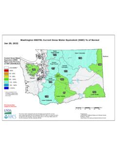
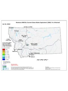
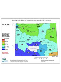
Westwide SNOTEL Current Snow Water Equivalent (SWE) % of ...
snow water equivalent found at selected SNOTEL sites in or near the basin compared to the average value for those sites on this day. Data based on the first reading of the day (typically 00:00). Created Date:
Download Westwide SNOTEL Current Snow Water Equivalent (SWE) % of ...
Information
Domain:
Source:
Link to this page:
Documents from same domain

Natural Resources Conservation Service Idaho …
www.wcc.nrcs.usda.govFor more water supply and resource management information: Contact: Your local county Natural Resources Conservation Service Office . Internet Web Address:
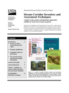
Stream Corridor Inventory and United States Assessment ...
www.wcc.nrcs.usda.govthe 1996 National Water Quality Inventory of 693,905 miles of rivers and streams, approximately 40 percent were impaired. Siltation, nutrients, and pathogens were the most common causes of degradation (U.S. EPA 1998) The need for stream corridor inventories and assessments

Watershed Science Institute - wcc.nrcs.usda.gov
www.wcc.nrcs.usda.gov3 Figure 1a. Common stonefly Plecoptera group.The common stonefly measures less than 1 inch in length (without tail), and has two wings, two sets of branched gills between

Chapter 2 Irrigation Water Requirements - USDA
www.wcc.nrcs.usda.govPart 623 National Engineering Handbook Chapter 2 Irrigation Water Requirements (210-vi-NEH, September 1993) 2–1 United States Department of Agriculture Soil Conservation Service Part …
Belingham 114 12 107 129 ^ 104 - USDA
www.wcc.nrcs.usda.govSeattle Yakima Spokane Everett Cle Elum Winthrop Wenatchee Belingham Walla Walla Marblemount PortAngeles Olympia Upper Columbia Lower Yakima Lower Columbia
111 116 97 104 108 - USDA
www.wcc.nrcs.usda.govHelena Butte Shelby Havre Bozeman Missoula Kalispell Great Falls Billings Jefferson Fl athe d Sun, Teton, Marias Upper Yellowstone Upper Clark Fork Smith, Judith,
115 94 45 - USDA
www.wcc.nrcs.usda.govCheyenne Sweetwater Laramie South Platte Tongue Madison - Gallatin Casper Laramie Rawlins Jackson Riverton Gillette Sheridan GREAT DIVIDE CLOSED BASIN Cheyenne

Idaho SNOTEL Current Snow Water Equivalent (SWE) % of ...
www.wcc.nrcs.usda.govTeton Big Wood Little Lost Little Wood Birch, Medicine Lodge, Beaver, Camas Salmon Fa ls Snake Basin above P ali sde Spokane 122 117 122 122 98 118 112 124 133 107 113 115 139 125 131 142 135 139 117 122 130 Idaho SNOTEL Current Snow Water Equivalent (SWE) % of Normal 0 10 20 40 60 80 100 Miles Provisional Data Subject to Revision Current Snow ...
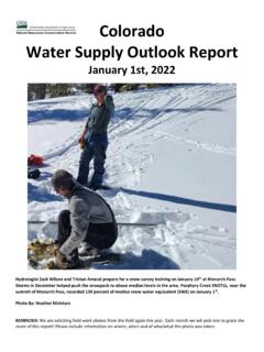
Colorado Water Supply Outlook Report
www.wcc.nrcs.usda.govJan 12, 2022 · The Colorado River basin reservoir storage is at 83 percent of median. The Upper Rio Grande River basin has 93 percent of median storage. Reservoir storage in the Gunnison River basin and combined San Miguel-Dolores-Animas-San Juan River basin remained below median at 56 and 64 percent of median, respectively,
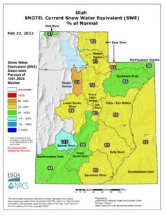
Utah SNOTEL Current Snow Water Equivalent (SWE) % of …
www.wcc.nrcs.usda.govThe snow water equivalent percent of normal represents the current snow water equivalent found at selected SNOTEL sites in or near the basin compared to the average value for those sites on this day. Data based on the first reading of the day (typically 00:00). San Pitch Upper
Related documents
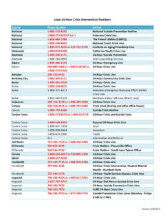
Local 24 Hour Crisis InterventionNumbers
archive.mhsoac.ca.gov24‐Hour Family Service Agency Grief Counseling Line; Marin 415‐499‐1100: 24‐Hour Family Service Crisis Telephone Counseling

Donner Summit Hwy 40 Scenic Bypass 20 Mile “inexpressibly ...
donnersummithistoricalsociety.orgBasin Indians, they were nomadic. The Washo traveled all over the Sierra, and used Donner Pass as a corridor for travel to and from Lake Tahoe. Adapted to life in the Great Basin and the Sierra, they made annual rounds hunting game, gathering and trading food, clothing materials, salt and ob-sidian.
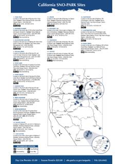
California SNO-PARK Sites
ohv.parks.ca.govsouth of Tahoe City. Contact: Lake Tahoe Basin Management Unit - (530) 543-2600. GPS: 39°6’50.77”N, 120°9’30.12”W. 4. TAYLOR CREEK . Located on the south side of Highway 89, just north of Camp Richardson Road. Contact: Lake Tahoe Basin Management Unit - (530) 543-2600. GPS: 38°55’56.95”N, 120°3’27.61”W. No. snowmobiling. 5 ...

SKI & BOARD SCHOOL TRAIL MAP
sugar3.sugarbowl.comDonner Lake, the Tahoe basin, alpine meadows, and the once-in-a-lifetime opportunity to get whisked away in a “just married” chair lift. Guests can stay at The Hotel at Sugar Bowl, steps away from the wedding venue, for an unforgettable weekend of memories. Visit .
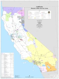
California Electric Utility Service Areas
ambitpros.comTahoe Vista Nevada City Kelseyville Point Arena Downieville Weaverville Laguna Beach Palm Springs Death Valley Moss Landing Independence Redwood City Markleeville ... Basin Airport Lake Leach Lake Superior Lake Deadman Lake Mesquite Lake West Cronese Lake Fort Irwin Pond Lost Lake Langford Well Lake Upper Lake Lower Lake Inyo Kern San Bernardino

Home | US Forest Service
www.fs.usda.govtahoe basin ween s nra lassen lincoln lolo los padres malheur manti-la sal twain bow-routt o modoc hela-mie mt. hood la a e-ter ocala ochoco n-ee olympic osceola ottawa ouachita ozark-is payette pike and el pisgah plumas t rio grande ver-siskiyou sabine salmon-challis sam houston. mckelvie san ino san juan santa fe h sequoia shawnee e sierra ...

Nevada’s Earthquake History - ShakeOut
www.shakeout.orgsettlements in Carson Valley and eastern Lake Tahoe. The earthquake occurred at about 2:40 in the morning. It began with a heavy rumbling sound and only lasted 3 to 10 seconds, but was strong enough to throw some people in Carson City to the ground. People immediately exited buildings in the sleeping garments in Carson City, Genoa, and Virginia ...
Electrical Conductivity/Salinity Fact Sheet
www.waterboards.ca.govLahontan (Region 6): The mean annual electrical conductivity of Lake Tahoe shall not exceed 95 umhos/cm at 50 degrees F at any location in the Lake. For other water bodies, there are objectives for conductivity or TDS. Colorado River Basin (Region 7): There are no objectives for conductivity. However,