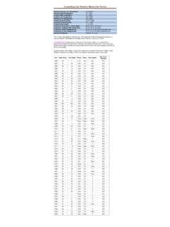
Transcription of Weather Map Symbols A B CC At the upper right is the
1 Along the center, the cloud types are indicated. The top symbol is the high-level cloud type followed by the mid-level cloud type. The lowest symbol represents low-level cloud over a number which tells the height of the base of that cloud (in hundreds of feet) In this example, the high level cloud is Cirrus, the mid-level cloud is Altocumulus and the low-level clouds is a cumulonimbus with a base height of 2000 CuDense CiDense As a/o NsCb no anvilDense Ci from CbAc; semi-transparentSc from CuCiinvadingskyAc StandingLenticularisCs below45 Ac invadingskySc NOTfrom CuCs above 45 ; notovercastAc from CuStOvercastCsAc withAs / NsStfra or CuFra ofbad weatherCs not ovcercast; not increasingAccongestusCu ans ScdifferentheightsCcAc ofchaotic skyCb w/anvilB123At the upper right is the atmospheric pressure reduced to mean sea level in millibars (mb) to the nearest tenth with the leading 9 or 10 omitted.
2 In this case the pressure would be mb. If the pressure was plotted as 024 it would be mb. When trying to determine whether to add a 9 or 10 use the number that will give you a value closest to 1000 number and symbol tell how much the pressure has changed (in tenths of millibars) in the past three hours and the trend in the change of the pressure during that same period. In this example, the pressure was steady then fell (lowered) becoming millibars LOWER than it was three hours lower than three hours agoRising, the falling Rising, then steady; or rising, then rising more slowlyRising steadily, or unsteadilyFalling or steady, then rising; or rising, then rising more quickly Steady, same as 3 hours ago Falling, then rising, same or lower than 3 hours ago Falling, then steady; or falling, then falling more slowly Falling steadily, or unsteadilySteady or rising, then falling; or falling, then falling more quicklyPressure higher than three hours agoGGThe circle symbol in the center represents the amount of total cloud cover reported in eighths.
3 This cloud cover includes all low, middle, and high level 4/8th5/8th6/8th7/8th8/8thSkyObscuredFThe lower right area is reserved for the past Weather , which is the most significant Weather that has occurred within the past six hours excluding the most recent or Few Clouds (not plotted)Partly cloudy (scattered) or variable sky (not plotted)Cloudy (broken) or overcast (not plotted)Sandstorm or dust storm, or drifting or blowing snowFog, or smoke, or thick dust hazeDrizzleRainSnow, or rain and snow mixed, or ice pellets (sleet)Shower(s)Thunderstorm, with or without precipitationI These lines indicate wind direction and speed rounded to the nearest 5 knots. The longest line, extending from the sky cover plot, points in the direction FROM which that wind is blowing. Thus, in this case, the wind is blowing FROM the southeast.
4 The shorter lines, called barbs, indicate the wind speed in knots (kt). The speed of the wind is determined by the barbs. Each long barb represents 10 kt with short barbs representing 5 kt. A pennant is used to represent each 50 kt. In this example, one short barb and one long barb means the wind speed is 15 Calm wind5 knots15 knots20 knots25 knots55 knotsDry Line - a boundary separating moist and dry air masses. It typically lies north-south across the central and southern high Plains states during the spring and early summer, where it separates moist air from the Gulf of Mexico (to the east) and dry desert air from the southwestern states (to the west). Squal Line - a line of active thunderstorms, either continuous or with breaks, including contiguous precipitation areas resulting from the existence of the Front - a zone separating two air masses, of which the cooler, denser mass is advancing and replacing the warmer.
5 Warm Front - a transition zone between a mass of warm air and the cold air it is replacing. Occluded Front - a composite of two fronts, formed as a cold front overtakes a warm or quasi-stationary front. Two types of occlusions can form depending on the relative coldness of the air behind the cold front to the air ahead of the warm or stationary front. A cold occlusion results when the coldest air is behind the cold front and a warm occlusion results when the coldest air is ahead of the warm Front - a front between warm and cold air masses that is moving very slowly or not at all. Trough - No temperature difference across boundaryNext to the visibility is the present Weather symbol. There 95 Symbols which represent the Weather that is either presently occurring or has ended within the previous hour. In this example, a light rain shower was occurring at the time of the Map Symbols779985-037120 ADBBEFHIBJ123 GCIn the upper left, the temperature is plotted in Fahrenheit.
6 In this example, the temperature is 77 F. On the second row, the far-left number is the visibility in miles. In this example, the visibility is five number at the lower left is the dew point temperature. The dew point temperature is the temperature the air would have to cool to become saturated, or in other words reach a relative humidity of 100%. Weather ServiceBuilding a Weather -Ready Nation0102030405060708091011120013142030 4050213141516061707180819091151617181922 2324252627282932333435363738394243444546 4748495253545556575859626364656667686972 7374757677787982838485868788899293949596 979899 Present Weather SymbolsRain shower(s), slightRain shower(s), moderate or heavyRain shower(s), violent Shower(s) of rain and snow mixed, slightShower(s) of rain and snow mixed, moderate or heavySnow shower(s), slightSnow shower(s), moderate or heavyShower(s) of snow pellets or small hail, slight with orwithout rain or rain/snowShower(s) of snow pellets or small hail, moderate or heavy w/ or w/o rain/snow Shower(s) of hail, slight,w/ or w/o rain or rain/snow mixed, no thunder Shower(s) of hail, w/ or w/o rain or rain/snow, no thunder, mod.
7 Or heavyThunderstorm during past hour w/ slight rain at time of observationThunderstorm during pasthour w/ current moderate/heavy rainThunderstorm ended w/ current slight snow, rain/snow mixed, or hailThunderstorm ended w/ current moderate/heavy snow, rain/snow, or hailThunderstorm, slight or moderate, w/o hail but w/rain and/or snowThunderstorm, slight or moderate, with hail at time of observationThunderstorm, heavy, w/o hail but with rain and/or snow Thunderstorm combined with dust storm or sandstormThunderstorm, heavy, with hail at time of observationIntermittent fall of snowflakes (slight at time of observation)Continuous fall of snowflakes (slight at time of observation)Intermittent fall of snowflakes (moderateat time of observation)Continuous fall of snowflakes (moderate at time of observation)Intermittent fall of snowflakes (heavy at time of observation)Continuous fall of snowflakes (heavy at time of observation)Ice needles (with or without fog)Snow grains (with or without fog)Isolated star-like snow crystals (with or without fog)Ice pellets (sleet)Rain, not freezing, intermittent (slight at time of observation)Rain, not freezing, continuous (slight at time of observation)Rain, not freezing, intermittent (moderate at time of observation)Rain, not freezing, continuous (moderate at time of observation)Rain, not freezing, intermittent (heavy at time of observation)Rain, not freezing, continuous (heavy at time of observation)Rain, freezing, slightRain, freezing,moderate or heavyRain or drizzle and snow, slightRain or drizzle and snow, moderate or heavyCloud development NOT observed during past hour (not plotted)
8 Clouds generally becoming less developed (not plotted)State of sky on the wholeunchanged during past hour (not plotted)Clouds generally forming or developing during past hour (not plotted)Visibility reduced by smokeHazeWidespread dust in the air, not raised by wind at or near stationDust or sand due to wind at or near the station but no dust whirl/sandstormWell developed dust whirland/or sand whirl but no dust storm/sandstormDust storm or sandstorm within sight or at the station during past hour( )( )Patches of shallow fog at station, NOT deeper than 6 feet on landMistMore or less continuous shallow fog at station, NOT deeper than 6 feetLighting visible, no thunder heardPrecipitation within sight, but NOT reaching the groundPrecipitation within sight, reaching the surface, but more than 3 miles awayPrecipitation within sight, reaching the surface within 3 milesThunder heard, but no precipitation at the stationSquall(s) within sight during past hourFunnel cloud(s) and/or Tornado(es) during the preceding hour)) (Drizzle (not freezing) or snow grains, not as shower(s), has endedRain (not freezing) not falling as shower(s) ,ended in the past hourSnow not falling as shower(s) ended in the past hourRain and snow or ice pellets, not as shower(s) ended in the past hourFreezing drizzle or freez- ing rain, not as shower(s)
9 Ended in the past hourShower(s) of rain endedin the past hourShower(s) of snow, or of rain and snow endedin the past hourShower(s) of hail, or of rain and hail ended in the past hourFog or ice fog endedin the past hourThunderstorm (with or without precipitation) ended in the past hourSlight or moderate dust storm or sandstorm (has decreased in past hour)Slight or moderate dust storm/sandstorm (no change during past hour)Slight or moderate dust storm or sandstorm (has begun or increased)Severe dust storm or sandstorm, decreased during the past hourSevere dust storm or sandstorm, has no change during past hourSevere dust storm or sandstorm has begun or increasedSlight or moderate drifting snow (generally below eye level)Heavy drifting snow (generally below eye level)Slight or moderate blowing snow (generally above eye level)Heavy blowing snow (generally above eyelevel)Fog at a distance, but not at the station during the preceding hourFog in patchesFog, sky visible (has become thinner during preceding hour)Fog, sky obscured (has become thinner during preceding hour)Fog, sky visible (no appreciable change during the past hour)Fog, sky obscured (no appreciable change during the past hour)Fog, sky visible (has begun or has become thicker during past hour)Fog, sky obscured (has begun or has become thicker during past hour)Fog, depositing rime ice, sky visibleFog, depositing rime ice, or ice fog, sky obscured)(Drizzle, not freezing, intermittent (slight at time of observation)Drizzle, not freezing, continuous (slight at time of observation)Drizzle, not freezing, intermittent (moderate at time of observation)
10 Drizzle, not freezing, continuous (moderate at time of observation)Drizzle, not freezing, intermittent (heavy at time of observation)Drizzle, not freezing, continuous (heavy at time of observation)Drizzle, freezing, slightDrizzle, freezing, moderate or heavyDrizzle and rain, slightDrizzle and rain, moderate or heavy Weather ServiceBuilding a Weather -Ready Natio