Transcription of 7: ERODIBLE SOILS - Franklin Township
1 Natural Resource Inventory (NRI). Franklin Township , Warren County, New Jersey 7: ERODIBLE SOILS . Erosion is defined as the natural process by which wind, moving water, ice, and gravitational forces displace the solid and particulate materials of the land. Erosion of solid materials, including exposed bedrock, occurs on an extended geological time scale. soil erodibility occurs on a much shorter time scale and with many more associated acute and chronic consequences. The determination of soil erodibility is a complex process that requires the consideration of soil type and texture. Clay and clayey SOILS are consistent (compacted, not loose), composed primarily of clay particles, and do not degrade rapidly under duress of erosional factors.
2 Loam SOILS consist of 7 to 27 % clay particles, 28 to 50% silt particles, and less than 52% sand particles in order of increasing grain sizes. Loamy SOILS are not as consistent due to the presence of larger particulate silt and sand. In addition to texture and type, erodibility is influenced by atmospheric conditions such as temperature and precipitation, stormwater runoff velocities, slope, and vegetative cover. Anthropogenic factors also influence erosion rates, chief among these being land use, which can exacerbate erosional problems or improve them through conservation practices. Erosional problems include declines in agricultural productivity, channelized flow, streambank instability, waterway sedimentation buildup, and contaminant transport.
3 The model with the greatest acceptance and use to predict soil erodibility is the Universal soil Loss Equation (USLE). USLE utilizes six different variables encompassing the influences discussed above to predict erodibility. The list of ERODIBLE SOILS within the Township of Franklin was obtained by the National Resource Conservation Service (NRCS). The NRCS has utilized the USLE, but modified it slightly to account for local conditions to produce erodibility codes for the SOILS of Warren County. The variables utilized are the following: Rainfall and Runoff Erosivity Factor, soil Erodibility Factor, Slope Length Factor, Slope Steepness Factor, Cover Management Factor, and Erosion Control Factor.
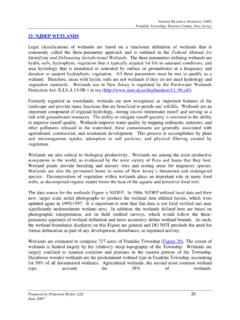
4 The corresponding Figure displays the results of the NRCS modified USLE displayed as three categories: Highly ERODIBLE Land (HEL), Potentially Highly ERODIBLE (PHE), Not Highly ERODIBLE (NHE) and Not Available (NA) (Figure 7). In general, the SOILS of Franklin Township are very susceptible to erosion. Highly ERODIBLE SOILS cover 46% of the Township , while Potentially Highly ERODIBLE SOILS are found throughout 45% of the Township . Not Highly ERODIBLE and undefined SOILS are found in just 9% of the Township area. Erosion within the Township is largely a function of slope and topography. HE SOILS are all located on slopes of at least 8%, all PHE SOILS are located on slopes between 0 and 15%, and NHE SOILS are located only on slopes less than 8%.
5 SOILS in the same series, such as the Parker SOILS , are differently affected by erosion according to slope. Erosion can be minimized by limiting development on steep slopes and maintaining vegetative cover. The adoption of best-management practices in compliance with existing state and local watershed and stormwater ordinances can also minimize the effects of sediment loading attributed to erosion. Prepared by Princeton Hydro, LLC 12. June 2007. Lopatcong Township File: P:\0420\Projects\0420006\GIS\MXD\ NEW JERSEY COUNTY MAP. Harmony Township White Township SUSSEX. PASSAIC. D R. MAN. RD. BERGEN. AN. MO N T.
6 YOL. A. ook a Br WARREN MORRIS. tan rook Mon ESSEX. B. Mill HUDSON. O K RD HUNTERDON. B RO. UNION. M IL L. R. E SOMERSET. RD. BIC. E. IV. KE. COL. MIDDLESEX. STE SECO. L. W RD ND S E RD. MICA MIN. RD. AR LE T. R. TS SVIL. V ILL WART. ER ST E. Greenwich Township D THIRD U SE RD MERCER. MONMOUTH. I SON RD. ST AY H O. RD. WI Poh S. M. RE. LLO at FW. ITE. W co orris Cana H AL. WH. A. ED. GR ng l (. OV. HE. E Cre MUL Dr y ek R. R. ). OCEAN. LE. LEM. LA. W. R LN. CLI. F F SI DE NEW E. D. AN. DR CAMDEN. ST BURLINGTON. RD. GLOUCESTER. D. SALEM. EN. A PE TRL. L. PRINCETON HYDRO, LLC. WA Y. 1108 OLD YORK ROAD, SUITE 1.
7 Atcong C e k RINGOES, NEW JERSEY, 08551. Poh DR. re RD. MO. WARNE. RR. RD. RFIELD. IS T. IS ON. DR. PK. WAY. E(. BROOK. RT. ED. PRICE DR 57. 0 1,500 3,000. OAD. COPPE. BRY ). D. MO. D. G O OD S PR I N G S RD AN. BR. Feet MAN R. WATER. UNT. R. AI N. RY- V IE. W. U. U. BEIDLE. ASB. 1 inch equals 3,000 feet RO. AD. MORG. AN. -W. RD HOFF. MAN. EST. RD SOURCES: 1. Parcel, roads and the Franklin Township Boundary data obtained from Warren County Planning Dept. "This map was developed using the Warren County New Jersey, Geographic Information System digital T data, but this secondary product has not been H ARLE Y C.
8 INSC. HO R. verified by Warren County and is not county- D DIR authorized.". T LN 2. Surface water data obtained from the NJDEP, E RD Division of GIS. I DG. K 3. SOILS data obtained from the USDA, Natural BR. M OU MI L Resource Conservation Service (NRCS) website. N T AI N VIEW RD TER. BUT. RD. KILN. Bloomsbury Boro RD. LER. LIME. Mus BUT. o netc BL O. O MSB. FIGURE 7. RD. o URY. R Washington Township c D. N. ERODIBLE SOILS . TO. ER. OLV. ng WO. R iv e r RD. NATURAL RESOURCE INVENTORY. HILL. Franklin Township . TERY. WARREN COUNTY, NEW JERSEY. E. CEM. KITC ANDERSO. HE N RD. NR. D S TEE PL. EC. ST. Legend HA.
9 IN. SE. MA. WI CKOFF CT. SUR. ERODIBLE SOILS MA H AL L. RY LN. RIDDLE CT. County Boundary Bethlehem Township P LE S M I L L RD. Municipal Boundaries AV. E. Highly ERODIBLE land Ponds/Lakes WARREN COUNTY. Streams RD. Potentially highly ERODIBLE land TS. IR. Streams SH. Not highly ERODIBLE land HUNT ERDO N CO Morris Canal (Dry). UN. Erosion potential unknown TY Roads Parcels Hampton Boro