Transcription of 9 S 6 8 5
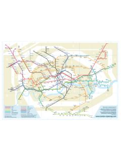
1 511155579S 3333333366444444466822222 123457689123457689 ABCDEFABCDEFN orthernPiccadillyVictoriaWaterloo and CityJubileeMetropolitanLondon OvergroundBakerlooCentralCircleCroydon Tram Link DistrictDocklands Light RailwayHammersmith and CityInterchange stations Croydon Tram Link, Heathrow Express and Watford Junction Station are subject to special fare rates outside of the zone system* London Overground Surrey Quays to Clapham Junction opens 2012 Interchange with network rail London Tubemap version map is a prototype, the information is correct to the best of our knowledge at the time of publication. It has no connection to Transport for London and does not represent the official depiction of the London Underground our website where you can let us know what you think about this map and your experiences of travelling on the underground system via our blog, twitter and facebook. Mark Noad 2011 Heathrow Express INDEX OF STATIONSGrid Line & ZoneC8 Abbey Road 3D2 Acton Central 3D2 Acton Town 3F7 Addington Village SF6 Addiscombe SC6 Aldgate 1C6 Aldgate East 1C7 All Saints 2C2 Alperton 4A1 Amersham 9F5 Ampere Way SF6 Anerley 4C6 Angel 1B5 Archway 2/3F7 Arena SA5 Arnos Grove 4B5 Arsenal 2F7 Avenue Road SC4 Baker Street 1E5 Balham 3C6 Bank 1C6 Barbican 1C9 Barking 4B9 Barkingside 4D3 Barons Court 2D4 Bayswater 1F7 Beckenham Junction SF7 Beckenham Road SC9 Beckton 3D9 Beckton Park 3C9 Becontree 5F5 Beddington Lane SF4 Belgrave Walk SB4 Belsize Park 2D6 Bermondsey 2C6 Bethnal Green 2F7 Birkbeck SD5 Blackfriars 1F6 Blackhorse Lane SB7 Blackhorse Road 3D8 Blackwall 2D5 Bond Street 1D6 Borough 1D2 Boston Manor 4A5 Bounds Green 3/4C7 Bow Church 2C7 Bow Road 2B4 Brent Cross 3E5 Brixton
2 2E7 Brockley 3C7 Bromley-by-Bow 2/3B3 Brondesbury 2 Grid Station Line & ZoneC3 Brondesbury Park 3A8 Buckhurst Hill 5A3 Burnt Oak 4A2 Bushey 8B5 Caledonian Road 2B5 Caledonian Road & Barnsbury 2B5 Camden Road 2C5 Camden Town 2D7 Canada Water 2D7 Canary Wharf 2D8 Canning Town 3D6 Cannon Street 1B6 Canonbury 2A3 Canons Park 5A2 Carpenders Park 7F6 Centrale SA1 Chalfont & Latimer 8B4 Chalk Farm 2C5 Chancery Lane 1D5 Charing Cross 1A1 Chesham 9A8 Chigwell 4D2 Chiswick Park 3A1 Chorleywood 7F6 Church Street SE5 Clapham Common 2E5 Clapham High Street* 2E4 Clapham Junction 2E5 Clapham North 2E5 Clapham South 2/3A5 Cockfosters 5A3 Colindale 3F4 Colliers Wood 3F7 Coombe Lane SD5 Covent Garden 1D7 Crossharbour 2B5 Crouch Hill 3A1 Croxley 7F6 Crystal Palace 2/3D8 Custom House 3E7 Cutty Sark 2/3D9 Cyprus 3B9 Dagenham East 5B9 Dagenham Heathway 5C6 Dalston Junction 2B6 Dalston Kingsland 2A8 Debden 6E6 Denmark Hill* 2E7 Deptford Bridge 2/3C7 Devons Road 2B3 Dollis Hill 3 Grid Station Line & ZoneF4 Dundonald Road SD2 Ealing Broadway 3D2 Ealing Common 3D4 Earl s Court 1/2C3 East Acton 2B1 Eastcote 5F6 East Croydon SA4 East Finchley 3C8 East Ham 3/4D8 East India 2/3E3 East Putney 2/3A3 Edgware 5C4 Edgware Road 1D6 Elephant & Castle 1/2F7 Elmers End SB9 Elm Park 6E7 Elverson Road 2/3D5 Embankment 1A9 Epping 6C5 Euston 1C5 Euston Square 1A9 Fairlop 4C6 Farringdon 1F7 Fieldway SA4 Finchley Central 4B4 Finchley Road 2B4 Finchley Road & Frognal 2B6 Finsbury Park 2E7 Forest Hill 3E3 Fulham BRoadway 2D9 Gallions Reach 3B8 Gants Hill 4F6 George Street SD4 Gloucester Road 1B4 Golders Green 3D3 Goldhawk Road 2C5 Goodge Street 1B4
3 Gospel Oak 2A9 Grange Hill 4F7 Gravel Hill SC5 Great Portland Street 1C1 Greenford 4E7 Greenwich 2/3D5 Green Park 1D2 Gunnersbury 3B6 Hackney Central 2C7 Hackney Wick 2C6 Haggerston 2A9 Hainault 4 Grid Station Line & ZoneD3 Hammersmith 2B4 Hampstead 2/3B4 Hampstead Heath 2C2 Hanger Lane 3C3 Harlesden 3B5 Harringay Green Lanes 3F7 Harrington Road SB2 Harrow & Wealdstone 5B2 Harrow-on-the Hill 5B1 Hatch End 6D1 Hatton Cross 5/6B2 Headstone Lane 5D1 Heathrow Terminals 1, 2, 3 6D1 Heathrow Terminal 4 6D1 Heathrow Terminal 5 6B4 Hendon Central 3/4D7 Heron Quays 2A4 High Barnet 5B5 Highbury & Islington 2B4 Highgate 3D4 High Street Kensington 1B1 Hillingdon 6C5 Holborn 1D3 Holland Park 2B5 Holloway Road 2B7 Homerton 2E7 Honor Oak Park 3B9 Hornchurch 6D2 Hounslow Central 4D2 Hounslow East 4D2 Hounslow West 5C6 Hoxton 1/2D4 Hyde Park Corner 1B1 Ickenham 6E4 Imperial Wharf 2D7 Island Gardens 2E5 Kennington 2C3 Kensal Green 2C3 Kensal Rise 2D3 Kensington (Olympia) 2B5 Kentish Town 2B5 Kentish Town West 2B2 Kenton 4E2 Kew Gardens 4B4 Kilburn 2C4 Kilburn High Road 2C4 Kilburn Park 2B3 Kingsbury 4C5 King s Cross St.
4 Pancras 1D9 King George V 3F7 King Henry s Drive SGrid Station Line & ZoneD4 Knightsbridge 1C3 Ladbroke Grove 2D6 Lambeth North 1D4 Lancaster Gate 1C7 Langdon Park 2D3 Latimer Road 2F6 Lebanon Road SD5 Leicester Square 1E7 Lewisham 2/3B8 Leyton 3B8 Leyton Midland Road 3B8 Leytonstone 3/4B8 Leytonstone High Road 3D7 Limehouse 2C6 Liverpool Street 1F6 Lloyd Park SD6 London Bridge 1D8 London City Airport 3A8 Loughton 6C4 Maida Vale 2B6 Manor House 2/3D6 Mansion House 1D4 Marble Arch 1C4 Marylebone 1F4 Merton Park SC7 Mile End 2A4 Mill Hill East 4F4 Mitcham SF5 Mitcham Junction SD6 Monument 1C6 Moorgate 1B1 Moor Park 6/7F4 Morden 4F4 Morden Road SC5 Mornington Crescent 2D7 Mudchute 2B3 Neasden 3F7 New Addington SB9 Newbury Park 4E7 New Cross 2E7 New Cross Gate 2C2 North Acton 2/3C2 North Ealing 3D2 Northfields 3D8 North Greenwich 2/3B2 North Harrow 5C1 Northolt 5B2 North Wembley 4B2 Northwick Park 4B1 Northwood 6 Grid Station Line & ZoneB1 Northwood Hills 6F6 Norwood Junction 4D3 Notting Hill Gate 1/2A5 Oakwood 5C6 Old Street 1D2 Osterley 4E5 Oval 2C5 Oxford Circus 1C4 Paddington 1B2 Park Royal 3E3 Parsons Green 2E6 Peckham Rye* 2F6 Penge West 4C2 Perivale 4F4 Phipps Bridge SD5 Piccadilly Circus 1D5 Pimlico 1B2 Pinner 5C8 Plaistow 3D8 Pontoon Dock 3D7 Poplar 2B2 Preston Road 4D8 Prince Regent 3C7 Pudding Mill Lane 2/3E3 Putney Bridge 2B3 Queensbury 4C3 Queen s Park 2E7 Queen s Road Peckham* 2 D4 Queensway 1D3 Ravenscourt Park 2B1 Rayners Lane 5B8 Redbridge 4F5 Reeves Corner SC5 Regent s Park 1E2 Richmond 4A1 Rickmansworth 7A8 Roding Valley 4D7 Rotherhithe 2D8 Royal Albert 3C4 Royal Oak 2D8
5 Royal Victoria 3B1 Ruislip 6B1 Ruislip Gardens 5B1 Ruislip Manor 6C5 Russell Square 1D5 St. James s Park 1C4 St. John s Wood 2C6 St. Paul s 1 Grid Station Line & ZoneF6 Sandilands SB6 Seven Sisters 3D6 Shadwell 2D3 Shepherd s Bush 2 D3 Shepherd s Bush Market 2C6 Shoreditch High Street 1D4 Sloane Square 1B8 Snaresbrook 4D2 South Acton 3D2 South Ealing 3E3 Southfields 3A5 Southgate 4C4 South Hampstead 2B2 South Harrow 5D4 South Kensington 1B2 South Kenton 4D7 South Quay 2C1 South Ruislip 5B6 South Tottenham 3D6 Southwark 1F4 South Wimbledon 3/4A8 South Woodford 4D3 Stamford Brook 2A3 Stanmore 5C8 Star Lane 3C7 Stepney Green 2E5 Stockwell 2C2 Stonebridge Park 3C7 Stratford 3C8 Stratford High Street 3B7 Stratford International 3B2 Sudbury Hill 4C3 Sudbury Town 4D7 Surrey Quays 2C4 Swiss Cottage 2E7 Sydenham 3D5 Temple 1F5 Therapia Lane SA8 Theydon Bois 6E4 Tooting Bec 3E4 Tooting Broadway 3C5 Tottenham Court Road 1B6 Tottenham Hale 3A4
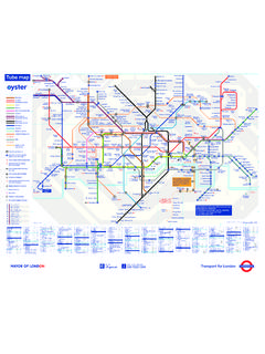
6 Totteridge & Whetstone 4D6 Tower Gateway 1D6 Tower Hill 1B5 Tufnell Park 2D2 Turnham Green 2/3A6 Turnpike Lane 3B9 Upminster 6B9 Upminster Bridge 6 Grid Station Line & ZoneC9 Upney 4B5 Upper Holloway 2C8 Upton Park 3B1 Uxbridge 6D5 Vauxhall 1/2D5 Victoria 1F5 Waddon Marsh SB7 Walthamstow Central 3B7 Walthamstow Queen s Road 3F5 Wandle Park SE5 Wandsworth Road* 2B8 Wanstead 4B8 Wanstead Park 3D7 Wapping 2C5 Warren Street 1C4 Warwick Avenue 2D5 Waterloo 1A1 Watford 7A2 Watford Junction SA2 Watford High Street 8F6 Wellesley Road SB2 Wembley Central 4B3 Wembley Park 4C2 West Acton 3C3 Westbourne Park 2D4 West Brompton 2F6 West Croydon S/5D7 Westferry 2A4 West Finchley 4C8 West Ham 3B4 West Hampstead 2B2 West Harrow 5D7 West India Quay 2D3 West Kensington 2D5 Westminster 1B1 West Ruislip 6D8 West Silvertown 3C6 Whitechapel 1D3 White City 2B3 Willesden Green 2/3C3 Willesden Junction 2/3E4 Wimbledon 3/SE4 Wimbledon Park 3A8 Woodford 4B8 Woodgrange Park 2/3A5 Wood Green 3D3 Wood Lane 2F7 Woodside SA4 Woodside Park 4D9 Woolwich Arsenal 4* Opens 2012A new angle on the London UndergroundCreating a tube map for the 21st centuryWe welcome your views and ideas about this map and your experiences of using the London Underground system.
7 You can contribute via our website which has links to the blog, twitter and facebook. Our aim is to create a dynamic map that responds to the needs of the user, makes best use of technology, and reflects the way we live our lives in the 21st more information please contact: designed by Mark Noad ( ) Typeface designed by Dave Farey ( ) Website built by Notch Design ( )The original London Underground diagram, designed by Harry Beck is one of the greatest designs of the twentieth century. He rationalised and clarified a complex system to produce a simple, easy to follow piece of information graphics. The principles he established for the diagram are still in use , in 1931 when it was first used, there were only seven lines so the compromises Beck made on geographical accuracy did not matter greatly. Today, with the constant development of the diagram now accommodating twice as many lines, these inaccuracies are more of a problem.
8 Indeed, they form the basis for a major criticism of the diagram, that it bears little or no relation to London at street is particularly the case with newer lines especially London Overground which has been shoe-horned in leaving stations nowhere near their neighbours, for example: Watford and Watford Junction; Archway and Upper Holloway; Seven Sisters and South Tottenham; South Acton and Chiswick map illustrated here is an attempt to see if it is possible to create a geographically-accurate representation of the underground system while still retaining some of the clarity of Beck s original diagram. It uses similar principles, fixed line angles in this case 30 and 60 degrees instead of 45 and shortens the extremities of the lines to make it more the position of the stations the most important element of the design means there is less space for the station names. To allow for this, a new condensed typeface has been created New Underground Condensed which is based on Edward Johnston s original font.
9 This map will help visitors to London navigate the city more efficiently. It will make it easier to decide which route to take including whether it is quicker to walk between stations. As the project develops, we will add more information to help users of the underground system which will be accessible on-line, in print, and via the app.