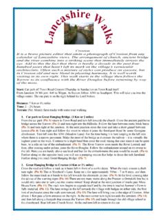
Transcription of a s h ire a
1 LancashireWalksWard StoneThe Forest of Bowland Area of Outstanding Natural Beauty offers wild and wonderful walking. Yet again here is apart of Lancashire that is under appreciated by walkers from outside the county who are more likely to be drawn tothe Lakes and Dales. Consequently when there are hoards ascending Skiddaw or Pen-y-ghent, the high fells ofBowland are quiet. For this walk, unless proficient with map and compass, readers are advise to choose a day duringa spell of fine settled weather. In mist the tops can be confusing places and after prolonged rainfall are very boggy.(Pic Dog restrictions apply on this walk)Start: Jubilee Tower car park, on the fell road between Quernmore and : 18 Km or 11 milesTime: 5 - 6 hoursTerrain: A walk in two halves!
2 Over Grit Fell and Ward's Stone rough moorland - boggy in places andstrenuous. Ondescent easy track and road walking, but with a long haul back to the car Car Park to summit of Ward's Stone (5 KM or 3 miles: 1 - 2 hours)With your back to Jubilee Tower walk to rear of car park. With the fence on your right follow a hardly discerniblefootpath that leads straight up the fellside.(Pic 1) On the skyline a cuboid cairn will provide an aiming point if thefence is not straight enough for you.(Pic 2) Amongst an area of gritstone you will reach a ladder stile over a wirefence.(Pic 3) Beyond it take a footpath through bilberry and heather that soon crosses by the summit cairn, of thiswell named Grit Fell on its march to distant Ward's Stone to the The trick now is to stay on the path as itribbons its way along the ridge.
3 At some points, especially after crossing a landrover track, detours becomenecessary to avoid patches of saturated ground. The way dips between Grit Fell and Ward's Stone, then begins toclimb along a shallow rock strewn gully to reach the first of two trig. points.(Pic 4) Here there is an impressivegritstone outcrop that presumably gave the fell its name.(Pic 5)2. Ward's Stone to Tarnbrook (9 Km or 5 miles: 2 - 3 hours)Even in clear weather picking up the path is not easy. Maintaining the same direction of travel from Grit Fell , look for the second trig. point on the horizon. A boundary stone will be passed after 150m or so. Afterreaching the second trig.
4 Point, at 561m one metre higher than the first,(Pic 6) drop down on a more definite path tothe corner of a fence.(Pic 7) This fence now provides a handrail to guide you over the next section of the route. Ontwo stretches the fence becomes a wall. Keep the fence/wall on your left as you progress along the broad ridgemoving closer to the next summit, Wolfhole Crag. In this way you will intercept a landrover track that crosses yourpath, 2 Km (45mins) from the 2nd trig. point.(Pic 8) Turn right and head down the fellside.(Pic 9) (if the weatheris severe you may wish to shelter in a shooters hut just above the waterfalls.(Pic 10) Follow the track as it winds itsway down the fellside(Pic 11) and after an hour after joining it, you will arrive at the tiny settlement of Tarnbrook.)
5 (Pic 12)3. Tarnbrook to Jubilee Tower (5 Km or 3 miles: 1-1 hours)The directions for this section are simply given. Follow the lane through the hamlet and keep on it(Pic 13) to LowerLee and the junction with the Abbeystead Road.(Pic 14) Here bear right and on a busier road (very busy atweekends) walk up the hill to the Jubilee Tower.(Pic 15) Easy eh! Well no - these last miles may seem particularlywearying. The lovely bubbly Tarnbrook Wyre will doubtless offer some distraction on the first section, and later thewide views beyond Rakehouse Brow will compensate for the effort, but the effort has still got to be made. Once onthe main road keep to the right to face the oncoming traffic.
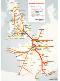
6 Eventually Jubilee Tower will come into 1 Pic 2 Pic 3 Pic 5 Pic 6 Pic 7 Pic 9 Pic 10 Pic 11 Pic 13 Pic 14 Pic 15 Jubilee TowerPic 4 Pic 8 Pic 12 Map byChris Wyattat TheBlackpool Gazette1234 56789101112131415


![[Chem²ath Contest Chemistry Questions] - Ghent](/cache/preview/7/7/3/c/6/a/b/3/thumb-773c6ab3f316a02aeb943501e4c2b967.jpg)