Transcription of Adventure Guide - National Park Service
1 Appalachian National Scenic Trail National park Service Georgia to Maine Department of the Interior Adventure Guide For Teens The Appalachian Trail Along Blue Ridge Parkway Explore, Learn, Protect ivit ct y A. Contents 1 Getting Started Activity 1 Getting Started 3 Use the Appalachian Trail brochure to answer the following questions about the Appalachian Trail commonly referred to as simply the Learn about the history and management of the Appalachian Trail from the Who was the planner to formally propose the construction of the Appalachian Trail? Appalachian Trail map/brochure Activity 2 Map it 4. Activity 3 Take a Hike 7. Who combined forces to open a continuous trail by 1937?
2 A Trail Assessment Activity 4 A Thru-Hikers Journey 9. Read a real thru-hiker's journal and answer questions How is the marked? Ready. Set. How are connecting side trails marked? Who manages the Trail's day-to-day operations and who do they work with? Which local Trail club maintains the Trail along the Blue Ridge Parkway? Created in partnership with the Appalachian Trail Conservancy with support from Unilever, National park Foundation, and the Max How many states will you pass through on a thru-hike ? and Victoria Dreyfus Foundation, Inc. Special thanks to Leigh Jenkins, Science Teacher, Berkley Springs High School, and Graduate Student, Curriculum Development, Shepherd University.
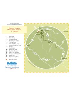
3 PAGE PAGE . ivit ct y A. 2 Map it Trail passes overlook with views to the north and east. Cross Mill Creek, and reach old road. continues straight ahead Hikers will use maps and guidebooks to plan their and ascends Elk Mountain. hike. They will need to decide where they will park , how far they can go, whether they can hike Paul C. Wolfe Shelter. a loop trail or go up and back along the same route, the difficulty of the hike, how long it will Leave No take them, and what to pack. Trace On the next two pages you will find a Guide - Principles book description of the along the Blue 1. Know Before You Go Ridge Parkway, and a map. Be Prepared. Paul C. Wolfe Shelter Answer the questions and plan your hike.
4 2. Choose the Right Path Stay on the Trail. Questions 3. Trash Your Trash Based on the information above and the weather today, what would you pack Pack it in. Pack it out. for a hike? The Appalachian Trail Conservancy produces the Appalachian Trail Guide to Central Virginia. 4. Leave What You Find The following is an adapted description for the As you found it Trail along the northern section of the Blue Ridge 5. Be Careful With Fire Parkway leading to the Paul C Wolf Shelter. Use a camp stove. (bold numbers display the mileage for each Using the map key on the next page identify the Appalachian Trail it is marked by section): 6. Respect Wildlife a dashed line (------) and an AT map scale is 1 inch = 1 mile.
5 Never approach, feed, or Detailed Trail Data South to North: follow From the Humpback Gap Parking 7. Be Kind to Other Area mile post (just south of the Visitors Humpback Rocks Visitor Center): Listen to nature and avoid loud noises. Plan a hike to the Paul C. Wolfe Shelter or another location such as Humpback Rocks. Hike 1 mile up side trail to meet the What is the estimated roundtrip mileage of your planned hike? Appalachian Trail. Turn left, heading Care for Special Places Visit Leave No Trace, Inc. north. Reach woods road with blue-blazed side for more information trail coming from the left. turns sharply right and, in 300 feet, turns sharply left onto a graded trail before How long do you think it would take you to hike your planned route?
6 Descending gradually over a series of switchbacks. PAGE PAGE . ivit ct y A. 3 Take a Hike But Wait . First, we want you to know a little bit about trail management. Many people think the Appalachian Trail is an old Indian trail or connect- ed using old animal trails. Actually the Trail was constructed through the efforts of thousands of volunteers. Today more than 5,000 volun- teers continue to maintain the Trail from Georgia to Maine. The Appalachian Trail is primarily a backcountry or primitive trail to provide a wilderness experience. We also want to protect the sur- rounding natural and cultural resources, so we design and construct the Trail with these values in mind.
7 Trail construction and maintenance involves the building of rock steps, bridges, and placing the path on the landscape so that it is not eroded by water. In some places water bars (logs or rocks placed in the Trail) divert water off of the Trail surface. Vegetation needs to be trimmed back from the Trail edges. Trail blazes and signs need to be placed appropriately so hikers can find their way. While you are hiking, take note of the condition of the Trail. Proud trail builders Field Notes Is it in good condition? Was it easy to find your way? Are there improvements you would suggest? What was your favorite section of Trail? PAGE PAGE . ivit ct y A. There are approximately 240 shelters along the Appalachian Trail from Georgia to Maine, each about a days hike apart.
8 Each shelter is unique. 4. A Thru-Hiker's Journey However, the one thing they all have in common is they provide a register for hikers (day hikers, weekend backpackers and thru-hikers). to write their thoughts, draw pictures, and leave messages for future Read the following journal entries and answer questions. hikers. If you hiked to the Paul C. Wolfe shelter or another shelter along the Blue Ridge Parkway, write an entry in the register including thoughts of your hike and the Appalachian Trail. Mark Hughes, Thru-Hiker, 2004. If you hiked to Humpback Rocks or another location on the & 2006. Appalachian Trail, write your register entry and/or pictures here: Trail Name: Postcard January 23, 2006 Pure Fun To understand all that a thru-hike is before you hike is practically impossible.
9 And yet, many of us set out on this Adventure without experience. One of the greatest aspects of the is that anyone can attempt it. Packs are hoisted on brave shoulders. Then everyone gets a simple lesson in gravity. It's no secret that more hikers fail to finish their thru-hikes than those who pose next to a weather- beaten sign at Katahdin. The reasons they start are as varied as the hikers themselves. To no fault of their own, many will face physical and emotional adversaries they couldn't possibly have foreseen. A surprising amount of insecurities that have lay dormant, will bubble up the silence of the woods is a powerful trigger. Working 9 to 5. does little to prepare us for a thru-hike; fortunately it doesn't limit our imagination to what might be over the horizon.
10 Armed with only my enthusiasm, I was one of those na ve dreamers in 2002. Carrying too much gear, maildrops spaced too far apart and a mountainous foe I was completely unfamiliar with, I came off the Trail. I wanted my journey to be one of joy not drudgery. One of escape not burden. I vowed to learn a better, more joyful way to thru-hike. In 2004, a photo was taken of me standing beneath the Approach Trail arch. Filled with jitters I put my foot on the Trail and started up Springer Mountain that terribly rainy morning. What happened next included months of smiles and laughter. No wonder thru-hiking leaves such an amazing mark on us. It is the kind of experience we all seek and need.