Transcription of Agricultural Information Management System Using …
1 Hitachi Review Vol. 58 (2009), No. 6 265 Cultivating Agricultural Information Management System Using GIS Technology Improving Agricultural Efficiency through Information TechnologyOsamu NishiguchiNoriko YamagataINTRODUCTIONJAPANESE agriculture faces a number of different issues including how to improve productivity further, deliver food safety and security, pass on technology and nurture the people involved in the industry, and increase the proportion of food produced domestically. In a world where we face the possibility of resource depletion, farmers also find themselves OVERVIEW: Improving Agricultural efficiency is an issue not just for developed countries but for the entire world including emerging economies, and it is recognized that encouraging greater efficiency will intensify the need for greater use of Information technology on the farm. The Hitachi Software Engineering Co.
2 , Ltd. s Agricultural Information Management System uses GIS technology to utilize and provide unified Management of farm Information about things like products, producers, yields, and quality. The relationship between cultivation records and parameters such as product yield and quality can be presented visually by incorporating functions such as Management of production records to support the recording of past production Information for use in checking the appropriateness of Agricultural chemical use, growth analysis Using satellite images, and fertilizer planning based on soil analysis results. This allows use of Agricultural chemicals and fertilizers to be reduced by managing fertilizer application in a way that makes production more uniform, and also helps lower costs and reduce the burden on the 1 Overview of Agricultural Information Management Software Engineering Co.
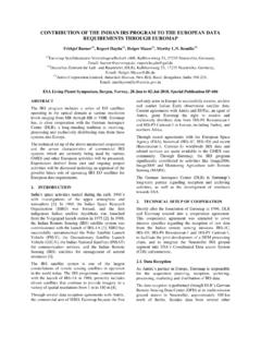
3 , Ltd. s Agricultural Information Management System applies technology from the field of GIS that it has built up over many years to overlay a wide range of different Information from the farm onto a map to provide easy-to-use ways to manage and utilize this data managementAgricultural cooperatives and othersInternetProvision of informationFarm Management supportSatellite imageField dataSoil analysis dataWheat growth in each fieldEnter Information including field area, producers, yield, and cropping records and use this as a basis to help prepare farm Management plans and manage crop rotation regimes. Enter soil analysis data and prepare optimized cropping plans based on links to past soil analysis data and keepingEnter data on Agricultural chemical and fertilizer use, and similar. Display guidelines on Agricultural chemical use and check use against these guidelines to support safety and security in food satellite images to analyze the growth of crops such as wheat and rice.
4 Use the Information to estimate quality and ideal harvesting growth analysis System Using satellite imagesNetworkEasy-to-use Internet-based System for entering production recordsFarm work diary systemProvides access to a database of cropping records, production records, soil analysis data, and data about product quality. Can also be used to update Management data and field maps prepared by the producers field Management systemSimulationSupport good soil Management by determining the optimum type and quantity of fertilizer to use based on the soil, crop, and growth application planning systemProduction records Management systemField and soil data Management systemAgricultural Information Management System Using GIS Technology 266 in a situation where they must conduct their business in a way that takes account of numerous modern-day issues other than just producing Agricultural products, including implementing sustainable Agricultural practices and reducing the burden on the environment that results from agriculture(1).
5 As this has created a need to adopt new concepts and technologies rather than just relying on traditional inputs like Agricultural machinery, Agricultural chemicals, and fertilizers, expectations for the use of Information in farming are growing(2).This article describes the Hitachi Software Engineering Co., Ltd. s Agricultural Information Management System based on GIS (geographic Information System ) technology, while also giving some examples of its use and discussing the outlook for Agricultural IT ( Information technology).MAKING USE OF Agricultural Information THROUGH Management SYSTEMOne of the important issues facing agriculture in Japan is cost reduction. But keeping use of resources such as Agricultural chemicals and fertilizers to a minimum, operating Agricultural machinery efficiently, and shortening the time taken to carry out Agricultural work will not only improve cost-competitiveness, it will also help reduce the burden on the environment.
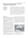
6 While delivering food safety and security requires that producers apply Agricultural chemicals and fertilizers in accordance with their guidelines for use, it is also important that actual usage be recorded correctly and in a way that permits auditing by a third party at any combined with yield, quality, and other data, production records collected for the purpose of providing food safety and security can also be put to use as valuable farming knowledge. Also, Using the same Information for multiple purposes reduces the effective cost of that started supplying the Agricultural Information Management System in 2004. The System manages Agricultural data through links with a map, and to date has been adopted at approximately 40 Agricultural cooperatives and other organizations (see Fig. 1).The System aims to help provide farm operating guidance (guidance on improving Agricultural Management and technology) by managing Information by linking it to individual farms and parcels of land Using GIS technology.
7 By managing data such as types of farm products, producers, yield, quality, soil type and analysis results, weather data, and Agricultural chemical and fertilizer usage by linking the data to locations on the farm, the System can be utilized for purposes such as supporting the preparation of cropping plans based on past cultivation records or identifying differences in the productivity of different locations which would be difficult to achieve Using ledger-based Management (see Fig. 2).HitachiSoft s Agricultural Information Management System incorporates numerous functions for utilizing data. These include a System for collecting and managing records of actual Agricultural chemical and fertilizer usage and checking whether these comply with the guidelines, a growth analysis System that uses satellite images to estimate crop yields and crop growth over a wide area, and a fertilizer planning System that advises on optimum fertilizer application based on soil analysis results.
8 Utilizing these functions can provide direction on what to do next to improve cultivation, determine quality and yield, and carry out farm work (see Fig. 3).The System can be used in many different ways. These include supporting crop rotation regimes, supporting crop planning based on knowledge of the area under cultivation, and use by producers discussing decisions about the harvesting sequence based on the use of satellite images to estimate at the state of growth of superior ease-of-use of the System allows most users to maintain for themselves data such as product Information and the farm layout that changes from year to year. This keeps field data up to date and leads to continued use of the 2 Example Screen from Field Data Management Management of field data is achieved by linking the data to a map so that it can be utilized in many different Review Vol.
9 58 (2009), No. 6 267 technology to link it to locations on the farm, the Information is made easier to manage and it also becomes possible to bring together and represent visually the many different factors that influence productivity. One example of what this makes possible is to achieve more uniform productivity across the land being farmed by adjusting fertilizer quantities on the basis that fertilizer application will influence differences in are numerous other uses for GIS technology in agriculture. Examples include taking note of past production when establishing new cropping plans in order to maintain a crop rotation regime, collating data on the total planting area for each crop, on-site reviewing of rice production adjustments, displaying the age of farmers and whether or not they have someone to take over from them on a map to determine the situation in each village, and estimation of land area on sloping land.
10 As remote sensing technologies that use satellite images can be used to estimate differences in parameters such as crop growth and yield, this Information can be used for various different purposes such as Using it as a basis for soil Management practices in the following year. By Using GPS (global positioning System ) to obtain the position of Agricultural machinery in realtime, the Information can also be used to support equipment allocation planning including identifying where to move Agricultural machinery to TECHNOLOGIES UNDERPINNED BY Agricultural Information Management SYSTEMGIS TechnologyThe Geographical Survey Institute of the Ministry of Land, Infrastructure, Transport and Tourism defines GIS technology as a technology that supports the integrated Management and processing, visual display, sophisticated analysis, and rapid evaluation of data containing location-dependent Information (spatial data) based on geographic position (4).