Example: tourism industry
August/September 2017 Hurricane Harvey - weather.gov
Cover Photograph: From August 27–September 4, the National Geodetic Survey (NGS) collected damage assessment imagery in the aftermath of Hurricane Harvey. This image is of the Route I-10 flooding near Lynchburg, TX, just about 20 miles east of downtown Houston, TX.
Tags:
Information
Domain:
Source:
Link to this page:
Documents from same domain
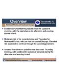
Overview Jacksonville, FL
www.weather.govBriefing Time: 7/30/2018 12:07 PM Caution: Do Not Use Beyond Eight (8) Hours from Briefing Time. Jacksonville, FL Weather Forecast Office US National Weather Service Jacksonville @NWSJacksonville Weather.gov/JAX
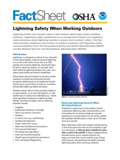
Lightning Safety When Working Outdoors
www.weather.govFactSheet. Lightning Safety When Working Outdoors. Lightning strikes can severely injure or kill workers whose jobs involve working . outdoors. Lightning is often overlooked as an occupational hazard, but employers
Heavy showers and thunderstorms could lead to …
www.weather.govWarning L Greensboro Watch Ash A' oro —"Carol'nà+san ham etteville Lumbèrtcm Mount Gree Kinston Advisory S
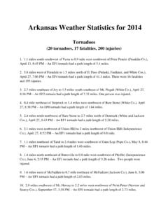
Arkansas Weather Statistics for 2014
www.weather.govArkansas Weather Statistics for 2014 ... 0.9 mile west of Bredlow Corner to 1.2 miles east-northeast of ... may be a week or more before tornadoes can be added ...
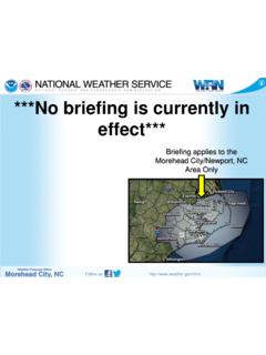
No Current Weather Hazard Briefing is in Effect. …
www.weather.govNo Current Weather Hazard Briefing is in Effect. Refresh this page frequently! Author: christopher.collins Created Date: 4/15/2014 11:46:45 AM
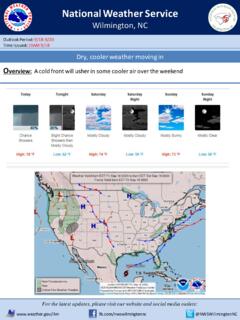
Forecaster #: 910-762-8724 Heavy rain expected …
www.weather.govWilmington . Title: PowerPoint Presentation Author: Terry Lebo Created Date: 7/24/2018 10:50:20 AM
FARGO, NORTH DAKOTA F5 TORNADO JUNE 20, 1957 HOW …
www.weather.govFARGO, NORTH DAKOTA F5 TORNADO JUNE 20, 1957 HOW THE PUBLIC WAS WARNED: A PERSONAL ACCOUNT Ray E. Jensen PhD Last Chance Ranch P. O. Box 202, Aquilla, TX 76622
Groundhog Day Weather History for Peoria
www.weather.govGroundhog Day is celebrated on February 2. According to folklore, if is cloudy when a groundhog emerges from its burrow on this day, then spring will come early. If it is sunny, the groundhog will see its shadow and retreat back into its burrow, and winter weather will continue
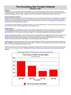
The Groundhog Day Tornado Outbreak - weather.gov
www.weather.govThe Groundhog Day Tornado Outbreak February 2, 2007 Synopsis: A deadly tornado event occurred across the NWS Melbourne County Warning Area within Lake and Volusia Counties during the
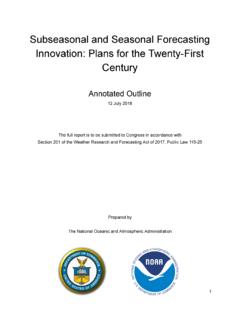
S u b se a so n a l a n d S e a so n a l F o r e ca st i n ...
www.weather.govD r a f t E xe cu t i ve S u m m a r y W i t h i n t h e p a st 2 0 ye a r s, t h e d e m a n d f o r su b se a so n a l - t o - se a so n a l ( S 2 S ) f o r e ca st i n f o r m a t i o n
Related documents
DoDEA School Year 2017-18 School Calendar August 2017 ...
feaonline.orgDoDEA School Year 2017-18 School Calendar ... December 2017 January 2018 February 2018 March 2018 April 2018 May 2018 June 2018 August 2017 September 2017 October 2017. Created Date: 1/11/2017 8:16:57 PM ...

July 2017 August 2017 September 2017 2017-2018 …
ohs.okee.k12.fl.usJuly 2017 S M T W T F S 1 2 3 4 5 6 7 8 9 10 11 12 13 14 15 16 17 18 19 20 21 22 23 24 25 26 27 28 29 30 31 September 2017

July 2017, August 2017, September - West Bengal
www.wbcomtax.nic.inJuly 2017, August 2017, September 2017 October 2017 November 2017 31.01.2018 Commissioner's Notification No. 24-C.T./GST dt. 21.12.2017 All eligible dealers declaration in respect of goods dispatched to a job worker or received from a job worker or sent from one job worker to another July 2017,

HUMBLE CITY COUNCIL MEETING PACKET SEPTEMBER 14, 2017
www.cityofhumble.comSep 14, 2017 · 6. Ordinance 17-810 extending the Disaster Declaration issued by Mayoral proclamation on August 27, 2017 and continued by Ordinance 17-808 on September 3, 2017 in response to
Management Accounting (F2/FMA) September 2017 to …
www.accaglobal.com© ACCA 2017-2018 All rights reserved. 1 Management Accounting (F2/FMA) September 2017 to August 2018 This syllabus and study guide are designed to help

Indianapolis Airport Authority September 15, 2017 8:00 AM ...
d1j6zi7czwjuok.cloudfront.netPage 1 of 1 Agenda Indianapolis Airport Authority September 15, 2017 8:00 AM I. Call to Order II. Approval of Minutes of the IAA Board’s Regular Meeting of August 18, 2017 III. Ordinances, Resolutions and Public Hearings

August 2017 September 2017 October 2017 - hayfield.k12.mn.us
hayfield.k12.mn.usAugust 2017 29 District Wide Staff Professional Development 30 District Wide Staff Professional Development HHS Open House (6 to 8 PM) September 2017

August 2017 September 2017 - New Mexico Institute of ...
infohost.nmt.eduSeptember 2017 Soil Mechanics Fall 2017 Holidays in United States August 2017 S M T W T F S 1 2 3 4 5 6 7 8 9 10 11 12 13 14 15 16 17 18 19 20 21 22 23 24 25 26

August – September 2017
www.lincoln.eduSunday, September 24, 2017 Sunday Evening Worship at 6:30 pm Sunday, October 1, 2017 Chapel Ministry Kick -Off – 10:45 a.m. Wednesday, Oct. 4, 2017 Church in the Middle – 7 p.m.
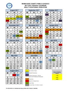
MIAMI-DADE COUNTY PUBLIC SCHOOLS 2017-2018 SCHOOL …
www.miamilakes.edu*Teachers may opt to work one or more days, August 15, 16 , 2017, in lieu of any of the teacher planning days except August 18, 2017, and the designated District-wide Professional Development Days, October 2, 2017, and October 27, 2017.
Related search queries
School Year 2017-18 School Calendar August 2017, School Year 2017-18 School Calendar, 2017, August 2017 September 2017, 2017 August 2017 September 2017 2017, September 2017, July 2017, August 2017, September, July 2017, August 2017, September 2017, September, August, Management Accounting (F2/FMA) September 2017 to, Management Accounting (F2/FMA) September 2017 to August 2018, Indianapolis Airport Authority September 15, August 2017 September 2017 October 2017, August 2017