Transcription of Bear Butte State Park PO Box 688 Sturgis, SD 57785 Bureau ...
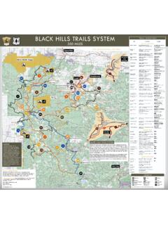
1 In the Black Hills of South DakotaIn the Black Hills of South DakotaIn the Black Hills of South DakotaIn the Black Hills of South DakotaAgency Addresses and Phone NumbersVehicle SecurityLong-term parking is available at many of the trailheads as shown on the reverse of this brochure. If you plan to leave your vehicle overnight or longer in Fort Meade Recreation Area, Bear Butte State Park, or Wind Cave National Park, please notify a ranger. Doing this will let park managers know why a vehicle has been left at a fires are not permitted. An open fire is defined as any fire burning slash, brush, grass, stubble, debris, rubbish, or other inflammable material not enclosed in a stove, spark-proof incinerator, or an established fireplace approved or constructed by public agencies in designated recreation areas.
2 Campfire grates are provided in many campgrounds for campground users. Please be careful with EthicsThe centennial trail has been developed for you to enjoy. Please help us keep the trail clear of trash by packing out all of your litter and food residue. When camping, use minimum impact techniques and practice Leave No Trace ethics. If using a motorized vehicle on the trail where permitted, TREAD LIGHTLY and protect the environment you enjoy. When meeting other parties on the trail , allow room to pass. Horse riders will require extra space. Bikes yield to hikers; hikers yield to need your comments on your centennial trail experience. Did you find the trail signing adequate? Were the facilities along the trail adequate? Were you able to find enough information to plan your trip?
3 Please send any comments you may have to the supervisor of any agency listed on this MapsThis trail is shown in detail on two different Trails Illustrated maps which are available for approximately $ *. The Black Hills National Forest visitor map can be purchased from any of the agencies listed for approximately $ *. This map provides information about road access to the trailheads. *Prices are subject to of Land Management310 Roundup Fourche, SD 57717(605) Butte State ParkPO Box 688 Sturgis, SD 57785 (605) Canyon Ranger District330 Mt. Rushmore RoadCuster, SD 57730(605) 673-4853 Mystic Ranger District8221 S. Hwy 16 Rapid City, SD 57702(605) 343-1567 Northern Hills Ranger District2014 N. Main , SD 57783(605) Hills National Forest1019 N. 5th , SD 57730(605) 673-9200 TDD (605) 673-9227 Custer State Park13329 Highway 16 ACuster, SD 57730(605) 255-4515 Wind Cave National Park26611 Highway 385 Hot Springs, SD 57747(605) agencies are equal opportunity employers and the Black Hills of South DakotaIntroductionMarking the 100th anniversary of statehood, 1889 to 1989, the 111-mile centennial trail represents the diversity of South Dakota.
4 The trail crosses the prairie grasslands near Bear Butte State Park and climbs into the Black Hills high country, skirting lakes and streams until it reaches Wind Cave National Park near Hot Springs. The Forest Service, Bureau of Land Management, National Park Service, and South Dakota Department of Game, Fish and Parks have combined their efforts to develop this trail for you to trail UsesBy Management AgencyHikingHorseridingMountain BikingMotorized VehiclesYesYesNoYesYesYesNoYesYesYesNoYe sYesNoNoYesYesYesNoYesNoNoFt. Meade Recreation AreaBureau of Land Hills National ForestBlack Elk WildernessCuster State ParkBear Butte State ParkWind Cave National Park*Trip PlanningPlanning will help you enjoy your trip on the centennial trail . Find out as much as you can about the area where you plan to use the trail .
5 Drinking water is not readily available along the trail . Many of the streams dry up in early summer. Protect yourself and treat raw water taken from streams and lakes before you drink it. Many of the established campgrounds and picnic areas along the trail have drinking water during the summer months of June, July, and August. During the rest of the year, campground water systems are turned off. Be prepared for unexpected changes in the weather, and for emergencies. Food is not readily available along the trail . Food may be obtained from stores in the Black Hills , Fees, and CampingMany of the campgrounds along the trail charge a fee. Some campgrounds also require a reservation ahead of time. The facility list on the reverse of this brochure indicates which facilities require a use fee and Elk Wilderness portion of the trail requires free registration for anyone using the Wilderness.
6 This registration form describes the rules and regulations of the Black Elk Wilderness and are available at Wilderness Trailheads. Bicycles are not allowed in the State Park requires the purchase of a park entrance license for vehicles to use the Park. Annual and temporary permits are available. No permit is required to hike or bike through Custer State Park. Within Custer State Park, camping is only allowed in developed campgrounds, except in the French Creek Natural Area where camping is allowed anywhere along the trail . Wind Cave National Park requires a free backcountry permit for those who plan to camp in the backcountry. This permit describes requirements which must be followed when camping in the backcountry of Wind Cave National Park. Permits are available at Wind Cave National Park trailheads.
7 Bicycles are not allowed off designated COURTESYE xpect and respectother trail users**Horse and mountain bike use is not allowed in the eastern portion of Bear Butte State Park. Along the trail several short stretches are designated for hiker use only. Bypass routes are signed for other trail user types.*Motorized use of the centennial trail is allowed only on some portions of the trail between Pilot Knob Trailhead and Dalton Trailhead. Use alternate routes as **NoSCALE12340(miles)#^^^^^^^^^^^^^^^^^^ ^^^^^^^^^^^^^^^^^^^^^^^^^^^^^^^^^^^^^^^^ ^^^^^^^^^^^^^^^^^^^^^^^^^^^^^^^^^^^^^^^^ ^^^^^^^^^^^^^^^^^^^^^^^^^^^^^^^^^^^^^^^^ ^^^^^^^^^^^^^^^^^^^^^^^^^^^^^^^^^^^^^^^^ ^^^^ centennial TRAILCENTENNIAL TRAILBear Butte - centennial trail begins in the north at the top of Bear Butte . At 4,422 feet, Bear Butte is a sacred place for the American Indian.
8 The Butte is a laccolith formed by a molten magma intrusion that has been exposed by erosion of the surrounding prairie - The Black Hills area provides habitat for many wildlife species. You might see antelope, bighorn sheep, mule deer, white-tailed deer, elk, turkeys, or mountain goats. There are about 370 miles of trout fishery streams in the Black Hills. The centennial trail crosses a number of these and Reservoirs - The centennial trail passes by or near seven bodies of water, each with its own special character. Sheridan Lake and Pactola Reservoir are popular recreation spots for boating, fishing and swimming. Trout fishing is especially popular. Most lakes are stocked with fish by the South Dakota Department of Game, Fish and - Black Hills geology is very complex.
9 The Hills were formed by the uplifting of the earth s crust millions of years ago. Precambrian rock formations, consisting of slate, schist and granite, form a central core. Harney Peak at 7,242 feet and the nearby Needles are part of this core. Surrounding the central core are rings of sedimentary rocks consisting of sandstone, limestone, and shale in which occur many well-known caves, such as Wind Cave and Jewel Rushmore - The centennial trail passes within one mile of Mt. Rushmore National Memorial. Mt. Rushmore serves as the Shrine of Democracy with sixty-foot likenesses of Presidents Washington, Jefferson, Teddy Roosevelt, and Lincoln carved into the Bison (Buffalo) - Buffalo herds roam Custer State Park and Wind Cave National Park. They are exciting to watch, but can be dangerous and unpredictable if approached.
10 View from a safe - The Black Hills are rich in both American Indian and early American history. Archeological evidence suggests American Indian use of the area began about 10,000 years ago. The first expedition to explore the Black Hills was Custer s Expedition in 1874, two years before his death at the Little Big Horn in Montana. The centennial trail passes many historical TRAILCENTENNIAL TRAILMt. RushmoreBuffalo shedding its winter coatBlack Hills rock formationsLegion LakeView of Bear ButteCuster and his officersTRAILHIGHLIGHTSTRAILHIGHLIGHTSTR AILHIGHLIGHTSTRAILHIGHLIGHTSB ighorn sheepXXXXXXXXXXXXXXXXXXXXXXXXXXXXXXXXXXX XXXXXXXXXXXXXXXXXXXXXXXXXXXXXXXXXXXXXXXX XXXXXXXXXXXXXXXXXXXXXXXXXXXXXXXXXXXXXXXX XXXXXXXXXXXXXXXXXXXXXXXXXXXXXXXXXXXXXXXX XXXXXXXXXXXXXXXXXXXXXXXXXXXXXXXXXXXXXXXX XXXXXXXXXXXXXXXXXXXXXXXXXXXXXXXXXXXXXXXX XXXXXXXXXXXXXXXXXXXXXXXXXXXXXXXXXXXXXXXX XXXXXXXXXXXXXXXXXXXXXXXXXXXXXXXXXXXXXXXX XXXXXXXXXElk Mountain CGWind CaveVisitor CenterNorbeck THHighland Creek THFrench CreekHorse Camp 3 French CreekNatural AreaBadger Hole THIron Creek THIron Creek Horse CGMount RushmoreNational MemorialWillow Creek THBig Pine THSpring Creek THDakota Point THSheridan