Transcription of Case Study I* - The Ganga, India
1 Water Pollution Control - A Guide to the Use of Water Quality Management Principles Edited by Richard Helmer and Ivanildo Hespanhol Published on behalf of the United Nations Environment Programme, the Water Supply & Sanitation Collaborative Council and the World Health Organization by E. & F. Spon 1997 WHO/UNEP ISBN 0 419 22910 8 Case Study I* - The ganga , India * This case Study was prepared by Y. Sharma Introduction There is a universal reverence to water in almost all of the major religions of the world. Most religious beliefs involve some ceremonial use of "holy" water. The purity of such water, the belief in its known historical and unknown mythological origins, and the inaccessibility of remote sources, elevate its importance even further. In India , the water of the river ganga is treated with such reverence. The river ganga occupies a unique position in the cultural ethos of India .
2 Legend says that the river has descended from Heaven on earth as a result of the long and arduous prayers of King Bhagirathi for the salvation of his deceased ancestors. From times immemorial, the ganga has been India 's river of faith, devotion and worship. Millions of Hindus accept its water as sacred. Even today, people carry treasured ganga water all over India and abroad because it is "holy" water and known for its "curative" properties. However, the river is not just a legend, it is also a life-support system for the people of India . It is important because: The densely populated ganga basin is inhabited by 37 per cent of India 's population. The entire ganga basin system effectively drains eight states of India . About 47 per cent of the total irrigated area in India is located in the ganga basin alone. It has been a major source of navigation and communication since ancient times.
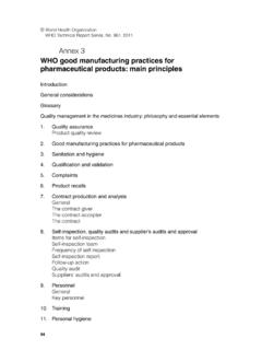
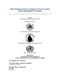
3 The Indo-Gangetic plain has witnessed the blossoming of India 's great creative talent. The ganga river The ganga rises on the southern slopes of the Himalayan ranges (Figure ) from the Gangotri glacier at 4,000 m above mean sea level. It flows swiftly for 250 km in the mountains, descending steeply to an elevation of 288 m above mean sea level. In the Himalayan region the Bhagirathi is joined by the tributaries Alaknanda and Mandakini to form the ganga . After entering the plains at Hardiwar, it winds its way to the Bay of Bengal, covering 2,500 km through the provinces of Uttar Pradesh, Bihar and West Bengal (Figure ). In the plains it is joined by Ramganga, Yamuna, Sai, Gomti, Ghaghara, Sone, Gandak, Kosi and Damodar along with many other smaller rivers. Figure Location map of India showing the ganga river The purity of the water depends on the velocity and the dilution capacity of the river .
4 A large part of the flow of the ganga is abstracted for irrigation just as it enters the plains at Hardiwar. From there it flows as a trickle for a few hundred kilometres until Allahabad, from where it is recharged by its tributaries. The ganga receives over 60 per cent of its discharge from its tributaries. The contribution of most of the tributaries to the pollution load is small, except from the Gomti, Damador and Yamuna rivers, for which separate action programmes have already started under Phase II of "The National Rivers Conservation Plan". The ganga river carries the highest silt load of any river in the world and the deposition of this material in the delta region results in the largest river delta in the world (400 km from north to south and 320 km from east to west). The rich mangrove forests of the Gangetic delta contain very rare and valuable species of plants and animals and are unparalleled among many forest ecosystems.
5 Figure Map of India showing the route of the ganga river Exploitation In the recent past, due to rapid progress in communications and commerce, there has been a swift increase in the urban areas along the river ganga , As a result the river is no longer only a source of water but is also a channel, receiving and transporting urban wastes away from the towns. Today, one third of the country's urban population lives in the towns of the ganga basin . Out of the 2,300 towns in the country, 692 are located in this basin , and of these, 100 are located along the river bank itself. The belief the ganga river is "holy" has not, however, prevented over-use, abuse and pollution of the river . All the towns along its length contribute to the pollution load. It has been assessed that more than 80 per cent of the total pollution load (in terms of organic pollution expressed as biochemical oxygen demand (BOD)) arises from domestic sources, from the settlements along the river course.
6 Due to over-abstraction of water for irrigation in the upper regions of the river , the dry weather flow has been reduced to a trickle. Rampant deforestation in the last few decades, resulting in topsoil erosion in the catchment area, has increased silt deposits which, in turn, raise the river bed and lead to devastating floods in the rainy season and stagnant flow in the dry season. Along the main river course there are 25 towns with a population of more than 100,000 and about another 23 towns with populations above 50,000. In addition there are 50 smaller towns with populations above 20,000. There are also about 100 identified major industries located directly on the river , of which 68 are considered as grossly polluting. Fifty-five of these industrial units have complied with the regulations and installed effluent treatment plants (ETPs) and legal proceedings are in progress for the remaining units.
7 The natural assimilative capacity of the river is severely stressed. The principal sources of pollution of the ganga river can be characterised as follows: Domestic and industrial wastes. It has been estimated that about 106 m3 d-1 of domestic wastewater and 106 m3 d-1 of industrial sewage are going into the river . Solid garbage thrown directly into the river . Non-point sources of pollution from agricultural run-off containing residues of harmful pesticides and fertilisers. Animal carcasses and half-burned and unburned human corpses thrown into the river . Defecation on the banks by the low-income people. Mass bathing and ritualistic practices. The ganga Action Plan Scientific awareness There are 14 major river basins in India with natural waters that are being used for human and developmental activities. These activities contribute significantly to the pollution loads of these river basins.
8 Of these river basins the ganga sustains the largest population. The Central Pollution Control Board (CPCB), which is India 's national body for monitoring environmental pollution, undertook a comprehensive scientific survey in 1981-82 in order to classify river waters according to their designated best uses. This report was the first systematic document that formed the basis of the ganga Action Plan (GAP). It detailed land-use patterns, domestic and industrial pollution loads, fertiliser and pesticide use, hydrological aspects and river classifications. This inventory of pollution was used by the Department of Environment in 1984 when formulating a policy document. Realising the need for urgent intervention the Central ganga Authority (CGA) was set up in 1985 under the chairmanship of the Prime Minister. The ganga Project Directorate (GPD) was established in June 1985 as a national body operating within the National Ministry of Environment and Forest.
9 The GPD was intended to serve as the secretariat to the CGA and also as the Apex Nodal Agency for implementation. It was set up to co-ordinate the different ministries involved and to administer funds for this 100 per cent centrally-sponsored plan. The programme was perceived as a once-off investment providing demonstrable effects on river water quality. The execution of the works and the subsequent operation and management (O&M) were the responsibility of the state governments, under the supervision of the GPD. The GPD was to remain in place until the GAP was completed. The plan was formally launched on 14 June 1986. The main thrust was to intercept and divert the wastes from urban settlements away from the river . Treatment and economical use of waste, as a means of assisting resource recovery, were made an integral part of the plan. It was realised that comprehensive co-ordinated research would have to be conducted on the following aspects of ganga : The sources and nature of the pollution.
10 A more rational plan for the use of the resources of the ganga for agriculture, animal husbandry, fisheries, forests, etc. The demographic, cultural and human settlements on the banks of the river . The possible revival of the inland water transport facilities of the ganga , together with the tributaries and distributaries. One outcome of this initiative was a multi-disciplinary Study of the river in which the 14 universities located in the basin participated in a well co-ordinated, integrated research programme. This was one of largest endeavours, involving several hundred scientists, ever undertaken in the country and was funded under the GAP. The resultant report is a unique, integrated profile of the river . The GAP was only the first step in river water quality management. Its mandate was limited to quick and effective, but sustainable, interventions to contain the damage.