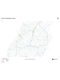
Transcription of ce hy le ly - U.S. DEPARTMENT OF THE INTERIOR
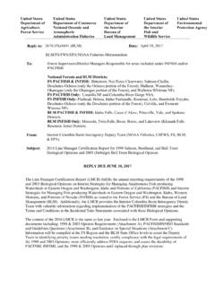
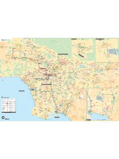
1 JR y oivhenr Da CoRluivmebria Deschutes River hnRDiavyer JoRiver John Day RDJivoaehyrn Nort Fork Johhn Day River PacificOcean 0 14 19 84 206 Falls 97 BoatabWARNING: 10 Not Blalock Tumwater Falls ( class 5 Rapids) le John Day(McDonaldCrossing 20 Wasco Rock Creek(Walk-i ) ) Segmen1B Rivert 74 206 nStarvatiLane on 207 97 30 CottonwoodMoro Bridge MikkaRiverSegment Ione 1A 40 lo Lower 50 Day John WSA 19 207 Grass Valley RiverHeppner Segment206 60 2B 206 206 216 70 ThirtymileWSA 97 Thirtymile 80 Condon Hardman 19 90 North Pole Ridge WSA River207 100 Segment Fossil Shaniko 2A 97 218 John RiverFoss i Day 19 l Beds (Clarno Unit) RiverRiverRiverSegment Antelope Clarno Segment Segment Segment 218 110 218 Nor6t3B 3A 4 Forkh 97 Clarno East 293 (Private-Closed)
2 SpriBasingn Wilderness Wooden19 170 Spray 120 Muleshoe Bridge Big402 Spray LowerBend 130 Service Creek 160 BurntiRanch PrHoest lBurne Twi140 150 Creekce Kickenham Servi180 19 mbert Beach Ranch (WaPatSutt207 CabsMounonWSAn WSA n y Kimberl0 lk-in) itai ly 190 19 Legend Boating Access Points Boating Access Points Walk-in Access Points River Mile Markers Towns Tumwater Falls River Segments HighwaysRoads Wilderness Study Areas Wilderness Area Bureau of Land Management Forest Service National Park Service Other Federal State Private John Day River (Mainstem) Boating Access Points 0 510 Miles DEPARTMENT OF THE INTERIOR Bureau of Land Management PRINEVILLE district 3050 NE Third Street, Prineville, OR 97754 Phone: 541-416-6700 No warranty is made by the Bureau of Land Management as to the accuracy, reliability, or completeness of these data for individual or aggregate use with other data.
3 Original data were compiled from various sources and may be updated without notification. MXD: P:\pri\gis_projects\recreation\Wild_and_ Scenic_Rivers\John_Day_WSR\John_Day_ River_Boating_Maps\MXD\ Last Modified Date: 5/14/2018 Astoria WASHINGTON Portland The Dalles Pendleton MapSalem Fossil Location Baker City Prineville Prineville John Day Florence district Eugene Bend Burns Jordan Valley OREGON Medford KBrookings lamath Falls Lakeview CALIFORNIA NEVADA IDAHO