Transcription of Chapter 5.0: Zoning and Land Use - Ontario, California
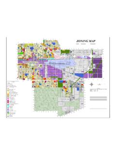
1 Chapter : Zoning and Land Use Division Zoning Districts and Boundaries Division Land Use Division Standards for Certain Land Uses, Activities, and Facilities This page intentionally left blank Ontario Development Code Page (Rev. 20160503) Division Zoning Districts and Boundaries Sections: : Purpose : Establishment of Base Zoning Districts : Zoning Map Adoption : Zoning District Boundaries : Purpose The purpose of this Division is to establish Zoning districts to implement the goals of the community as stated in The Ontario Plan. The text and maps of the Policy Plan component of The Ontario Plan will provide additional guidance in the development and use of properties throughout the City. : Establishment of Base Zoning Districts In order to carry out the purpose and provisions of this Development Code, the City is hereby divided into the following Zoning districts: A.
2 Residential Zoning Districts. 1. AR-2 (Residential-Agricultural- 0 to DU/Acre) Zoning District. The AR-2 Zoning district is hereby established to accommodate single-family residences on large lots, at a density range of 0 to dwelling units per acre, and allow for limited agricultural activities and animal keeping within a rural environment. The AR-2 Zoning district is further intended to maintain a rural agricultural heritage and protect the area from suburban infringement, while maintaining a harmonious relationship between the rural and adjacent suburban land uses. The AR-2 Zoning district is consistent with and implements the Rural Residential land use designation of the Policy Plan component of The Ontario Plan. 2. RE-2 Rural Estate 0 to DU/Acre) Zoning District. The RE-2 Zoning district is hereby established to accommodate single-family residences on larger lots, at a density range of 0 to dwelling units per acre, in a semi-rural environment where limited animal keeping is permitted.
3 The RE-2 Zoning district is consistent with and implements the Rural Residential land use designation of the Policy Plan component of The Ontario Plan. 3. RE-4 Residential Estate to DU/Acre) Zoning District. The RE-4 Zoning district is hereby established to accommodate single-family homes on estate-sized lots, in a suburban environment, at a density range of to dwelling units per acre. The RE-4 Zoning district is consistent with and implements the Low Density Residential land use designation of the Policy Plan component of The Ontario Plan. 4. LDR-5 (Low Density Residential to DU/Acre) Zoning District. The LDR-5 Zoning district is hereby established to accommodate single-family homes on individual lots, in a suburban environment, at a density range of to dwelling units per acre.
4 The LDR-5 Zoning district is consistent with and implements the Low Density Residential land use designation of the Policy Plan component of The Ontario Plan. Division Zoning Districts and Boundaries (Rev. 20160503) Page Ontario Development Code 5. MDR-11 (Low-Medium Density Residential to DU/Acre) Zoning District. The MDR-11 Zoning district is hereby established to accommodate a variety of attached and detached housing types, in a suburban environment, at a density range of to dwelling units per acre. The MDR-11 Zoning district is consistent with and implements the Low-Medium Density Residential land use designation of the Policy Plan component of The Ontario Plan. 6. MDR-18 (Medium Density Residential to DU/Acre) Zoning District. The MDR-18 Zoning district is hereby established to accommodate a variety of attached and detached housing types, in a suburban environment, at a density range of to dwelling units per acre.
5 The MDR-18 Zoning district is consistent with and implements the Medium Density Residential land use designation of the Policy Plan component of The Ontario Plan. 7. MDR-25 (Medium-High Density Residential to DU/Acre) Zoning District. The MDR-25 Zoning district is hereby established to accommodate higher density residential developments, in a more urbanized environment, at a density range of to dwelling units per acre. The MDR-25 Zoning district is consistent with and implements the Medium Density Residential land use designation of the Policy Plan component of The Ontario Plan. 8. HDR-45 (High Density Residential to DU/Acre) Zoning District. The HDR-45 Zoning district is hereby established to accommodate high-density multiple-family developments in an urban environment, generally located within 1/2-mile of a transit corridor or station, at a density range of to dwelling units per acre.
6 The HDR-45 Zoning district is consistent with and implements the High Density Residential land use designation of the Policy Plan component of The Ontario Plan. B. Commercial Zoning Districts. 1. CS (Corner Store) Zoning District. The CS Zoning district is hereby established to accommodate pedestrian-oriented neighborhood retail and service establishments developed at a maximum intensity of FAR, which would have few impacts to adjacent residential uses due to the types of uses allowed and their limited hours of operation. CS Zoning district locations are within established or planned neighborhoods, generally along residential collector streets, and are intended to provide their goods and services within walking distance to most of their customers. This Zoning district provides for a scale and character of development that tends to attract and promote a walk-in clientele.
7 Development within the CS Zoning district should maximize human scale design elements, while providing a sensitive transition between the allowed uses and neighboring residences, including the provision of adequate and properly sited parking (including allowances for on-street parking). Sites within this Zoning district are typically small in size (less than ), are usually stand-alone land uses, and are intended to fit into and protect the residential pattern of development. The CS Zoning district is consistent with and implements the Neighborhood Commercial land use designation of the Policy Plan component of The Ontario Plan. 2. CN (Neighborhood Commercial Maximum FAR) Zoning District. The CN Zoning district is hereby established to accommodate the development of convenience centers at a maximum intensity of FAR, and are intended to serve residents within a one to 2-mile radius, with some customers within walking distance.
8 Intended uses are smaller-scale, which support the local market rather than a citywide or regional market ( , the difference between a Best Buy and a Radio Shack). Given their proximity to residential uses, the hours and types of uses allowed within the CN Zoning district may be limited either by ordinance or by conditions of approval. Uses may be standalone or within a center generally 10 to 15 acres in size. The CN Zoning district is Division Zoning Districts and Boundaries Ontario Development Code Page (Rev. 20160503) consistent with and implements the Neighborhood Commercial land use designation of the Policy Plan component of The Ontario Plan. 3. CC (Community Commercial Maximum FAR) Zoning District. The CC Zoning district is hereby established to accommodate retail, office, and service uses developed at a maximum intensity of FAR, which serve residents within a 5-mile radius.
9 If located within close proximity to residential areas, the operation of the commercial land uses may be limited to protect the nearby sensitive uses. Commercial uses within the CC Zoning district may be standalone or within centers generally 10 to 20 acres in size. The CC Zoning district is consistent with and implements the General Commercial land use designation of the Policy Plan component of The Ontario Plan. 4. CR (Regional Commercial Maximum FAR) Zoning District. The CR Zoning district is hereby established to accommodate commercial and entertainment centers which are larger in size than would otherwise be accommodated in the CC Zoning district, developed at a maximum intensity of FAR. The Zoning district is intended for intense, regional-serving commercial and entertainment uses, and is generally located adjacent to, or in close proximity to, freeways and arterial roadways that accommodate regional traffic.
10 Uses may be standalone or within a center generally 15 or more acres in size. The CR Zoning district is consistent with and implements the General Commercial land use designation of the Policy Plan component of The Ontario Plan. 5. CCS (Convention Center Support Commercial) Zoning District. The CCS Zoning district is intended to accommodate uses developed at a maximum intensity of FAR, which predominantly serve the Ontario Convention Center, regional uses, and the special needs of leisure and business clientele who visit the City and surrounding region. The CCS Zoning district is consistent with and implements the Hospitality land use designation of the Policy Plan component of The Ontario Plan. 6. OL (Low Intensity Office) Zoning District. The OL Zoning district is hereby established to accommodate low-intensity office and support commercial uses developed at a maximum intensity of FAR, which are typically located in close proximity to residential developments.