Transcription of Chapter CLOUDS - Federal Aviation Administration
1 Chapter 7 CLOUDS CLOUDS , to almost everyone, have some meaning. But to you as a pilot, CLOUDS are your weather "signposts in the sky." They give you an indication of air motion, stability, and moisture. CLOUDS help you visualize weather conditions and potential weather hazards you might encounter in flight. Let's examine these "signposts" and how to identify them. IDENTIFICATION For identification purposes, you need be con-cerned only with the more basic cloud types, which are divided into four "families." The families are: high CLOUDS , middle CLOUDS , low CLOUDS , and CLOUDS with extensive vertical development. The first three families are further classified according to the way they are formed. CLOUDS formed by vertical currents in unstable air are cumulus meaning accumulation or heap; they are characterized by their lumpy, billowy appearance.
2 CLOUDS formed by the cooling of a stable layer are stratus meaning stratified or layered; they are characterized by their uniform, sheet-like appearance. In addition to the above, the prefix nimbo or the suffix nimbus means raincloud. Thus, stratified 53 FIGURE 45. CIRRUS. Cirrus are thin, feather-like ice crystal CLOUDS in patches or narrow bands. Larger ice crystals often trail downward in well-defined wisps called "mares' tails." Wispy, cirrus-like, these contain no significant icing or turbulence. Dense, banded cirrus, which often are turbulent, are discussed in Chapter 13. CLOUDS from which rain is falling are nimbostratus. A heavy, swelling cumulus type cloud which pro-duces precipita tion is a cumulonimbus. CLOUDS broken into fragments are often identified by add-ing the suffix tractus; for example, fragmentary cumulus is cumulus tractus.
3 HIGH CLOUDS The high cloud family is cirriform and includes cirrus, cirrocumulus, and cirrostratus. They are composed almost entirely of ice crystals. The height of the bases of these CLOUDS ranges from about 16,500 to 45,000 feet in middle latitudes. Figures 45 through 47 a re photographs of high CLOUDS . MIDDLE CLOUDS In the middle cloud family are the altostratus, altocumulus, and nimbostratus CLOUDS . These CLOUDS are primarily water, much of which may be super-cooled. The height of the bases of these CLOUDS ranges from about 6,500 to 23,000 feet in middle latitudes. Figures 48 through 52 are photographs of middle CLOUDS . 54 LOW CLOUDS In the low cloud family are the stratus, strato-cumulus, and fair weather cumulus CLOUDS . Low CLOUDS are almost entirely water, but at times the water may be supercooled.
4 Low CLOUDS at sub-freezing temperatures can also contain snow and ice particles. The bases of these CLOUDS range from near the surface to about 6,500 feet in middle lati-tudes. Figures 53 through 55 are photographs of low CLOUDS . CLOUDS WITH EXTENSIVE VERTICAL DEVELOPMENT The vertically developed family of CLOUDS includes towering cumulus and cumulonimbus. These CLOUDS usually contain supercooled water above the freez-ing level. But when a cumulus grows to great heights, water in the upper part of the cloud freezes into ice crystals forming a cumulonimbus. The heights of cumuliform cloud bases range from 1,000 feet or less to above 10,000 feet. Figures 56 and 57 are photographs of CLOUDS with extensive vertical development. FIGURE 46. CIRROCUMULUS. Cirrocumulus are thin CLOUDS , the individual elements appearing as small white flakes or patches of cotton.
5 May contain highly supercooled water droplets. Some turbulence and icing. FIGURE 47. CIRROSTRATUS. Cirrostratus is a thin whitish cloud layer appearing like a sheet or veil. Cloud elements are diffuse, sometimes partially striated or fibrous. Due to their ice crystal makeup, these CLOUDS are associated with halos-large luminous circles surrounding the sun or moon. No turbulence and little if any icing. The greatest problem flying in cirriform CLOUDS is restriction to visibility. They can make the strict use of instruments mandatory. 55 FIGURE 48. AL TOCUMUL US. Altocumulus are composed of white or gray colored layers or patches of solid cloud. The cloud elements may have a waved or roll-like appearance. Some turbulence and small amounts of icing. FIGURE 49. ALTOSTRATUS. Altostratus is a bluish veil or layer of CLOUDS .
6 It is often associated with altocumulus and sometimes gradually merges into cirrostratus. The sun may be dimly visible through it. Little or no turbulence with mod-erate amounts of ice. 56 FIGURE 50. ALTOCUMULUS CASTELLANUS. Altocumulus castellanus are middle level convective CLOUDS . They are characterized by their billowing tops and comparatively high bases. They are a good indication of mid-level insta-bility. Rough turbulence with some icing. 57 FIGURE 51. STANDING LENTICULAR ALTOCUMULUS CLOUDS . Standing lenticular altocumulus CLOUDS are formed on the crests of waves created by barriers in the wind flow. The CLOUDS show little movement, hence the name standing. Wind, however, can be quite strong blowing through such CLOUDS . They are characterized by their smooth, pol-ished edges.
7 The presence of these CLOUDS is a good indication of very strong turbulence and should be avoided. Chapter 9, "Turbulence," further explains the significance of this cloud. 58 FIGURE 52. NIMBOSTRATUS. Nimbostratus is a gray or dark massive cloud layer, diffused by more or less continuous rain, snow, or ice pellets. This type is classified as a middle cloud although it may merge into very low stratus or strato-cumulus. Very little turbulence, but can pose a serious icing problem if temperatures are near or below freezing. FIGURE 53. STRATUS. Stratus is a gray, uniform, sheet-like cloud with relatively low bases. When associat('d with fog or precipitation, the combination can become troublesome for visual flying. Little or no turbulence, but temperatures near or below freezing can create hazardous icing conditions.)
8 59 FIGURE 54. STRATOCUMULUS. Strata cumulus bases are globular masses or rolls unlike the flat, sometimes indefinite, bases of stratus. They usually form at the top of a layer mixed by moderate surface winds. Sometimes , they form from the breaking up of stratus or the spreading out of cumulus. Some turbulence, and possible icing at subfreezing temperatures. Ceiling and visibility usually better than with low stratus. FIGURE 55. CUMULUS. Fair weather cumulus CLOUDS form in convective currents and are characterized by relatively flat bases and dome-shaped tops. Fair weather cumulus do not show extensive vertical development and do not produce precipitation. More often, fair weather cumulus indicates a shallow layer of instability. Some turbulence and no signif-icant icing. 60 FIGURE 56.
9 TOWERING CUMULUS. Towering cumulus signifies a relatively deep layer of unstable air. It shows considerable vertical d evelopment and has billowing cauliflower tops. Showers can result from these CLOUDS . Very strong turbulence; som e clear icing above the freezing level. FIGURE 57. CUMULONIMBUS. Cumulonimbus are the ultimate manifestation of instability. They are vertically de-veloped CLOUDS of large dimensions with dense boiling tops often crowned with thick veils of dense cirrus (the anvil). Nearly the entire spectrum of flying hazards are contained in these CLOUDS including violent tt: rbulence. They should be avoided at all times! This cloud is the thunderstorm cloud and is discussed in detail in Chapter 11, "Thunderstorms." 61 SIGNPOSTS IN THE SKY The photographs illustrate some of the basic cloud types.
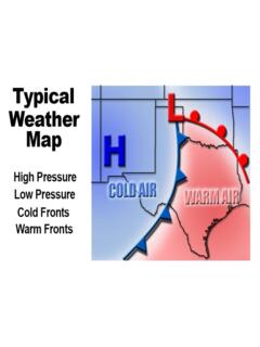
10 The caption with each photograph describes the type and its significance to flight. In closing, we suggest you take a second look at the 62 cloud photographs. Study the descriptions and po-tential hazards posed by each type and learn to use the CLOUDS as "signposts in the sky." Chapter 8 AIR MASSES AND FRONTS Why is weather today clear and cold over Okla-homa while it is warm and moist over Alabama? What caused the line of thunderstorms that you circumnavigated over eastern Arkansas? Air masses and fronts provide the answer. You can better plan the safety and economy of flight when you can evaluate the expected effects of air masses and fronts. This Chapter explains air masses and fronts and relates them to weather and flight planning. AIR MASSES When a body of air comes to rest or moves slowly over an extensive area having fairly uniform properties of temperature and moisture, the air takes on those properties.