Transcription of CHAPTER III. ZONING REGULATIONS - Crescent …
1 CHAPTER III. ZONING REGULATIONS . Applicability. Mapping of districts. Procedures for rezoning. Establishment of districts. Supplemental REGULATIONS . Historic preservation. Applicability. The city of Crescent city is divided into ZONING districts. All lands in the city shall have a ZONING designation and all development shall conform to the standards set forth for the applicable ZONING district and other applicable requirements of this code. Mapping of districts. The boundaries of the various districts are shown on the official ZONING map, which shall be maintained by the city . The map shall be by reference a part hereof. All changes to the district boundaries, as approved by the city commission shall be noted on the map, dated and signed by the development review coordinator.
2 A log shall also be maintained to support the map. The log shall indicate the date of the ZONING and the ordinance adopting the change. The map may be supplemented from time to time by the city commission. Interpretation of district boundaries. Except as otherwise specifically provided, a district symbol or name shown within district boundaries on the official ZONING map indicates that district REGULATIONS pertaining to the district extend throughout the whole area surrounded by the boundary line. Where uncertainty exists as to the boundaries of any district, the following rules shall apply: 1. The boundaries shall be determined by the ordinance establishing the boundaries. 2. Where boundaries are indicated as approximately following street and alley lines, land lot lines, military district lines or lot lines, such lines shall be construed to be such boundaries.
3 3. In unsubdivided property or tracts, where a district boundary divides a lot, the location of such boundaries, unless same are indicated by dimensions, shall be determined by use of the scale of the map. 4. Where the public road, street or alley is officially vacated or abandoned, the REGULATIONS applicable to the property to which it is reverted shall apply to such vacated or abandoned road, street or alley. 5. Where boundaries are so indicated that they are approximately parallel to the centerlines or street lines of streets or to the centerlines of alleys for the centerlines or right-of-way lines of highways, such boundaries shall be construed as being parallel thereto and at such distance therefrom as indicated on the ZONING maps. If no distance is given, such dimension shall be determined from supporting maps or by use of the scale of the map.
4 CC LDC CH 3. 1 of 32. Application of district REGULATIONS . The REGULATIONS herein set out within each district shall be minimum or maximum limitations, as the case may be, and shall apply uniformly to each class or kind of structure or use on land or water, except as hereinafter provided: 1. ZONING affects use or occupancy. No building, structure, land or water shall hereafter be used or occupied, and no building, structure or part thereof shall hereafter be erected, constructed, reconstructed, located, moved or structurally altered except in conformity with the REGULATIONS herein specified for the district in which it is or will be located. 2. Multiple use of required open space prohibited. No part of a required yard or other required open space, required off-street parking or loading space, provided in connection with one building, structure, or use shall be included as meeting the requirements for any other building, structure or use, except as allowed by this code.
5 3. Reduction of lot area prohibited. No lot or yard existing at the effective date of these ZONING REGULATIONS shall thereafter be reduced in size, dimension or area of less than the minimum requirements set out herein, except for public purposes such as road widening. Lots or yards created after the effective date of these ZONING REGULATIONS shall meet at least the minimum requirements established herein. Procedures for rezoning. Any owner, or authorized representative thereof, of a parcel of land desiring to change the ZONING designation of that land may submit an application requesting consideration by the city of the proposed rezoning. Initiation point. Applications for rezoning must be made to the development review coordinator. Submittals and fees. The application shall be a form provided by the city , stating at least: the applicant's name, a legal description and survey of the property, the current ZONING , the requested ZONING , proof of ownership and the reason for the requested change.
6 Appropriate fees shall be paid at the time of submittal. Applications for change to MR-1, PO-1, GC-1 and LI-1 ZONING districts must include a conceptual site plan as described in CHAPTER V. Review process. 1. The development review coordinator shall schedule the application for review by the development review committee and notify all members of the development review committee. The applicant(s) shall be invited to the development review committee meeting. 2. All comments of the development review committee shall be presented to the planning and ZONING commission at a public hearing. CC LDC CH 3. 2 of 32. 3. The planning and ZONING commission shall review the application and the comments of the development review committee and make a recommendation, based on the criteria in subsection , to the city commission.
7 4. All comments and recommendations shall be presented to the city commission at a public hearing. 5. The city commission shall have final authority to approve or deny the request. Review criteria. The city shall consider the following criteria in reviewing applications for rezoning: 1. The need and justification for the change;. 2. The effect of the change, if any, on the particular property and on surrounding properties;. 3. The amount of undeveloped land having the same classifications as that requested in the general area and throughout the city ;. 4. The relationship of the proposed amendment to the purposes of the city 's comprehensive plan, with appropriate consideration as to whether the proposed change will further the purposes of this code and the plan.
8 5. The availability and provision of adequate services and facilities;. 6. The impact on the natural environment; and 7. Other criteria as may be applicable. Restrictions on reconsideration. 1. Whenever the city commission has taken action to deny a petition to rezone property, the city shall not: a. Consider any further petition for the same rezoning of all or any part of the same property for a period of one year from the date of such action;. b. Consider a petition for any kind of ZONING on all or any part of the same property for a period of one year from the date of such action. However, a motion to reconsider the denial may be entertained by the commission. 2. Whenever the city commission has changed the ZONING of any property, the planning and ZONING commission shall not consider any petition for rezoning of all or any part of the same property for a period of six months from the effective date of the amendatory ordinance.
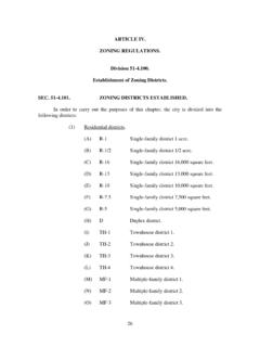
9 CC LDC CH 3. 3 of 32. 3. The time limits of this subsection may be waived by the city commission when such action is deemed necessary to prevent injustice. Establishment of districts. In order to classify, regulate and restrict the uses of land, water, buildings and structures;. to regulate and restrict the height and bulk of buildings; to regulate the area of yards and other spaces around buildings; and to regulate the intensity of land use, the city of Crescent city is divided into the following ZONING districts: TABLE INSET: Land Use Designation ZONING District Symbol Residential- Low Density Single-Family Residential SR-1A. up to 4 DU's Per Acre Dwelling District Residential Low Density Single-Family Residential SR-1. up to 4 DU's Per Acre Dwelling District Residential Medium Multiple-Family Residential MR-1.
10 Density up to 10 DU's Per Dwelling District Acre Commercial Professional Office District PO-1. Commercial General Commercial GC-1. District Industrial District Light Industrial District LI-1. Agricultural Agricultural District AG. Recreational Recreational District REC. Public Buildings and Public Buildings and PF-1. Grounds Grounds District Other Public Facilities Other Public Facilities PF-2. District Conservation Conservation District CON. Historic Resources Historic Resources District HR. Planned Unit Development Planned Unit Development PUD / PD. and/ or Planned Development SR1-A District: Within an SR-1A Single-Family Residential District as shown on the official ZONING Map of the city of Crescent city , the following REGULATIONS shall apply: 1. Permitted uses: a.