Example: dental hygienist
COORDINATE TRANSFORMATIONS IN SURVEYING - …
• Map projections are transformations of geographical coordinates, latitude φ and longitude λ on a sphere or ellipsoid, to rectangular (or Cartesian) coordinates on a plane. • Polar–Rectangular conversions where coordinates of points in polar coordinates, say bearings and distances, are converted to rectangular coordinates.
Tags:
Information
Domain:
Source:
Link to this page:
Related documents
REAL ANALYSIS - Centro de Matemática
www.cmat.edu.uy4 Closed subspaces and orthogonal projections 174 5 Linear transformations 180 5.1 Linear functionals and the Riesz representation the-orem 181 5.2 Adjoints 183 5.3 Examples 185 ... 3.2 Integration formula for polar coordinates 279 3.3 Borel measures on Rand the Lebesgue-Stieltjes in-tegral 281 4 Absolute continuity of measures 285 4.1 Signed ...
Overview of Coordinate Reference Systems (CRS) in R
www.nceas.ucsb.educoordinates An overview of ellipses, datums, and projections The Projection: Project the globe onto a 2D surface There are lots of ways to do each step, resulting in lots of coordinate reference systems. Some common ellipsoid models: Page 2, Melanie Frazier
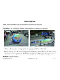
Image Projection - Department of Computer Science ...
www.cs.toronto.educamera coordinates is at the center of projection of the camera (say at d~ w in world coords). The z-axis is taken to be the optical axis of the camera (with points infront of the camera in the positive z direction). • Image coordinate frame, p~. The image coordinates are written as a 3-vector,p~ = (p1,p2,1)T,

Some linear transformations on R2 Math 130 Linear Algebra
mathcs.clarku.eduExample 8 (Projections). Consider the 2 2 matrix 1 0 0 0 . It sends the vector x y to the vector x 0 . This particular transformation is a projection from 2-space onto the x-axis that forgets the y-coordinate. Projections have 1-eigenspaces and 0-eigenspaces. What are they for this projection? This projection will map our leaf to the x-axis as ...
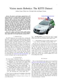
Vision meets Robotics: The KITTI Dataset - Cvlibs
www.cvlibs.netFig. 7. Object Coordinates. This figure illustrates the coordinate system of the annotated 3D bounding boxes with respect to the coordinate system of the 3D Velodyne laser scanner. In z-direction, the object coordinate system is located at the bottom of the object (contact point with the supporting surface).

The mathematics of sundials - ed
files.eric.ed.govThe coordinates of P can be found by solving simultaneously the equations for GP and OP. The angle Z(the Sun’s azimuth) that the shadow of a vertical gnomon makes with the north–south line depends on the latitude, the time of day and the declination of the Sun, which changes through the day and through the year.

The LAS file format contains a header block ... - ASPRS
www.asprs.orgX, Y, or Z coordinate. For example, if the X, Y, and Z coordinates are intended to have two decimal point values, then each scale factor will contain the number 0.01. X, Y, and Z offset: The offset fields should be used to set the overall offset for the point records.