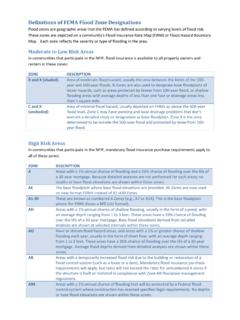
Transcription of ELECTROMAGNETIC METHODS - GEOVision
1 ELECTROMAGNETIC METHODS ELECTROMAGNETIC (EM) METHODS include frequency domain EM METHODS , such as EM induction, EM utility locator/metal detection METHODS , very low frequency (VLF) EM, and controlled source audio-frequency magnetotellurics (CSAMT), as well as time domain EM METHODS (TDEM). GEOV ision geophysicists have successfully utilized a wide variety of EM METHODS for hydrogeologic, engineering, and environmental investigations. Geonics EM-31 Terrain Conductivity Meter Geonics EM-31 Survey to Locate Underground Storage Tanks EM Induction Method EM induction and EM utility location are the most common EMtechniques applied to shallow engineering and environmentalinvestigations.
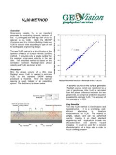
2 EM induction surveys are often conducted usingthe Geonics EM-31, EM-34, and EM-38 terrain conductivity meters and the GSSI GEM300 multi-frequency EM system. The EM-31 consists of a transmitter coil mounted at one end and a receivercoil mounted at the other end of a long plastic boom. Electrical conductivity and in-phase field strength are measured and stored along with line and station numbers in a digital data logger. The EM-31 can explore to depths of about 6 meters, but is most sensitive to materials about 1 meter below ground EM-38 has a 1-meter coil spacing and is designed for characterizing the upper meters.
3 The EM-34 consists of a large transmitter and receiver coil connected by a reference cable. Itmeasures conductivity at coil separations of 10, 20, or 40 metersand is used for exploration to depths up to 60 meters. VLF EM METHODS GEOV ision typically conducts EM induction surveys to: Locate buried tanks and pipes Locate pits and trenches containing metallic and/or nonmetallic debris Delineate landfill boundaries Delineate oil production sumps and mud pits Map conductive soil and groundwater contamination Map soil salinity in agricultural areas Characterize subsurface hydrogeology Map buried channel deposits Map geologic structure Groundwater exploration Locate conductive fault and fracture zonesEM Utility Location Method EM utility locators are used for tracingmetallic pipes and utility cables andclearing drilling
4 And excavation utility locators consist of a separatetransmitter and receiver. The transmitteremits a radio frequency EM fieldthat induces secondary fields in nearby metallicpipes and cables. The receiver detectsthese fields and accurately locates andtraces the pipes, often to distances over200 feet from the transmitter. Modern utilitylocators are also capable of providingapproximate depth estimates of the pipesand sweeping areas for 60 Hz signalemanating from electrical lines. Metrotech Utility Locator Geonics EM-31 Survey to Map Mud Pits VLF surveys measure various components of the VLF EM fields in the frequency range of 15 to 25 kHz.
5 These low frequency EM fields are generated by submarine communications stations scattered around the world. Long linear conductors give rise to localized anomalies in these VLF fields, which make the VLF method an effective tool for mapping conductive fault and fracture zones, especially water-bearing fracture zones in hard rock environments. CSAMT and TDEM METHODS CSAMT and time-domain ELECTROMAGNETIC (TDEM) surveys are conducted to map changes in resistivity or its inverse, conductivity, with depth. These METHODS are, in effect, the EM equivalents of the resistivity sounding method.
6 CSAMT and TDEM soundings can be made at stations along a profile to yield two-dimensional information on the resistivity structure of the subsurface. TDEM METHODS also include the Geonics EM-61, designed specifically to locate buried metallic objects such as drums, tanks, pipes, UXO, and buried debris. GEOV ision uses CSAMT and TDEM METHODS to: Locate buried metallic objects/debris Map geologic structure Map large fracture zones Map deep conductive contaminant plumes such as oil fieldbrines and acid-mine drainage Map salt-water intrusion Determine depth to groundwater and groundwater resources Map subsurface stratigraphy Geonics EM-61 Digital Metal Detector (EM-61) CSAMT and TDEM data are generally modeled using computer inversion techniques, and output is a model of resistivity as a function of depth.
7 These techniques can be used to explore depths ranging from about 30 feet to over 5,000 feet, depending on methodology used. 1151 Pomona Road, Unit P, Corona, California 92882, ph. 909-549-1234, fx. 909-549-1236, Geonics TDEM System 20 Geonics EM-34 and TDEM Survey Map Horizontal and Vertical Extent of Brine Contamination EM-61 Survey to Map Subsurface Infrastructure 050100150(feet)AA BB EM-34 STATIONLOCATIONSEM-47 SOUNDINGLOCATIONS145406080 BRINEPOND23406080 Contour Interval: 20 millisiemens per meterTDEM Sounding to Map Depth to Groundwater and Bedrock 2(500)8 Resistivity, Ohm-meters(125) Conductivity, Millisiemens per meter050100150(feet)