Transcription of EOD Lesson Plan 1 Intro to Google Earth 6-8 Grade
1 Lesson Plan 1 introduction to Google Earth for Middle and High School 1 A Google Earth introduction to Remote Sensing Image an image is a representation of reality. It can be a sketch, a painting, a photograph, or some other graphic representation such as satellite data. Satellites capture and store electromagnetic waves that are reflected or emitted from features on the Earth , somewhat like a camera. Remote Sensing remote sensing can be defined as the scientific and technical discipline that involves acquiring information of various Earth features from a distance. Sometime the distance is great, such as satellite-based remote sensing where the satellites are in orbit high above the Earth ; other times the distance is much less, such as aircraft-based remote sensing where the airplane is much closer to Earth .
2 Geographic Information System (GIS) GIS can defined as the technical discipline that uses computer-based (digital) geospatial data to map and model geographic information. Geographic Information Systems are composed of computer hardware, software, geospatial data (which we ll define shortly, so don t worry), and a person to operate the system. Geospatial Data data that has geographic location information associated with it. Learning Objectives: Upon successful completion of this lab, students will be able to: Navigate around the world using Google Earth Define Remote Sensing and GIS Understand the basics of digital geospatial data This exercise was developed using Google Earth Version introduction to Google Earth Teacher Prep time: Depends on the teacher s experience with Google Earth .
3 One hour is required for those who are new to Google Earth . Fifteen minutes is required, to review the Lesson , for those with a working knowledge of Google Earth . Class Time Requirement: 50 minutes Materials needed: Windows or Mac computer with Internet connection and Google Earth or higher installed. Teacher Prep Instruction: Unblock Google Earth for your class, if needed (talk to your IT personnel). Go to the following website to familiarize yourself with the content - Lesson Plan 1 introduction to Google Earth for Middle and High School 2 Classroom Instructions: 1.) Start Google Earth by double-clicking the Google Earth Icon or browse the icon in the Start menu.
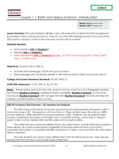
4 This will start the program. The entire Earth (as a globe) will be shown by default. 2.) Close Start-Up-Tip and start to explore and familiarize yourself with the Google Earth main menu on the top left on your screen, below in Figure 1. Figure 1. The Google Earth main menu (windows based). 3.) Windows-based: Click on Tools , select Options and note the five tabs across the top of the Options box. Mac-based: Under the Google Earth main menu select Preferences In the 3D View tab in the Terrain box near the bottom, set Elevation Exaggeration to 3 , as shown below in Figure 2. Click Apply to close the box. This will exaggerate the elevation relief by a factor of 3.
5 Figure 2. Google Earth Options 3D View tab with Terrain Elevation Exaggeration circled in red. Hint: Before you begin using the navigation tools, make sure that the Borders and Labels layer is showing and checked. This will add country, state, and county borders and other information to the screen. To show the Borders and Labels, check the Layers panel on the lower left hand side of the screen as shown in Figure 3. Lesson Plan 1 introduction to Google Earth for Middle and High School 3 Figure 3. The Borders and Labels information in the Layers menu on the lower left side of the screen. Now that we have geospatial references (the technical term for borders and labels ) to help navigate, we ll begin to use Google Earth by creating and editing a Placemark of your house.
6 5.) Use the navigation tools on the upper right hand side on the screen to navigate to your house. These tools will allow you to zoom in and out of a location, change your cardinal orientation within a location, and pan across the map. Figure 4. Screenshot showing the navigation tools on the map. This is typically the first thing that new Google Earth users do. Navigating to your house can be done either by using the pan tool and dragging on the Earth while using the mouse and the scroll button or you can enter the address in the search bar on the upper left hand side of the screen. Zoom in all the way by double clicking the image or pulling the zoom slider all the way up until the image becomes fuzzy.
7 Navigation Tools, incl. pan tool Lesson Plan 1 introduction to Google Earth for Middle and High School 4 Figure 5. Option to enter the address in search box Hint: If you notice that features such as new buildings, houses, or roads are missing on Google Earth , it is the images are older than the new features. Mapping systems like Google Earth require constants updates. If the images are not updated frequently, the data becomes out of date, especially in areas that are experiencing rapid changes in land cover ( development , in the case of new buildings, houses, and roads). 6.) Once you locate your house, click on the Placemark icon, the yellow pushpin circled in red in the icon menu on the upper left corner of the map, shown in Figure 6.
8 Figure 6. The Google Earth icon menu, showing the yellow pushpin Placemark icon. 7.) Click on the Placemark , opening a window called New Placemark . Drag the yellow pin (placemark) over your house. Now change the Name My House in the new placemark window. Click the OK button to close the New Placemark box. Hint: You can add a description of your house in the Description box. You can also change the color and type of Placemark, as well as the View and Altitude of the Placemark. You can also read and edit the information in the Placemark box at any time. To do so, using the mouse, right-click on the Placemark and draw down to Properties , then left-click.
9 This will open the Placemark box, allowing editing of the Placemark s attributes. Figure 7. Setting the yellow pin Placemark at your houses location. Lesson Plan 1 introduction to Google Earth for Middle and High School 5 Where is your house located? One way to answer is this question is to provide an address (for example, 123 Main St. Newtown, USA 54321). Another is to provide the geographic coordinates of your house. Record the Latitude, Longitude and Elevation of your house. Lat_____ Long_____ Elevation_____ What is the topography of your town? Use the navigation tools to change the angle of your perspective from looking straight down, to looking sideways, called an oblique perspective.
10 My town s topography is _____ (flat, hilly, rolling, etc.). What is the most descriptive term that describes your town s topography? Now that you ve had a chance to play with Google Earth and locate your house and explore the topography, let s explore the data Google Earth uses. First, let s define a few terms that will be useful as we progress. Remotely sensed images are comprised of many square cells called pixels (pixel stands for picture element , one element of a picture). Each pixel is shown on the computer screen using a single color. In addition, in Google Earth or in a Geographic Information System, each pixel has a geographic location (your house was shown using pixels, right?)