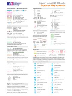
Transcription of Explorer Explorer Map symbols
1 Explorer series (1:25 000 scale). Explorer Map symbols ROADS AND PATHS Not necessarily rights of way GENERAL FEATURES. M1 or A6(M) Junction Gravel pit Y Triangulation pillar Motorway Service Area Number A 35. Dual carriageway Sand pit t Mast A 31(T) or A35 Trunk or Main road Windmill; with or without sails Other pit B 3074 Secondary road or quarry E ( Wind pump; wind generator Narrow road with passing places Landfill site pylon pole Electricity transmission line Road under construction or slag heap Slopes Road generally more than 4 m wide Current or with tower Road generally less than 4 m wide former Place with spire, minaret, of worship or dome BP Boundary post Other road, drive or track, fenced and unfenced Place of worship BS Boundary stone Gradient: steeper than 20% (1 in 5) CH Clubhouse 14% (1 in 7) to 20% (1 in 5) Building; important building FB Footbridge Ferry Glasshouse (V) Vehicle; (P) Passenger MP; MS Milepost.)
2 Milestone Path Youth hostel Mon Monument Bunkhouse/camping barn/ PO Post office selected areas only other hostel (selected areas only) Pol Sta Police station RAILWAYS Sch School Bus or coach station TH Town Hall Multiple track Single track Standard gauge ? Lighthouse; disused lighthouse; NTL Normal tidal limit Narrow gauge : Beacon W; Spr Well; spring Light Rapid Transit System with station HEIGHTS AND NATURAL FEATURES VEGETATION. Road over; road under; level crossing 52 Ground survey height Vegetation limits are defined by positioning of symbols Cutting; tunnel; embankment 284 Air survey height Station, open to passengers; siding Coniferous trees Surface heights are to the nearest metre above mean sea level.
3 Heights shown close to a triangulation pillar refer to the ground level height at the pillar and not Non-coniferous trees PUBLIC RIGHTS OF WAY Not shown on maps of Scotland necessarily at the summit Vertical face/cliff Coppice Footpath Bridleway 75 Orchard 60. Byway open to all traffic Scrub 50. Road used as a public path Loose Boulders Outcrop Scree rock Bracken, heath or rough grassland The representation on this map of any other road, track or path is no evidence of the existence of a right of way Water Mud Marsh, reeds or saltings. OTHER PUBLIC ACCESS Sand; sand and shingle Other routes with public access The exact nature of the rights on these routes and the existence ACCESS LAND.
4 Of any restrictions may be checked with the local highway authority. Alignments are based on the best information available. Access land boundary and tint DANGER AREA MANAGED. ACCESS. National Trail / Long Distance Route;. Recreational route Access land in wooded area Firing and test ranges in Access permitted within Permitted footpath See note below the area. Danger! managed controls, for Permitted bridleway Access information point Observe warning notices example, local byelaws Footpaths and bridleways along which landowners have permitted public Portrayal of access land on this map is intended as a guide to land which is normally available for access on foot, for example use but which are not rights of way.
5 The agreement may be withdrawn. access land created under the Countryside and Rights of Way Act 2000, and land managed by the National Trust, Forestry Commission and Woodland Trust. Access for other activities may also exist. Some restrictions will apply; some land will be excluded from open access rights. The depiction of rights of access does not imply or express any warranty as to its accuracy or Off road cycle routes completeness. Observe local signs and follow the Countryside Code. BOUNDARIES TOURIST AND LEISURE INFORMATION. National Building of historic interest Nature reserve County Cadw (Welsh heritage) National Trust property Constituency (Const), Electoral Region (ER) or Burgh Const Camp site Other tourist feature Civil Parish (CP) or Community (C).
6 Unitary Authority (UA), Caravan site Parking Metropolitan District (Met Dist), London Borough (LB) or District Camping and caravan site Park and ride, all year / seasonal National Park Castle / fort Picnic site Cathedral / Abbey Preserved railway ARCHAEOLOGICAL AND HISTORICAL INFORMATION. Country park Public Convenience Site of antiquity 1066 Site of battle (with date) Cycle trail Public house/s Roman English Heritage property Recreation / leisure / sports centre Non-Roman Visible earthwork Fishing Slipway Telephone (public / motoring Forestry Commission visitor centre organisation / emergency). NB. Due to changes in specification there are Garden / arboretum Theme / pleasure park differences on some sheets Golf course or links Viewpoint Ordnance Survey, OS and the OS Symbol are registered trademarks, and Explorer is a trademark of Ordnance Survey, the national mapping agency of Great Britain.
7 Information centre Visitor centre Information centre, seasonal National Park Information Point Made, printed and published by Ordnance Survey, Southampton, United Kingdom. For educational use only. Horse riding Walks / trails September 2004 Crown copyright 2004. All rights reserved Museum Water activites