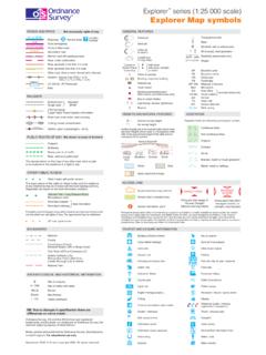
Transcription of Explorer Explorer Map symbols - mkbartlett.co.uk
1 Road generally more than 4 m widePathTrunk or Main roadSecondary roadDual carriagewayMotorwayRoad generally less than 4 m wideOther road, drive or track, fenced and unfencedNot necessarily rights of wayROADS AND PATHSS ervice AreaJunctionNumberM1 or A6(M)A 31(T) or A35B 3074A 35(V) Vehicle; (P) PassengerFerryNarrow road with passing placesRoad under constructionGradient: steeper than 20% (1 in 5)14% (1 in 7) to 20% (1 in 5)GENERAL FEATURES with towerwith spire, minaret,or domeCurrent orformer Placeof worshipBuilding; important buildingGlasshouseBus or coach stationLighthouse; disused lighthouse;Youth hostelBunkhouse/camping barn/other hostel (selected areas only)Landfill siteor slag heapSand pitGravel pitOther pitor quarryElectricity transmission lineTriangulation pillarpylonpoleWindmill; with or without sailsWind pump; wind generatorSlopesBPBSCHFBMP; MSMonPOPol StaSchTHBoundary postBoundary stoneClubhouseFootbridgeMilepost; milestoneMonumentPost officePolice stationSchoolTown HallNormal tidal limitWell; springW.
2 Sprselected areas onlyNTLV egetation limits are defined by positioning of symbolsConiferous treesNon-coniferous treesCoppiceOrchardVEGETATIONS crubMarsh, reeds or , heath or rough grasslandWaterSand; sand and shingleGround survey heightAir survey height52284 Surface heights are to the nearest metre above meansea level. Heights shown close to a triangulation pillarrefer to the ground level height at the pillar and notnecessarily at the summitHEIGHTS AND NATURAL FEATURESMud607550 LooserockOutcropVertical face/cliffBouldersScreeTOURIST AND LEISURE INFORMATIONPUBLIC RIGHTS OF WAYF ootpathBridlewayByway open to all trafficRoad used as a public pathThe representation on this map of any other road, track or pathis no evidence of the existence of a right of wayNot shown on maps of ScotlandStation, open to passengers.
3 SidingMultiple trackSingle trackNarrow gaugeLight Rapid Transit System with stationStandardgaugeCutting; tunnel; embankmentRoad over; road under; level crossingRAILWAYSR ecreational routeOTHER PUBLIC ACCESSO ther routes with public accessThe exact nature of the rights on these routes and the existenceof any restrictions may be checked with the local highway are based on the best information footpathPermitted bridlewayFootpaths and bridleways along which landowners have permitted publicuse but which are not rights of way.
4 The agreement may be road cycle routesSee note belowNational Trail / Long Distance Route;BeaconMast:?tYE(Site of antiquitySite of battle (with date)ARCHAEOLOGICAL AND HISTORICAL INFORMATIONR omanNon-RomanVisible earthwork1066 BOUNDARIESN ationalUnitary Authority (UA),Metropolitan District (Met Dist),London Borough (LB) or DistrictCivil Parish (CP) or Community (C)Constituency (Const),Electoral Region (ER) or Burgh ConstNational ParkCountyPlace of worshipExplorer series (1:25 000 scale) Explorer Map symbolsNB. Due to changes in specification there aredifferences on some sheetsOrdnance Survey, OS and the OS Symbol are registeredtrademarks, and Explorer is a trademark of Ordnance Survey, thenational mapping agency of Great , printed and published by Ordnance Survey, Southampton,United Kingdom.)
5 For educational use 2004 Crown copyright 2004. All rights reservedACCESS LANDF iring and test ranges inthe area. Danger!Observe warning noticesDANGER AREAP ortrayal of access land on this map is intended as a guide to land which is normally available for access on foot, for exampleaccess land created under the Countryside and Rights of Way Act 2000, and land managed by the National Trust, ForestryCommission and Woodland Trust. Access for other activities may also exist. Some restrictions will apply; some land will beexcluded from open access rights.
6 The depiction of rights of access does not imply or express any warranty as to its accuracy orcompleteness. Observe local signs and follow the Countryside land boundary and tintAccess land in wooded areaAccess information pointAccess permitted withinmanaged controls, forexample, local byelawsMANAGEDACCESSP ublic ConvenienceWater activitesBuilding of historic interestCadw (Welsh heritage)Caravan siteCastle / fortCathedral / AbbeyCountry parkCycle trailEnglish Heritage propertyFishingGarden / arboretumGolf course or linksInformation centreHorse ridingNature reserveOther tourist featureParkingPicnic sitePreserved railwayPublic house/sRecreation / leisure / sports centreTelephone (public / motoringorganisation / emergency)
7 Theme / pleasure parkSlipwayViewpointVisitor centreWalks / trailsForestry Commission visitor centreNational Trust propertyMuseumCamp siteInformation centre, seasonalCamping and caravan siteNational Park Information PointPark and ride, all year / seasonal650600 Ferry PFerry VA 493B 4518B 885A 855S1M1L:50144tE(WVVV[]{X\` lA 470 LCaoNot necessarily rights of wayROADS AND PATHSE levatedJunction numberService areaFootbridgeUnfencedDual carriagewayBridgePrimary RouteMotorway (dual carriageway)Motorway under constructionMain roadPrimary Route / Main road under constructionSecondary roadNarrow road with passing placesRoad generally less than 4m widePath / Other road, drive or trackGradient.)}
8 20% (1 in 5) and steeper,14% (1 in 7) to 20% (1 in 5)Gates / Road TunnelFerry (passenger) / Ferry (vehicle)Road generally more than 4m wideRAILWAYSL evel crossingBridges / FootbridgeTunnelTrack multiple or singleTrack under constructionLight rapid transit system,narrow gauge or tramwayStation, (a) principalWATER FEATURESB ridgeCanalTowpathAqueductLakeWeirNormal tidal limitFootbridgeCanal (dry)CliffSlopesMarsh or saltingLockFlat rockSandDunesFordMudShingleBeaconLightho use(in use)Lighthouse(disused)LowwatermarkHighw atermarkHEIGHTS1 metre = feetROCK FEATURESC ontours are at 10 metresvertical intervalHeights are to the nearestmetre above mean sea levelHeights shown close to a triangulation pillarrefer to the ground at the base of the pillarand not necessarily to the woodNon-coniferous woodMixed woodOrchard / Park or ornamental groundQuarrySpoil heap, refuse tip or dumpNational Trust-always openNational Trust for ScotlandForestry Commissionaccess landNational Trust-limited access.
9 Observe local signsWind pump / wind generatorChimney or towerGlass structureGraticule intersection at 5 intervalsHeliportTriangulation pillarWindmill with or without sailsMastPlace ofworshipwith towerwith spire, minaret or domewithout such additionsElectricity transmission line(pylons shown at standard spacing)Pipe line(arrow indicates direction of flow)BuildingsPublic building (selected)Bus or coach stationLAND FEATURES ruinOS Landranger (1:50 000 scale)Map symbolsSidingLight rapid transit systemstationViaductCutting / OTHER PUBLIC ACCESSPUBLIC RIGHTS OF WAYO ther route with public access(not normally shown in urbanareas).
10 Alignments are based onthe best information routes are not shown onmaps of Trail, European LongDistance Route, Long DistanceRoute, selected RecreationalRoutesNational/Regional Cycle NetworknumberNational/Regional Cycle NetworkSurfaced cycle routeThe symbols show the defined route so faras the scale of mapping will allow. Rights ofway are not shown on maps of representation on this map of any otherroad, track or path is no evidence of theexistence of a right of wayFiring and Test Ranges inthe area. Danger!Observe warning used as a public pathBridlewayByway open to all trafficBOUNDARIESANTIQUITIESD istrictNationalCounty, Unitary Authority,Metropolitan Districtor London BoroughNational ParkRomanNon-RomanBattlefield (with date)