Transcription of Sponsored by k - Home | Scouts
1 1 Sponsored GUIDE TO THE NAVIGATOR BADGEFOR SCOUTLEADERS2 CONTENTSWELCOME 3 ORDNANCE SURVEY MAPS 4 FINDING NORTH 6 map symbols 9 CONTOUR LINES 9 TOPOGRAPHICAL FEATURES 10 SETTING A MAP 11 MAP REFERENCES 12 MAP DISTANCES AND TIMING 13 UNDERSTANDING TRAFFIC SIGNS AND SIGNALS 14 NAVIGATING OUR ROADS 16 THE PRACTICAL USE OF A COMPASS 17 FURTHER INFORMATION 2023In today s world young people undertake a wide variety of journeys. These range from travelling to and from school, visiting relatives, holidays abroad and, of course, Scout nights away! Many things that young people come into contact with have also made long journeys for example, food, clothing and electronics. Navigation and exploration are exciting and dynamic topics that can take Scouts out of their meeting place and into local communities coming into contact with new environments via new are all natural explorers; from the moment of birth we begin to navigate our surroundings.
2 First we become familiar with our own environment, we then begin to explore other places and form perceptions beyond our direct experience. Navigation is an essential skill that will help young people to place themselves in the world. Much of the Scout Navigator Badge centres on reading and understanding maps and navigating a variety of routes using a number of techniques. Knowing how to interpret maps and navigate is a skill that will enhance the confidence and knowledge of Scouts to make journeys safely and further prepare them for the various terrains and effectively allows us to make the most of a particular area and allows us to discover new surroundings. Ordnance Survey produces a wide range of maps, differing in scales, that can be used for a number of outdoor and adventurous resource is a practical guide, based on Alternative A, intended to help you work through the Scout Navigator Badge with your Troop and links closely with the resource for young people, created by Ordnance Survey s MapZone , There are a number of opportunities throughout this resource when MapZone can be used as material for your ARE FOUR ASPECTS TO THIS AWARD:1.
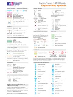
3 Using 1:25 000 and 1:50 000 scale Ordnance Survey Understanding traffic signs and Navigating our The practical use of a each aspect, we ve provided some background knowledge, some things to think about, things to do and things to discuss. You ll also find some useful contacts listed at the back of this resource. Please think creatively about how you will approach this Activity Badge it doesn t need four weeks to complete the four steps. There are a variety of methods that you can use to successfully deliver this luck and have fun! Please do get in touch with the Scout Section Office at Gilwell or phone 0845 300 1818 and let us know how you get by:Peter Oliver and Peter Evans4 ORDNANCE SURVEY MAPSUSING 1:25 000 AND 1:50 000 SCALE ORDNANCE SURVEY MAPS: Show that they understand the meaning of scale, true, grid and magnetic north and can recognise conventional map symbols .
4 Interpret contour lines in terms of shape and steepness of terrain. Know the meaning of topographical features such as valley, col, ridge, spur and so on. Show how to set a map with and without a compass. Be able to use and to give six-figure grid references. Demonstrate the use of a Romer to improve accuracy. Show how to measure distances on a map and how to estimate timings for a particular route. Show how to find north without the aid of a compass, by day or night. Demonstrate their awareness of the latest developments in electronic technology such as the Global Positioning section of the badge expects Scouts to show an in-depth understanding of Ordnance Survey maps, ranging from understanding scale and contour lines to various topographical features. It would be advisable to obtain several Ordnance Survey maps (the Explorer range is ideal) of your local area or the area where you regularly camp with the Scouts , as this will allow them to appreciate how physical landmarks are represented and also will allow them to visualise the landscape shown on the map scalesBefore the Scouts can begin to use an Ordnance Survey map, they need to understand its scale.
5 All maps are drawn to scale, which means there is a direct relationship between distances measured on the ground and distances measured on the maps, usually shown by the scale bar on the map. When reading a map, the first thing you should do is establish the scale; it is normally expressed as a ratio, such as 1:25 000. This means that 1 unit of measurement on the map is equal to 25 000 of the same units of measurement on the ground. At right is a table comparing the two main scales that would be used by Scouts for walking and so :25 000 SCALEMaps at a scale of 1:25 000 are sometimes called medium-scale maps. One centimetre on a 1:25 000 scale map is equal to 25 000 centimetres (or 250 metres kilometre) on the ground; four centimetres on the map therefore represents one kilometre on the ground. Therefore, two and a half inches on the map is equal to one mile on the 1:25 000 scale, major buildings or landmarks are clearly visible; other features such as field boundaries and walls also appear.
6 At this scale no road names or smaller details are at 1:25 000 scale are used by walkers and other outdoor enthusiasts but they also contain enough detail for local area planning :50 000 CALEMaps at a scale of 1:50 000 are small-scale centimetre on a 1:50 000 scale map is equal to 50 000 centimetres (or 500 metres kilometre) on the ground; four centimetres on the map therefore represents two kilometres on the ground (2 cm = 1 km). Therefore, one and a quarter inches on the map is equal to one mile on the 1:50 000 scale, major buildings may be shown in some detail, if they are large enough. Individual buildings are no longer shown, they become blocked together. Field boundaries will no longer appear. Maps at 1:50 000 scale are used for general-purpose use, for example, business planning, motoring, walking and Using 1:25 000 and 1:50 000 scale Ordnance Survey get your Scouts to understand scale by getting them to draw two maps to different scales of your meeting place (as any larger map would prove to be difficult).
7 Give them the dimensions of the hall/building and ask them to include some of the internal features, for example, toilets, stages, side rooms and so on. Obtain two Ordnance Survey maps of the same geographical location but to different scales. This will allow the Scouts to appreciate the difference between the two. An idea would be to get the Scouts to construct a table discussing the advantages and disadvantages and situations where they could use each :25 000 scale map Crown copyright1:50 000 scale map Crown copyright1. Using 1:25 000 and 1:50 000 scale Ordnance Survey IS NORTH?There are actually three norths1. True northThis is the celestial north, which is obtained from readings taken from the sun or the stars. This can be found by knowing how to identify constellations in the sky or by using the shadows caused by the sun, and their movement throughout the day to obtain a northern direction.
8 Along with this, for a very rough estimate or a northern direction we can simply be aware that the sun itself rises in the east and sets in the your watch to find north from the position of the sunIf you have a wristwatch where the hands go round the face, you can use it to locate north. The sun is always due south at true midday in the northern hemisphere. By true midday we mean Greenwich Mean Time (GMT), so if you are in British Summer Time, you will need to take an hour off the actual time. Point the hour hand towards the sun. If it is after am or before pm, south lies midway in the smaller angle between the hour hand pointing at the sun and 12. If it is before am or after pm, south is found by dissecting the wider angle. It is then an easy matter to locate people wear digital watches these days, but if you carefully draw an analog face on a piece of paper, and mark off the position of the hour hand from your digital watch, then the technique is exactly the same as described Stick methodDrive a (straight) stick into the ground as near vertically as possible and mark the tip of its shadow with a stone or at least 15 minutes and mark the tip of the new shadow, in a similar line from the first marker, running through the second, will, in the northern hemisphere, point roughly east.
9 This means that the north-south line is at a right angle to this, with north pointing away from the is most accurate towards the middle of the NORTH WITH AND WITHOUT A COMPASSABSN1. Using 1:25 000 and 1:50 000 scale Ordnance Survey a clear night when the stars can be seen clearly, it is possible to identify the Pole Star (Polaris) that appears almost exactly over the north. The Pole Star sits at the end of Ursa Minor (the Little Dipper) and most people locate it by finding The Plough (Ursa Major) and using the end two stars on the blade of The Plough as pointers. The centre of Cassiopeia, the big W, also points towards natural indicatorsPlants and trees may also be used to give an indication of direction. As we are in the northern hemisphere, our flowers and plants will have more growth in the direction of the sun so where the majority of the growth is will be a southern direction.
10 Also, if you are aware of the area s most frequent wind direction, this can be used, as winds blowing from a south-east direction will cause the branches to grow in a north-west Using 1:25 000 and 1:50 000 scale Ordnance Survey Grid northThis is the direction of north shown on maps, from which a map bearing would be taken. Along with this, on most Ordnance Survey maps the grid north is identified in the legend on the map itself. It should also be noted that all Ordnance Survey maps are printed so that north is at the top of the map!Activity ideas While on a camp encourage your Scouts to find north using the sun during the day and attempt to find the north star on a clear night; most city skies will not allow this due to light pollution. Along with this, while on camp, allow the Scouts some time to study the natural environment to see if there are any indicators present as to which way is north.