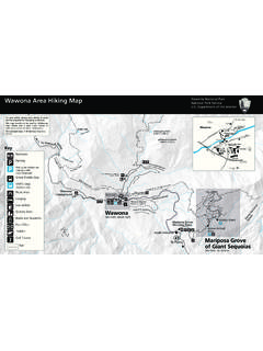
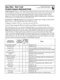
Transcription of Glacier Point Area Hiking Map - NPS
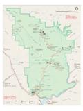
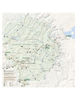
1 Mi ( km) mi ( km) mi ( km) mi ( km) mi ( km) mi ( km) m i ( km) mi ( km) mi ( km) mi ( km) mi ( km) mi ( km) mi ( km) mi ( mi) mi ( km) mi ( km) mi ( km) mi ( km) mi ( km) mi ( km) mi ( km) mi ( km) mi ( km) mi ( km) mi ( km) mi ( km) mi ( km) mi ( km) mi km mi ( km)WawonaEl PortalcablesParking AreaTelephoneStoreRanger StationCampgroundRestrooms1 Kilometer1 MileNorthRoadTrail(permitrequired) This map should not be used for wilderness trips; use a detailed trail map or topographic map instead. Always be prepared for sudden changes in weather and carry plenty of water. Treat all water obtained from natural sources. Stay on the trail; taking a shortcut causes trail erosion and can be dangerous.
2 Never feed or approach wildlife!Yosemite Ski and Snowboard AreaBridalveil CreekOstrander Lake8500ft2590mDewey Point7385ft2251mStanfordPointCrockerPoin tTaft Point7503ft2287mSentinelDome8122ft2476mH alfDome8836ft2693mWashburnPointSentinel Dome& Taft PointTrailheadMonoMeadowTrailheadOstrand er LakeTrailheadMcGurk MeadowTrailheadTunnelView7214ft2199mBrid alveil CreekCampgroundOpen July early Yosemite Valley6100ft1859mToClouds kmIllilouette CreekEdson Lake8145ft2483mHart Lakes8717ft2657mLower Merced Pass Lake8820ft2688mGrayling Lake8692ft2650mMerced RiverMerced RiverMcGurkMeadowMonoMeadowWestfallMeado wLost BearMeadowWawona TunnelF o r Yo s e m i t e Va l l e y t r a i l s a n d i n f o r m a t i o n ,p l e a s e s e e t h e Yo s e m i t e Va l l e y H i k i n g M a p.
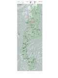
3 Glacier Point RoadGlacier Point Roadclosed November Mayeast of the ski FallVernal FallNevada FallIllilouette FallCrane FlatBunnellPointMt. Starr King9092ft2771mH o r i z o n R i d g eI l l i l o u e t t e R i d g eEmpireMeadowG ro u s e C r e e kChinquapinWawona RoadHappy IslesTrailheadInspirationPointFour MileTrailheadPohono TrailBig Oak Flat RoadEl Portal RoadRooseveltPoint7380ft2250mGlacier Point12041140 Glacier Point Area Hiking MapYosemite National Park National Park Department of the InteriorGlacier Point Area Hiking Map*Yosemite National Park National Park Department of the Interior Easy Glacier Point 300 yards one way. 5 minutes. Begin at Glacier Point parking areaCome for the sunrise or stay for the sunset the view from Glacier Point is spectacular any time of day.
4 Start at the Glacier Point parking area and enjoy a leisurely wheelchair-accessible stroll to the Glacier Point railing, where you look down on Yosemite Valley (3,200 below!) and east toward Half Dome and the High Sierra. McGurk Meadow miles ( km) round-trip. 1 2 hours; 150 ft (50 m) elevation change Begin at McGurk Meadow trailheadThe trail leads downhill mile ( km) to McGurk Meadow and the site of an old cabin that belonged to shepherd John McGurk. During early summer, look for a tremendous show of wildflowers. You can continue along the trail an additional mile ( km) to reach the Pohono Trail, which runs west to Dewey Point and Tunnel view and east to Bridalveil Creek, Taft Point , and Glacier Point .
5 Moderate Dewey Point miles ( km) round-trip. 4 6 hours; 750 ft (225 m) elevation change Begin at McGurk Meadow trailheadBegin by following the McGurk Meadow trail as described above. Continue one mile ( km) past the meadow to reach an intersection with the Pohono Trail. Follow the Pohono Trail west (left) to Dewey Point , miles ( km) from the trailhead. Enjoy the unique views of El Capitan, Cathedral Rocks, Half Dome, and the Yosemite high country. Return the same way, or you can continue on the Pohono Trail west to more viewpoints and eventually the Tunnel view parking area miles ( km) beyond Dewey Point & The Fissures miles ( km) round-trip. 2 hours (200 ft (60 m) elevation change) Begin at Sentinel Dome/Taft Point trailheadBegin with an easy walk through the forest past a wildflower-filled meadow (seasonal), the trail leads to an expanse on the south rim of Yosemite Valley.
6 Taft Point is marked by a small railing at the cliff s edge. Enjoy magnificent views of Yosemite Valley, including El Capitan and Yosemite Falls. Near Taft Point , you ll see the Fissures narrow fractures in the granite called joints. Watch out for drops near these fractures of up to 2,000 feet!Sentinel Dome miles ( km) round-trip. 2 hours; 400 ft (125 m) elevation change Begin at Sentinel Dome/Taft Point trailheadThis wide trail leads mostly across open granite with little shade. The trail meets an old road near the base of Sentinel Dome. Follow the road to the northeast side of the dome where the incline is less imposing. From here, scramble up the granite slope to the top of the dome.
7 Enjoy a breathtaking 360-degree view of the park. Consider taking this hike at sunset or during a full moon, but remember to bring a flashlight with fresh batteries!Sentinel Dome/Taft Point Loop miles ( km) loop. 3 4 hours; 1,000 ft (300 m) elevation change. Begin at Sentinel Dome/Taft Point trailheadThe Sentinel Dome and Taft Point trails can be combined into a loop hike. For a counterclockwise loop, start by Hiking Sentinel Dome s northeast side as described previously. After descending the same northeast slope, follow the trail north to the Pohono Trail junction. Take the Pohono Trail southwest, descending to Sentinel Creek before climbing to the Taft Point trail junction. From here, Taft Point sits a half mile downhill to the west (right), while the trailhead is a half mile to the east (left).
8 For a clockwise loop, begin with Taft Point and follow the Pohono Trail to Sentinel Dome, returning to the trailhead via the Sentinel Dome trail. Strenuous Four Mile Trail* miles ( km) one way. 3 4 hours; 3,200 ft (975 m) elevation change Begin at Glacier Point parking areaThe Four Mile Trail follows a series of switchbacks down the south wall of Yosemite Valley. Although lacking shade during the heat of summer, this trail has no lack of views El Capitan and the Cathedral Rocks tower to the west, while Yosemite Falls plummets in the north and Half Dome looms eastward. The trail ends about a mile west of Yosemite Village, which is accessible by riding the El Capitan Shuttle (summer only) or by crossing the Merced River on Swinging Trail* miles ( km) one way.
9 6 8 hours; 4,000 ft (1,200 m) total elevation change Begin at Glacier Point parking areaThis longer route to Yosemite Valley brings hikers past Illilouette, Nevada, and Vernal Falls. After descending 1,300 ft (400 m) to Illilouette Fall during the first miles ( km), the trail climbs nearly 800 ft (240 m) to gain the Panorama Cliff ridgeline. Next, a 600 ft (175 m) descent leads you to the intersection with the John Muir Trail above the top of Nevada Fall. You now have two choices to reach Yosemite Valley: a left turn follows the John Muir Trail downhill for the remaining miles ( km), while a right turn crosses the brink of Nevada Fall before passing Vernal Fall enroute to Yosemite Valley over miles ( km).
10 Consider combining this trail with the Four Mile Trail for a long, strenuous loop!Mt. Starr King view 3 miles ( km) round-trip. 2 3 hours; 900 ft (275 m) elevation change Begin at Mono Meadow trailheadThe trail descends steeply to Mono Meadow an area that is very wet throughout the summer. Expect log crossings over creeks and lots of mud. Follow the trail from the east end of the meadow for a half mile ( km) to an unmarked clearing. Enjoy magnificent views of the Clark Range, Mt. Starr King, and Half Dome. Adventurous hikers can continue another miles ( km) downhill to Illilouette Creek (no footbridge). A turn left (north) at the junction brings hikers an additional miles ( km) to Glacier Point , climbing 1,000 ft (240 m).