Transcription of Great Smoky Mountains G
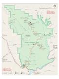
1 00110 Miles10 Kilometers1 North40404014314341628282832327373731974 7419237423191291294414414414412763213214 11441441321441321321411321321129411129 Mountains -To-SeaTrailBentonMacKayeTrailB entonMacKayeTrail Great Smoky Mountains NATIONAL PARK333231213053686970646567747598767781 8688858490919395921214151171623568996978 2636260595856545228262718192035394034444 849410042 AppalachianTrailAppalachianTrailAppalach ianTrailAppalachian Trail00877873726636382950242310913113615 55771834737 DavenportGapLaurel GapCosbyKnobTricorner KnobPecks CornerMount Le ConteCampfires ProhibitedIcewaterSpringKephartMount CollinsDouble SpringGapSilers BaldDerrickKnobRockyTopSpence FieldRussell FieldMollies Ridge00 ForneyCreekPigeonRiverWATERVILLELAKEBigC reekCataloocheeCreekJonathanCreekTuckase geeRiverSocoCreekIndianCreekFallsRamseyC ascadesGrottoFallsLaurel FallsAbramsFallsThe SinksRainbowFallsHen Wallow FallsRavenForkOconalufteeRiverRavenForkB radleyForkCosbyCreekLittlePigeonRiverMid dleProngLittlePigeonRiverWestProngLittle PigeonRiverWProngLittlePigeonRiverNoland CreekTuckasegeeRverLittleTennesseeRiverD eepCreekCoveCreekLittleRiverMiddleProngL ittleRiverHazelCreekFONTANALAKEN antahalaRiverSANTEETLAH
2 LAKEC heoahRiverLAKECHEOAHE agleCreekCALDERWOODLAKECHILHOWEELAKETENN ESSEERIVERL ittleRiverLittleRiverAbramsCreekAbramsCr eekiTENNESSEENORTH CAROLINATENNESSEENORTH CAROLINATENNESSEENORTH GroveLoop KnobAlbright GroveMount TrailGoshenProngTrailMiryRidgeTrailLumbe rRidgeTrailMeigsMountainTrailJakesCreekT railPantherCreekTrLynnCampProngTrWestPro ngTrBlanketMountainCold SpringKnobBuckeye GapJakesGapSweatHeiferCrTrailRoadProngTr ailNewfound e GreenbrierSchoolRoundtopTrailLaurelFalls TrailLittleRiverRoadChestnutTopTrailMeig sCreekTrCurryMtnTrailScottMtnTrLittl eGreenbrierTrailLittl eBrierGap Tr MetcalfBottoms TrTurkeypenRidgeTrSchoolhouse Gap trail RichMtnTrIndianGraveGapTrCrookedArmRidge (closedinwinter)RichMountainRdCadesCoveL oopRoadRich MtnLoop TrRICHMTNCADES GapGregoryBaldParsonBaldDoe TrGoldmineLoopTrailTunnelBypassTrailHigh RocksCold DomeBypass TrailClingmansDomeRoad(closedinwinter) towerAuto-access horse campHiker only campsite Shelter (Hiker only)Shelter (Horse and hiker)Horse and hiker campsit e Boat-in only campsite Ranger stationDeveloped campgroundHiking only (top)
3 Horse and hikingUnpaved roadHiking trailHorse and hiking trailTrail distances are shown in miles be-tween intersectionsMountains-To-SeaTrailBenton MacKayeTrailRoads in park are closedto commercial 2021 GSMAD ellwoodMaggie ValleyWAYNESVILLESoco GapTo AshevilleTo AshevillePlott BalsamWaterrock KnobBlueRidgeParkwayOLDBALDRIDGEPLOTTBAL SAMSP olls GapBlack Camp GapCATALOOCHEEDIVIDE(closedinwinter)NANT AHALA NATIONAL FORESTTo AtlantaWesserStecoah GapCheoah BaldNANTAHALAMOUNTAINSROBBINSVILLESNOWBI RDMOUNTAINSFONTANAVILLAGEYELLOWCREEKMOUN TAINSJOYCE KILMER - SLICKROCKWILDERNESS AREATheCherohalaScenicSkywayCHEROKEENATI ONAL FORESTF ontanaMarinaFontanaDamBRYSON CITYLakeViewDriveDeep CreekJuney WhankFalls TrailDeep Creek Horse TrailStone PileGap BOUNDARY(Eastern Band of Cherokee Indians land)
4 CHEROKEEO conalufteeClingmans Dome Visitor CenterVisitor Center Oconaluftee River trail HighlandsScience Learning CenterBalsam MountainBlueRidgeParkwayHemphillBaldTrRo ughForkTrailCataloocheeDivideTrailBooger manTrailCaldwellForkTrailHeintoogaRidgeR oadFlatCreekTrBigFkRidgeTrMcKeeBrTrSpruc e MountainTrailSpruce MountainDouble GapPurchase Gap(closedinwinter) OakGapBALSAMMOUNTAINN ewtonBaldHUGHESRIDGERICHLANDMOUNTAINTHOM ASRIDGEP almerCreekTrailChasteenCreekTrSmokemontT ow StringRound CoveVisitor CenterChilhoweeFoothillsParkwayHappyVall eyRoadCHILHOWEEMOUNTAINA brams CreekGold MineTrailLook RockTo ChattanoogaFoothillsParkwayTownsendWalla ndTUCKALEECHEECOVEE lkmontHuskey GapFightingCreekGapGreat Smoky MountainsInstitute at TremontWEARCOVES ugarlandsVisitor CenterSwain CountyVisitor CenterPark HeadquartersGATLINBURGB alsamPoint(closedinwinter)
5 CherokeeOrchardRdone-wayLaurel TopAlum SequoyahMount GuyotBalsamHigh Sterling GapPretty Hollow GapMountSterlingCove Creek GapLow KnoxvilleMcGhee-TysonAirportTo KnoxvilleCHILHOWEEMOUNTAINSEVIERVILLEPIG EON FORGEG atlinburg Welcome CenterNational Park Information CenterCOVEMOUNTAING atlinburg Bypass RoadPittmanCenterWEBBMOUNTAINTo NewportExit443 CosbyCosbyTo NewportCamel GapFoothillsParkwayMtCammererCHEROKEE NATIONAL FORESTExit 451 WatervilleBig ParkwayWear ValleyNearly all park trails cross small streams making very wet crossings during flooding. The following trails that cross streams with no bridges can be difficult and dangerous at flood stage.
6 (Asterisks ** indicate the most difficult and potentially dangerous.) This list is not Cane trail near campsite #3 Beech Gap trail on Straight Fork RoadCold Spring Gap trail at Hazel Creek Eagle Creek trail ** 15 crossingsFork Ridge Trailcrossing of Deep Creek at junction with Deep Creek TrailForney Creek trail ** seven crossingsGunter Fork trail ** five crossingsHannah Mountain trail ** just before Abrams Falls TrailJonas Creek trail near Forney CreekLittle River trail near campsite #30 Long Hungry Ridge trail both sides of campsite #92 Lost Cove trail near Lakeshore trail junctionMeigs Creek trail 18 crossingsNoland Creek trail ** both sides of campsite #62 Panther Creek trail at
7 Middle Prong trail junctionPole Road Creek trail near Deep Creek TrailRabbit Creek trail at the Abrams Falls TrailheadRoundtop trail ** crossing of Little River at Little River Road Trillium Gap trail at Grotto Falls (icy in winter)Upper Hazel Creek trail hiker-only portionWet Bottom Trailfollow signs for Elijah Oliver trail as alternate routeStream CrossingsMAP LEGENDF acility Closures123456789101112123456789101112 ABCDEFGHIABCDEFGH12345678910111212345678 9101112 Great Smoky MountainsTrail MapNational Park Department of the InteriorGreat Smoky MountainsNational ParkNorth Carolina/Tennessee5146 Snake Den Ridge Gabes Mountain TrLower Mount Cammerer TrLow Loop TrBradley ForkTowstring TrNewton Bald TrThis trail map is not intended to show legal boundary of the national areas of the park, including roads.
8 Frontcountry campgrounds, trails, and backcountry campsites/shelters are subject to closure asenvironmental conditions or operational capabilities change. Pleasecheck the park s website at for the latest closure information.(temporarily closed to motor vehicles)Heintooga/Round Bottom (closed in winter)450036802510$ Smoky Mountains National Park occupiesthe traditional lands of the Cherokee ( , Tsalagi) people, now the Eastern Band of Cherokee Indians, the Cherokee Nation, and the United Keetoowah Band of the Your SafetyDo not leave valuables in sight inside your car. Do not leave a note on your car indicating how long you will be hiking.
9 Protect your valuables by taking them with you or hiding them in your car. Leave No TraceYour personal commitment to ethical backcountry use is the most important factor in maintaining the park s wilder-ness character. Take pride in leaving no trace of your presence here. Abide by all backcountry useregulations. They are designed for resource protection. Use a stove and candle lantern to minimize the tram-pling and destruction of vegetation that result from collecting firewood. Never cook or burn food in a campfire. Food residues and odors remain and attract wildlife that will become a problem for future campers. Keep your group small to preserve a sense of solitude.
10 Camp where your campsite already shows impacts. Don't establish new tent sites. Pack out all leftover foodand trash. Avoid cutting across switch-backs to prevent destructive trail You Get LostStay calm, do not leavethe trail , and do not travelat night. Prevent getting lost by keeping your group together, staying on the trail , and using a map. Let someone know your sched-ule and travel plans, so they can notify park authoritiesif you are UseImproper human waste disposal creates one of the most disgusting conditions in the backcountry. Regula-tions require that human feces be deposited in a six-inch-deep hole and covered with soil.