Transcription of Harbour Circle Walk in Four Days A Harbour Circle Walk ...
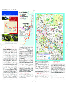
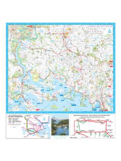
1 A four Day WalkSydney Harbour is one of the great harbours of the world. This Circle Walkbetween the Harbour and Gladesville Bridges (marked in red on the map) takesfour days and totals 59km. It can be walked continuously using overnightaccommodation, from a base such as the City or Darling Harbour using publictransport each day, or over any period of 1 Circular Quay (H8) to Greenwich Wharf (E6) 14km 5hrsDay 2 Greenwich Wharf (E6) to Woolwich Wharf (D/E5) 5hrs 30minsDay 3 Huntleys Point Wharf (A6) to Balmain East Wharf (F7) 5hrsDay 4 Balmain East Wharf (F7) to Circular Quay (H8) 15km 5hrsVisit to download leaflets for each day of the four dayversion of the walk .
2 Each leaflet has a detailed map (1:10k) and historical andgeneral interest is a magnificent walk focusing on the Harbour itself the expanse of water, thebridges, islands, urban bushland and city skyline. The route winds along parts of theforeshore, into bays and on to headlands, through bush, along historic streets andover grand One or Two Day WalkA shorter Circle of 27km between the bridges can be walked in one or twodays but bypasses many beautiful headlands. Two leaflets for this route are 1 Milsons Point (A6) to Hunters Hill (B5) 13km 5hrsDay 2 Hunters Hill (B5) to Milsons Point (H6) 14km 5hrsShorter Loop Walks As most walkers want to walk for one to four hours and savour the experience,there are 35 identified individual loop walks based on public transport.
3 Being circles,they can be commenced at any point. Each includes part of the main walk (shownin red) with additional sections (shown in green) to create loop walks. Each has itsown walk downloadable leaflet. A list of all leaflets, with walking times and distancesis shown in the adjacent Quay to The Great North walk (GNW)While many will want to start the 250 km GNW to Newcastle by the traditionalferry to Hunters Hill, others might want to walk over the Harbour Bridge andexperience the rich natural beauty, urban spaces and historic features of the NorthShore before joining the GNW and then on to Newcastle.
4 This brochure providesthree options, each shown in broken red. There is a separate leaflet for each option,see adjacent Discovery Kit for The Great North walk ($ ) can be purchased from SydneyMap Sales (Lands Dept) in Queens Square, Tel: 9228 7720. The guidebook The GreatNorth walk 1988 is also available from libraries. Parramatta and Lane Cove River WalksThis brochure shows the first parts of the Parramatta River walk from Birchgrove(E6) and Woolwich (E5) wharves west to Parramatta. Two new brochures coveringthe balance of the route to Parramatta are being finalized (see Network diagramadjacent).
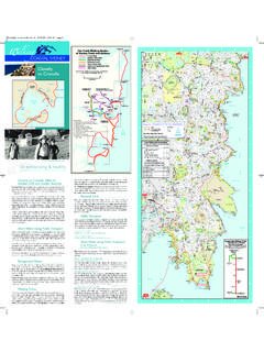
5 The Lane Cove River walk is from Woolwich wharf (E5) to Fullers Bridge(C1) on the west side and back on the east side to Greenwich wharf (E6). The Walking Coastal Sydney & The Harbour NetworkThe Trunk walking routes of the Network and the other regional brochures are shownon the diagram in the adjacent column. Sydney Harbour Federation Trust ( Harbour Trust)Best Avenue,off Suakin Drive, Mosman 2088. Tel: 8969 2100. For information on CockatooIsland (D6), Woolwich Dock & Parklands (D6), and the Trust s other sites inSydney Harbour see IncDetailed walking maps of the Lane Cove Valley and Middle Harbourcan be purchased from Step Inc and Map World - 280 Pitt Street, Sydney.
6 ($20each members $15). See City Council (E1 area) 31 Victor St, Chatswood : 9777 1000 The following brochures are available from the Customer ServiceCentre, Library or downloadable from : RoundWilloughby walk , Walking in Willoughby, Artarmon to Middle Harbour , BlueGum Reserve, Explosives Reserve, Flat Rock Gully, Ferndale Reserve, GriffinFederation Trail, The Harold Reid Foreshore Track, Mowbray Park, North ArmReserve, Railway to River walk and the Sailors Bay Walking Track. Books on Walking SydneyThere are many books on walking Sydney that are relevant to this Circle Walkavailable from libraries, bookshops and tourist offices.
7 A Harbour Circle walk isfeatured in Australian Geographic Jan-March 2006 Event 7 Bridges walk This annual event was first held in October 2006. See Pedestrian Council ofAustralia broadly follows the route of the twoday version of the Harbour Circle . To cater for the thousands of participants, insome areas this event takes a parallel route through less fragile solid red route on this brochure are being marked with the followinginternationally recognised yellow bar s exhilarating & healthySydneyHarbourBridgeversion 15-32-2 (2010)HUNTERSHUNTERSHILLHILLNORTHNORTHSY DNEYSYDNEYSYDNEYSYDNEYLANELANECOVECOVEDR UMMOYNEDRUMMOYNEBALMAINBALMAINWILLOUGHBY WILLOUGHBY2341 SYDNEY HARBOURW alking TimesTimes and distances are shown for all walks.
8 Remember that the times markedare walking times only and are based on a walking speed of between to 3kilometres per hour, depending on the terrain. Add your own time for breaks,lunch or just CareThe walk requires average fitness. Take care as it includes a variety of terrain andpathway conditions. Use sunscreen, carry water and wear a hat and goodwalking TransportPublic transport is readily available at regular intervals along the way (see map).This allows considerable flexibility in entering and exiting the route. Note: not allservices operate every day, and routes and timetables Bus, train and ferry (routes shown in blue) timetables.
9 Infoline Tel: 131-500, Ferries (routes shown in green mainly linking City and Lane Cove River wharves) Tel: 9264 7377, on Metro Light Rail (MLR) Tel: 9285 5600, , Drink & ToiletsCarry food and some water at all times. Food and drink are usually availablealong the route, but shops are not always open. Toilets along the way are marked AccommodationAll overnight stops are at excellent transport hubs. The four Day walk can bedone from one accommodation point such as Central CBD, The Rocks or NorthSydney. Another option is to stay overnight on or near the route, and some B&Bsare marked on the information on bed and breakfast, historic hotels (some are shown on themap) and other accommodation, see Tourism NSW ,NRMA Tel: 13 1122 Sydney Visitor InformationBrochures and Individual LeafletsThis and other brochures are downloadable pdfs ( ) but the scale will be small if printed on A4pages.
10 Enlarging the pdf on screen and using the select tool to copy and thenprint the map in sections will assist. All day and loop walk leaflets download easilyonto A4. Some of the following bodies have free copies of some Bay - City of (B7 area) 1a Marlborough Street, Drummoyne : 9911 6555. Downloads on Canada Bay Council s attractions and sites includingMp3s and foreshore walk maps are available on View the Area Map .Hunters Hill Council (B5 area) 22 Alexandra Street, Hunters Hill : 9879 9400. Walks in Hunters Hill: Hunters Hill Woolwich Walks and HuntersHill Gladesville Walks are available from the Customer Service Centre, and aredownloadable from click walking maps.