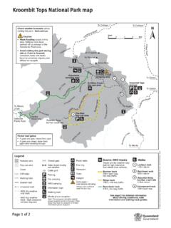
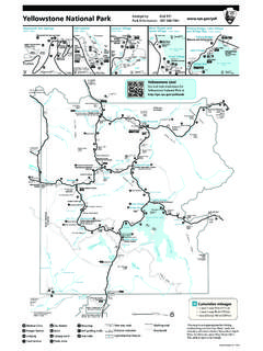
Transcription of K’gari (Fraser Island) Recreation Area map
1 Marloo zone 8 Caution: Deep wash-outs at mouth of Eli Creek. Beach passable 2 hours either side of low Allom Lake WabbyEurong QPWS officeOne Tree Rocks zone 2 Wongai zone 1 Kirrar SandblowBoorangoora (Lake McKenzie)Hervey BayWinnam zone 3 Poyungan zone 3 Gabala zone 2 Cornwells zone 2 Yidney RocksPoyungan Roc ksRiver Heads Happy ValleyEli zone 4 Guluri zone 4fencedhikersUr ang C reekLakeGar awongeraRed CanyonDundubaraCathedrals on fraser (private)K gari (private)Maheno Wreck Eli Creek*Moon PointWyuna zone 7 Guruman zone 6 Yurru zone 6 Eugarie zone 6 Wahba zone 5 Maheno zone 5 The PinnaclesWoralie CreekCoongul CreekBowarrady CreekAwinya CreekBowal CreekWungulSandblowLake BowarradyBoomerangLakesLake CoombooGreat SandyMarine ParkfencedfencedfencedKnifebladeSandblow fencedBurad zone 7 Corroboree Beach* Sandy CapeOcean LakeWaddy PointMiddle RocksWathumba *Orchid BeachPlatypus BayRooney PointCarree zone 9 Diray zone 9 Duling zone 8 Ocean Lake zone 8 Ngkala RocksTeebing(Wathumba spit)Orange CreekTowoi CreekSouthPacificOceanfencedfenced 30km/h inland roads 40km/h beach pedestrian areas 80km/h Eastern beach 50km/h Hook Point inland roadSurvive your drive All road rules apply.
2 Conditions change. Speed limits: Camp at least 50 metres from the water s edge. Never clean fish or discard fish or food scraps near the water s edge, campsites or boat ramps. Take care when launching or retrieving your croc wise Estuarine crocodile sightings have been reported on the west coast of fraser Island and the Great Sandy BeachGarrys AnchorageHook P oint inland road18km beach access ramp11km beach access rampDilli Village (private)Govi zone 1 LakeBoomanjinEurongUngowaCentral StationWanggoolba CreekLakeBirrabeenLakeBenaroonCaution: Beac h is only passable at low PointInskip PointfencedhikersfencedThe K'gari ( fraser Island) Section of Great Sandy national Park is surrounded by Great Sandy Marine Park. Visit for further detailed fraser Island Great!
3 Walk topographic map can be purchased online, over the counter or by phone at !WalkGreat Sandy Marine ParkNo vehicle zone: Beach driving is not permitted from Coolooloi Creek to Moon Point. Kingfisher BayYidney ScrubCoolooloi CreekMoon PointGreat Sandy StraitNo vehicle zone: Beach driving is not permitted from Towoi Creek to Sandy Cape Lighthouse gateCaution: Soft boggy sand on the Tukkee wurroo (Indian Head) bypass track. Caution: Moon Point to Towoi Creek soft boggy sand and deep creek crossings; potentially stingers are present in the ocean, especially in the summer months. Swimming is not wurroo (Indian Head)WARNINGLook and listen for aircraft landing and taking off along the eastern gari ( fraser Island) Recreation Area mapGreat Sandy national Park State of Queensland. Queensland Parks and Wildlife Service.
4 MA250 January 20205101520kmScale0 LegendRecreation areaOther lands4WD trackWalking trackNo vehicle zone hazardous beachGreat!Walk*Central Lakes scenic driveSouthern Lakes scenic driveLake Garawongera scenic driveNorthern Forests scenic driveBeach camping areaDistance (kilometres)QWPS Information CentreRanger station4WD tent camping Boat access camping Walk-in camping4WD camper trailerPrivate accomodationShop, gas, iceFuelToiletsWaste transfer stationPicnic table Sheltered picnic tableTelephoneLookoutWalking trackBarge landingPolice station AmbulanceWreckSandy Cape lighthouseDishwashing areaPortable toilet waste disposal facilityWater treat before drinkingNo camper trailers Do not swim in the ocean NEVER feed wongari (dingoes). Always stay within arm s reach of children, even small teenagers.
5 Walk in groups and carry a stick. Do not run. Running or jogging can trigger a negative wongari interaction. Camp in fenced areas when possible. Lock up food stores and iceboxes (even on a boat). Never store food or food containers in tents. Secure all rubbish, fish and wongari safety advice provided with permits and on signs throughout the island. Be Dingo-Safe!