Example: bachelor of science
Kroombit Tops National Park map - Parks and forests
Title: Kroombit Tops National Park map Author: Queensland Government; Queensland Parks and Wildlife Service Subject: Map of Kroombit Tops National Park indicating access, facilities, features, tracks and camping.
Tags:
Information
Domain:
Source:
Link to this page:
Documents from same domain
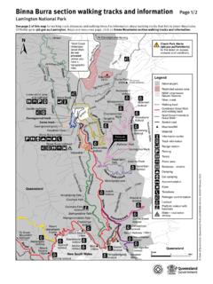
Lamington Binna Burra Map - Parks and forests
parks.des.qld.gov.auLamington National Park map: Binna Burra walking tracks and information Author: Queensland Department of Environment and Science Subject: Map of the Binna Burra section of Lamington National Park showing access, facilities and recreational opportunities and safety messages. Legend provided. Keywords

Moreton Island National Park and Recreation Area map
parks.des.qld.gov.auTitle: Moreton Island National Park and Recreation Area map Author: Queensland Department of Environment and Science Subject: Moreton Island National Park and Recreation Area map, indicating access, facilities, features, tracks and vehicle access and speed zones.
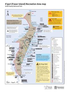
K’gari (Fraser Island) Recreation Area map
parks.des.qld.gov.auTitle: K'gari (Fraser Island) Recreation Area map Great Sandy National Park Author: Queensland Department of Environment and Science Subject: Map of K'gari (Fraser Island), Great Sandy National Park indicating locality, access, walking tracks and facilities.

Noosa National Park walking tracks map Headland Section
parks.des.qld.gov.auGranite Bay Alexandria Bay Lion Rock Noosa Heads Surf Life Saving Club Sunshine Beach Surf Life Saving Club Boiling Day-use area Pot Dolphin Point Hell’s Gates Laguna Lookout Sunshine Beach e Sunshine D a v i d L o w W a y Surf St Emergency radio Sunshine Beach edge Rd ong e Bicentennial Dr 3 1 2 4 4 5 4 2 Park Rd St Seaview Tce
Cape York Peninsula - Department of Environment and ...
parks.des.qld.gov.auYork Peninsula. From May to July, maximum temperatures are around 30°C. As the season progresses, the days become hotter and more humid. The peninsula is busiest between June and September, during the ‘cooler’ weather. School holiday periods (July and September) are best avoided if you seek solitude. Parks on the peninsula are closed during
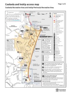
Cooloola and Inskip access map - Parks and forests
parks.des.qld.gov.au(Northern beach access road) See northern access map page 2 Bullock Inskip Point Inskip Peninsula ... including in vehicles or trailers traversing beaches and inland tracks. High clearance 4WD vehicles with ... Horses are permitted on the council horse trail and on the beach indicated on the map. (no public facilities) Noosa River estuary

Teewah Beach camping zones map Cooloola Recreation Area
parks.des.qld.gov.auBring your own portable toilet. Portable toilets are mandatory for all campers in the Teewah Beach camping zones. All Qld road rules apply on Teewah Beach. Legend Recreation Area Water 4WD camping zone No camping area 4WD camping only 4WD camper trailer 4WD caravan Toilets Bring your own portable toilet Portable toilet waste disposal Shower ...

Cooloola Conditions Report
parks.des.qld.gov.auwater for the first time. Never drive or park on the dunes and only use established access tracks to camp sites. Do not interfere with turtle nests, eggs or hatchlings. Stay well clear of turtles leaving the water or crossing the beach, and avoid driving on the beach and using bright lights between 6pm and 6am during breeding season.

K'gari (Fraser Island) conditions report
parks.des.qld.gov.auK’gari (Fraser Island) conditions report Everything is protected – plants, animals, natural and cultural features www.des.qld.gov.au General alerts Reviewed 06 January 2022 The Department of Environment and Science (DES) continues to monitor and receive guidance from the Government in relation to COVID-19 health and safety

Moreton Bay Marine Park
parks.des.qld.gov.auEntry and use guide Gene r a l se zone Ha b i t a t protection zone C o n se r v ation park zone M arine n atio nal park zone Boating Yes Line fishing Yes Yes Yesa Nob Crabbing Yes Yes Yesc Nob Trolling Yes Yes Yes No Bait gathering Yes Yes Yes Nob ait netting Yes No Netting (other than bait netting) Yes Yes Nob Nob Limited spearfishing Yes ...
Related documents
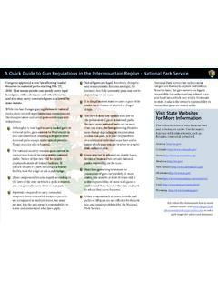
A Quick Guide to Gun Regulations in the Intermountain ...
www.nps.govnational parks, guns cannot be fired except in rare circumstances. Hunting is illegal in most national parks except under special permits. Target practice also is banned. • For national security reasons, guns cannot be carried into federal facilities within national parks. Notice of this rule will be clearly displayed outside all federal ...
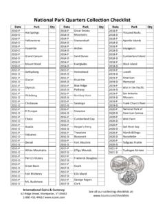
National Park Quarters Collection Checklist
iccoin.comAbout National Park Quarters In 2010, the United States Mint began issuing 56 quarter-dollar coins featuring designs depicting national parks and other national sites as part of the United States Mint America the Beautiful Quarters® Program. Each coin in the series features a common obverse with the 1932 portrait of
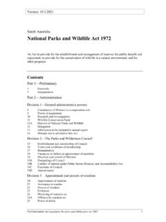
National Parks and Wildlife Act 1972 - legislation.sa.gov.au
www.legislation.sa.gov.auNational Parks and Wildlife Act 1972—3.10.2019 Part 1—Preliminary 2 Published under the Legislation Revision and Publication Act 2002 Council means the Parks and Wilderness Council established under . section 15; Crown land. means— (a) unalienated land of the Crown; or
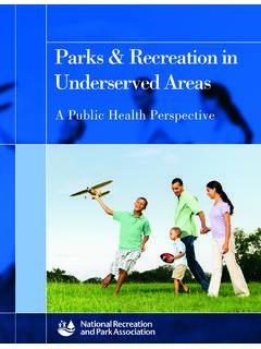
Parks & Recreation in Underserved Areas
www.nrpa.orgaccess to public parks, public pools and green space, national-based studies show evidence that access to the same amenities is much lower in neighborhoods largely occupied by African Americans8,18. The national guideline on sufficient distribution of parkland ranges from 6 acres to 19 acres per 1,000 of the

FEDERAL RECREATION AREAS WHERE INTERAGENCY …
store.usgs.govKEY: NWR = National Wildlife Refuge; BLM = Bureau of Land Management; NF = National Forest; NRA = National Recreation Area; NHS = National Historic Site; USACE= Army Corps of Engineers IMPORTANT! This list is not comprehensive and may include errors; some Federal recreation sites are only open part-time or may change what passes are issued or ...
The National Park Quarter Collector Checklist
www.littletoncoin.comNational Historical Park VT q P q D q S q S q S-Slv Tallgrass Prairie National Preserve KS q P q D q S q S q S-Slv 2021 Tuskegee Airmen National qHistoric Site AL P q D S S-Slv State or Territory State or LC-3843 8/15 America’s Favorite Coin Source • TRUSTED SINCE 1945 ©2010-2015 LCC, Inc. ...
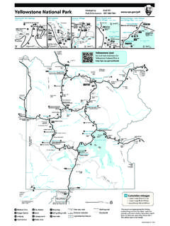
Yellowstone National Park Emergency Dial 911 Park ...
www.nps.govNational Park Mountain 7500ft/2286m 7484ft 2281m l a c k t ai l P a t e a D r. Lake Butte 8348ft 2544m Mount Norris 9936ft 3028m Electric Peak 10967ft 3343m Barronette Peak 10404ft Chittenden Road Hellroaring Mountain 8363ft 2549m Silver Gate Cooke City West Yellowstone Gardiner Jardine John D. Rockefeller, Jr. Memorial Parkway Grand Teton ...
K’gari (Fraser Island) Recreation Area map
parks.des.qld.gov.auTitle: K'gari (Fraser Island) Recreation Area map Great Sandy National Park Author: Queensland Department of Environment and Science Subject: Map of K'gari (Fraser Island), Great Sandy National Park indicating locality, access, walking tracks and facilities.