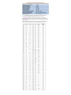
Transcription of Key to Aerodrome Forecast (TAF) and Aviation Routine ...
1 Key to Aerodrome Forecast (TAF) and Aviation Routine weather report (METAR) (Front) TAF KPIT 091730Z 0918/1024 15005KT 5SM HZ FEW020 WS010/31022KT FM091930 30015G25KT 3SM SHRA OVC015 TEMPO 0920/0922 1/2SM +TSRA OVC008CB FM100100 27008KT 5SM SHRA BKN020 OVC040 PROB30 1004/1007 1SM -RA BR FM101015 18005KT 6SM -SHRA OVC020 BECMG 1013/1015 P6SM NSW SKC NOTE: Users are cautioned to confirm DATE and TIME of the TAF. For example FM100000 is 0000Z on the 10th. Do not confuse with 1000Z! METAR KPIT 091955Z COR 22015G25KT 3/4SM R28L/2600FT TSRA OVC010CB 18/16 A2992 RMK SLP045 T01820159 Forecast Explanation report TAF Message type: TAF- Routine or TAF AMD-amended Forecast , METAR-hourly, SPECI-special or TESTM-non-commissioned ASOS report METAR KPIT ICAO location indicator KPIT 091730Z Issuance time: ALL times in UTC Z , 2-digit date, 4-digit time 091955Z 0918/1024 Valid period, either 24 hours or 30 hours.
2 The first two digits of EACH four digit number indicate the date of the valid period, the final two digits indicate the time (valid from 18Z on the 9th to 24Z on the 10th). In METAR: CORrected of; or AUTO mated ob for automated report with no human intervention; omitted when observer logs on. COR 15005KT Wind: 3 digit true-north direction , nearest 10 degrees (or VaRiaBle); next 2-3 digits for speed and unit, KT (KMH or MPS); as needed, Gust and maximum speed; 00000KT for calm; for METAR, if direction varies 60 degrees or more, Variability appended, , 180V260 22015G25KT 5SM Prevailing visibility; in , Statute Miles & fractions; above 6 miles in TAF Plus6SM. (Or, 4-digit minimum visibility in meters and as required, lowest value with direction) 3/4SM Runway Visual Range: R; 2-digit runway designator Left, Center, or Right as needed; / , Minus or Plus in , 4-digit value, FeeT in , (usually meters elsewhere); 4-digit value Variability 4-digit value (and tendency Down, Up or No change) R28L/2600FT HZ Significant present, Forecast and recent weather : see table (on back) TSRA FEW020 Cloud amount, height and type: SKy Clear 0/8, FEW >0/8-2/8, SCaTtered 3/8-4/8, BroKeN 5/8-7/8, OVerCast 8/8; 3-digit height in hundreds of ft; Towering CUmulus or CumulonimBus in METAR; in TAF, only CB.
3 Vertical Visibility for obscured sky and height VV004 . More than 1 layer may be reported or Forecast . In automated METAR reports only, CLeaR for clear below 12,000 feet OVC 010CB Temperature: degrees Celsius; first 2 digits, temperature / last 2 digits, dew-point temperature; Minus for below zero, , M06 18/16 Altimeter setting: indicator and 4 digits; in , A-inches and hundredths; (Q-hectoPascals, , Q1013) A2992 WS010/31022KT In TAF, non-convective low-level ( 2,000 ft) Wind Shear; 3-digit height (hundreds of ft); / ; 3-digit wind direction and 2-3 digit wind speed above the indicated height, and unit, KT Key to Aerodrome Forecast (TAF) and Aviation Routine weather report (METAR) (Back) In METAR, ReMarK indicator & remarks. For example: Sea- Level Pressure in hectoPascals & tenths, as shown: hPa; Temp/dew-point in tenths _C, as shown: temp.
4 , dew-point RMK SLP045 T01820159 FM091930 FroM: changes are expected at: 2-digit date, 2-digit hour, and 2-digit minute beginning time: indicates significant change. Each FM starts on a new line, indented 5 spaces TEMPO 0920/0922 TEMPO rary: changes expected for <1 hour and in total, < half of the period between the 2-digit date and 2-digit hour beginning, and 2-digit date and 2-digit hour ending time PROB30 1004/1007 PROB ability and 2-digit percent (30 or 40): probable condition in the period between the 2-digit date & 2-digit hour beginning time, and the 2-digit date and 2-digit hour ending time BECMG 1013/1015 BECoMinG: change expected in the period between the 2-digit date and 2-digit hour beginning time, and the 2-digit date and 2-digit hour ending time Table of Significant Present, Forecast and Recent weather - Grouped in categories and used in the order listed below; or as needed in TAF, No Significant weather .
5 Qualifiers Intensity or Proximity - = Light No sign = Moderate + = Heavy VC = Vicinity, but not at Aerodrome . In the US METAR, 5 to 10 SM from the point of observation. In the US TAF, 5 to 10 SM from the center of the runway complex. Elsewhere, within 8000m. Descriptor BC Patches BL Blowing DR Drifting FZ Freezing MI Shallow PR Partial SH Showers TS Thunderstorm weather Phenomena Precipitation DZ Drizzle GR Hail GS Small Hail/Snow Pellets IC Ice Crystals PL Ice Pellets RA Rain SG Snow Grains SN Snow UP Unknown Precipitation in automated observations Obscuration BR Mist ( 5/8SM) DU Widespread Dust FG Fog (<5/8SM)
6 FU Smoke HZ Haze PY Spray SA Sand VA Volcanic Ash Other DS Dust Storm FC Funnel Cloud +FC Tornado or Waterspout PO Well developed dust or sand whirls SQ Squall SS Sandstorm - Explanations in parentheses () indicate different worldwide practices. - Ceiling is not specified; defined as the lowest broken or overcast layer, or the vertical visibility. - NWS TAFs exclude BECMG groups and temperature forecasts, NWS TAFS do not use PROB in the first 9 hours of a TAF; NWS METARs exclude trend forecasts. US Military TAFs include Turbulence and Icing groups.