Example: marketing

Lakeshore GPS Data - National Park Service

Lakeshore GPS DataPictured Rocks National LakeshoreNational park Department of the Interior Wild Beauty on the Lake Superior Shore More visitors are using GPS (Global Positioning System) units while hiking and kayaking. Below is a listing of the Lakeshore backcountry GPS data for Pictured Rocks National Lakeshore . Please remember that a backcountry permit (fee) is required for overnight camping in the backcountry. Geocaching is prohibited within the Lakeshore and all units of the National park mapping and aerial imagery sites: State of Michigan maps and Coordinates for Lakeshore Backcountry CampgroundsHorizontal Datum: Geographic NAD83 UTM Zone 16 Latitude Longitude Easting NorthingBEAVER LAKE 46 33 86 20 LAKE GROUP 46 33 86 20 GROUP 46 29 86 33 46 28 86 34 PATCH 46 29 86 31 GROUP 46 31 86 29 46 31 86 29 46 34 86 22

Lakeshore GPS Data Pictured Rocks National Lakeshore National Park Service U.S. Department of the Interior “Wild Beauty on the Lake Superior Shore” More visitors are using GPS (Global Positioning System) units while hiking and kayaking.

Tags:

  Services, Data, Park, National, National park service, Lakeshore, Lakeshore gps data, National lakeshore national park service

Information

Domain:

Source:

Link to this page:

Please notify us if you found a problem with this document:

Other abuse

Transcription of Lakeshore GPS Data - National Park Service

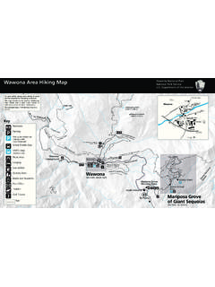
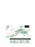
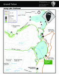
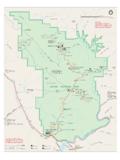
1 Lakeshore GPS DataPictured Rocks National LakeshoreNational park Department of the Interior Wild Beauty on the Lake Superior Shore More visitors are using GPS (Global Positioning System) units while hiking and kayaking. Below is a listing of the Lakeshore backcountry GPS data for Pictured Rocks National Lakeshore . Please remember that a backcountry permit (fee) is required for overnight camping in the backcountry. Geocaching is prohibited within the Lakeshore and all units of the National park mapping and aerial imagery sites: State of Michigan maps and Coordinates for Lakeshore Backcountry CampgroundsHorizontal Datum.

2 Geographic NAD83 UTM Zone 16 Latitude Longitude Easting NorthingBEAVER LAKE 46 33 86 20 LAKE GROUP 46 33 86 20 GROUP 46 29 86 33 46 28 86 34 PATCH 46 29 86 31 GROUP 46 31 86 29 46 31 86 29 46 34 86 22 GROUP 46 33 86 23 46 38 86 12 46 37 86 15 GROUP 46 37 86 15 BLUFF 46 35 86 19 CREEK 46 34 86 21 HOMESTEAD 46 38 86 05 HOMESTEAD GRP 46 38 86 05 GROUP 46 35 86 18 46 35 86 18 46 32 86 26 SABLE GROUP 46 40 86 08 SABLE POINT 46 40 86 08 : denotes kayak accessible sit


Related search queries