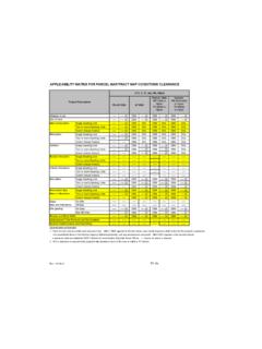
Transcription of LEGEND - ZIMAS
1 LEGEND . GENERALIZED ZONING. OS, GW. A, RA. RE, RS, R1, RU, RZ, RW1. R2, RD, RMP, RW2, R3, RAS, R4, R5. CR, C1, , C2, C4, C5, CW, ADP, LASED, CEC, USC, PVSP, PPSP. CM, MR, WC, CCS, UV, UI, UC, M1, M2, LAX, M3, SL. P, PB. PF. GENERAL PLAN LAND USE. LAND USE. RESIDENTIAL industrial . Minimum Residential Commercial Manufacturing Very Low / Very Low I Residential Limited Manufacturing Very Low II Residential Light Manufacturing Low / Low I Residential Heavy Manufacturing Low II Residential Hybrid industrial Low Medium / Low Medium I Residential PARKING. Low Medium II Residential Medium Residential PORT OF LOS ANGELES. High Medium Residential General / Bulk Cargo - Non Hazardous ( industrial / Commercial). High Density Residential General / Bulk Cargo - Hazard Very High Medium Residential Commercial Fishing COMMERCIAL Recreation and Commercial Limited Commercial Intermodal Container Transfer Facility Site Limited Commercial - Mixed Medium Residential LOS ANGELES INTERNATIONAL AIRPORT.
2 Highway Oriented Commercial Airport Landside Highway Oriented and Limited Commercial Airport Airside Highway Oriented Commercial - Mixed Medium Residential Airport Northside OPEN SPACE / PUBLIC FACILITIES. Community Commercial Open Space Community Commercial - Mixed High Residential Public / Open Space Regional Center Commercial Public / Quasi-Public Open Space Other Public Open Space FRAMEWORK Public Facilities COMMERCIAL industrial . Neighborhood Commercial Limited industrial General Commercial Light industrial Community Commercial Regional Mixed Commercial CIRCULATION. STREET. [[[[[[[[[[[ Arterial Mountain Road [[[[[[[[[[[ Major Scenic Highway [[[[[[[[[[[ Collector Scenic Street [[[[[[[[[[[[[[[[. Collector Street [[[[[[[[[[[ Major Scenic Highway II. Collector Street (Hillside) Mountain Collector Street Park Road Collector Street (Proposed) Parkway Country Road Principal Major Highway Divided Major Highway II Private Street [[[[[[[[[[[ Divided Secondary Scenic Highway [[[[[[[[[[[ Scenic Divided Major Highway II.]]]]]]]]]]]]]]]]]]]]]]]]]]]]]]]]]]]]] ]]]]]]]]]]]]]]]]]]]]]]]]]]]]]]]]]]]]]]]] ]]]]]
3 [ [ [ [ [ [ [ [ [ [[ Local Scenic Road Scenic Park Local Street [[[[[[[[[[[ Scenic Parkway Secondary Highway Major Highway I. Major Highway II [[[[[[[[[[[ Secondary Scenic Highway Special Collector Street Super Major Highway FREEWAYS. Freeway Interchange Railroad [[[[[[[[[[ Scenic Freeway Highway MISC. LINES. Airport Boundary MSA Desirable Open Space Bus Line U U Major Scenic Controls Coastal Zone Boundary Multi-Purpose Trail Coastline Boundary Natural Resource Reserve ( ! ( ! ( ! ( ! (. ! Collector Scenic Street (Proposed) Park Road ) ) ) Commercial Areas Park Road (Proposed). Commercial Center Quasi-Public Community Redevelopment Project Area Rapid Transit Line Country Road Residential Planned Development DWP Power Lines Scenic Highway (Obsolete). ########## Desirable Open Space U U Secondary Scenic Controls ( (.))))]]]]]]]]]]]]]]]]]]]]]]]]]]]]]]]]]] ]]]]]]]]]
4 Detached Single Family House ( (. Secondary Scenic Highway (Proposed). 8 8 8 8 8 8 Endangered Ridgeline Site Boundary Equestrian and/or Hiking Trail ? Southern California Edison Power ! ! ! ! ! Hiking Trail Special Study Area ( ( ( (. Historical Preservation Horsekeeping Area Stagecoach Line Local Street 8 8 8 8 8 8 Wildlife Corridor POINTS OF INTEREST. SCHOOLS/PARKS WITH 500 FT. BUFFER. Existing School/Park Site Planned School/Park Site Aquatic Facilities Other Facilities OS. Opportunity School Beaches Park / Recreation Centers CT. Charter School Child Care Centers Parks ES. Elementary School Dog Parks Performing / Visual Arts Centers SP. Span School Golf Course Recreation Centers SE. Special Education School Historic Sites Senior Citizen Centers HS. High School Horticulture/Gardens MS.))))))
5 Middle School EEC. Skate Parks Early Education Center COASTAL ZONE TRANSIT ORIENTED COMMUNITIES (TOC). Coastal Zone Commission Authority Tier 1 Tier 3. Calvo Exclusion Area Tier 2 Tier 4. Not in Coastal Zone Note: TOC Tier designation and map layers are for reference purposes only. Eligible projects shall demonstrate compliance with Tier eligibility standards Dual Jurisdictional Coastal Zone prior to the issuance of any permits or approvals. As transit service changes, eligible TOC Incentive Areas will be updated. WAIVER OF DEDICATION OR IMPROVEMENT. Public Work Approval (PWA). Waiver of Dedication or Improvement (WDI). LAMC SECTION (VEHICLE DWELLING). No vehicle dwelling anytime No vehicle dwelling overnight between 9:00 PM - 6:00 AM. Must comply with all posted parking restrictions Vehicle dwelling allowed.
6 Must comply with all posted parking restrictions OTHER SYMBOLS. Lot Line Airport Hazard Zone Flood Zone Tract Line Census Tract Hazardous Waste Lot Cut Coastal Zone High Wind Zone Easement Council District Hillside Grading Zone Boundary Historic Preservation Overlay Zone Building Line Downtown Parking Lot Split Fault Zone Very High Fire Hazard Severity Zone Community Driveway Fire District No. 1 ! ( Oil Wells J Lot Ties Tract Map Parcel Map Building Outlines 2014. Building Outlines 2008.)