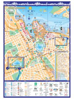
Transcription of LYNN WOODS RESERVATION A B D E F C
1 12345678 ABDEFT racy TrailWALDEN PONDBIRCH PONDW aycrossRoadRoadGreat WoodsRoadGannonMunicipalGolf CourseLYNNFIELDSAUGUSLYNN lynn SAUGUSW alnut StreetParkland AvenueLynnfield StreetGreat WOODS RoadGreat WOODS RoadEntranceBall FieldPennybrookRoadWalnut StreetWalden PondRoadCedar HillTomlin'sSwampRamsdell's SwampLong SwampEchoRockWater TowerCooke RoadCookeRoadPathUnion RockNeedham'sClearingHemlockRidgeBoulder PathDungeonRoadJacksonPathUndercliffPath Route 1 Lynnfield StreetPower LinesPower LinesDog HillWyomaSquareMeeting HouseSwampWeetamooCliffBalancedBoulderPi rateBoulderWolf Pits461321512421736123421344833222632332 1112212334567467895211116543176552331814 23454312 Bow RidgeOx Pasture RoadNell'sPondOverlookCragGreat FrogBoulderOverlook TrailTrailTrailTrailOverlookOverlookAmph itheatrePennyBridgeDungeonRockFoxRockRoa dLoopRose GardenMap Illustration By: Mark F.
2 McInerney, Preliminary Map Layout and Survey: Scott Whitcomb, Field Verification: Mike HedetniemiPennybrookPennybrookCornelMidd le Pasture WallMiddle Pasture WallN1 Stone TowerFuller HillMount MoriahElev. 220 TowerElev. 212 272 228 HillElev. 285 EntranceMount GileadBirch Pond TrailBREED'S design of this map was made possible by a Massachusetts Department of Environmental Management's Greenways and Trails Demonstration GrantLYNN WOODS RESERVATIONCLynn SpecialNeeds Camp10000100020003000400001/21 MileSCALE: 1inch = 1/4 mileW 70 58'N 42 29'W 70 59'N 42 30'W 71 00'N 42 31'W 71 01'N 42 30'WetlandPondPoints of InterestBrookParkingReservation AreaPaved RoadUnpaved RoadHiking / Walking TrailEmergency Boat RampLegendAll official trail and road intersections arenumbered using the grid system on the major intersection in lynn WOODS hasa small blue sign on a tree showing the gridblock-intersection example the intersection at Stone Towerreads "D6-1"How to use this mapOfficial Trail Markings Fire Roads = orangeNature Trails = greenOverlook Trail = redAll Other Trails =
3 BluePlease stay on official trails and roads