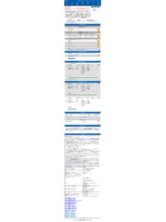
Transcription of Map Legend Cougar Mountain (map on reverse) Regional ...
1 Map Legend (map on reverse) Cougar Mountain SAFETY NOTE: Due to hazards from historical mining activities in this park Regional Wildland Park you must stay on the trails identified on this map. Access Trailheads Red Town Trailhead From I-90 Take Exit 13 and drive south on Lakemont hiking, horseback riding Boulevard SE for miles. Look for the entrance to the Red Bicycles are not Town Trailhead on the left side of the road. hiking allowed on the park trails. From I-405 Take Exit 10 and follow Coal Creek Parkway SE miles to the shopping center. Turn left at the light onto SE 72nd Trails Place and then left again at Newcastle Golf Club Road. Follow King County-maintained | other that for miles. The entrance to the Red Town Trailhead is on hiking, horseback riding the right side of the road just after the big bend. | hiking only Sky Country Trailhead From I-90 Take Exit 13 and drive south on Lakemont Facilities and features Boulevard SE for miles.
2 Turn left on SE Cougar Mountain picnic area hitching rail Way and then right on 166th Way SE. Follow 166th for .7 miles to its end. On the right is the Sky Country Trailhead parking lot. point of interest parking area This lot includes space for horse trailers. viewpoint restrooms Harvey Manning Trailhead From I-90 Take Exit 13 and drive south on Lakemont waterfall park and ride Boulevard SE for miles. Turn left onto SE Cougar Mountain Way. Follow the double yellow line. (The road will first swing Publicly owned land left and become 168th Place SE, and then right to become SE. King County: Cougar Mountain 60th Street.) Turn off 60th Street uphill onto SE Cougar Regional Wildland Park Mountain Drive. The road will change to gravel, and at the very end is the Harvey Manning Trailhead, where you will find other King County Park land restrooms, picnic tables and a playfield. other park or open space Jim Whittaker Wilderness Peak Trailhead From I-90 Take Exit 15 and drive south on SR-900 (17th Avenue NW and then Renton-Issaquah Road SE) for miles.
3 Other basemap features Look for the trailhead sign and an asphalt driveway that goes incorporated city uphill to the right. unincorporated King County This information is available in alternative formats upon request. Please call 206-477-4527. wetland or 1-800-325-6165. Washington Relay Service: 1-800-833-6388. arterial street gates For information about King County Parks, local street water tank please call 206-477-4527. elevation contour (interval = 50 ft.) Visit King County Parks on the Internet at April 2020. Trail Lengths in Miles Cougar Mountain Regional Wildland Park is the gem of King County's 30,000-acre park W6 Marshall's Hill E2 Surprise Creek Trail .. Calculated from current digital data; older system. Just minutes from Eastside cities such as Bellevue, Newcastle and Issaquah, W7 Indian E3 Bear Ridge trail signs may indicate different values. W9 De Leo Wall E4 Whittaker Wilderness Peak Tr.
4 Cougar Mountain Park provides an excellent example of our region's unique historical, N2 Military Road Trail .. W10 Bagley Seam Trail .. E5 Gombu Wilderness Cliffs Trail .. cultural and natural heritage. Located in the Issaquah Alps, Cougar Mountain Park N3 Radio Peak Trail .. C1 Clay Pit E8 No Name preserves important wildlife habitat while offering ample opportunities for recreation. N4 Coyote Creek Trail .. C2 Red Town Creek Trail .. E9 Protector Trail .. N5 Klondike Swamp Trail .. C3 Cave Hole Trail .. E10 West Tibbetts Creek Trail .. N6 Lost Beagle Trail .. C4 Coal Creek Falls Trail .. E11 Squak Mtn. Connector Trail .. N7. N8. Harvey Manning Trail .. Cougar Pass Trail .. C6 Quarry Trail .. C7 Fred's Railroad E12. E13. Red Cedars Precipice Top Trail .. A G reat Big G reen and Quiet Pl ace . N9 Tibbetts Marsh C8 East Fork Trail .. E14 Military Ridge Trail (in park) .. N10 Primrose Overlook C9 By Pass Trail.
5 E15 Big Tree Ridge Trail .. Harvey Manning N11 Little Creek Trail .. C10 Mine Shaft S1 Far Country 1925 - 20 0 6. W1 Wildside Trail .. C11 Old Man's Trail .. S2 Shy Bear Trail .. W2 Red Town C12 Nike Horse Trail .. S3 Deceiver W3 Rainbow Town Trail .. C13 Sky Country Trail .. S4 Long View Peak Trail .. Want the map on your phone? Text KING Cougar to 468311. W4 Steam Hoist Trail .. E1-W Shangri La Trail (west) .. S5 Ring Road Trail .. *Message & Data Rates May Apply W5 China Creek Trail .. E1-E Shangri La Trail (east).. S6 Licorice Fern SE 60th St 70 400. 900 0. 300. 600 500. 120 80. 0 Ne 10. 0. 20. 00. 130 11 wp Trail 85. 0. 0. 10. 00. 5. o E1. 0. ge 0. BELLEV U E. SE ugar Mo rt . Co id W. 0. 650 R. 90. 600. ee a un l 900. 950. 1400 ta The Cougar Mountain Park T. r P. i n Drive y 12 125. Fo r e s 800. SE 6 5t h ig SE. 00 0. NW. t Dr iv maintenance office is located at Big Tree25 Ridge B.
6 E SE. 13. 0. 800. ou N4 . 750. the Harvey Manning Trailhead. C. Trailhead 00. E1W . 750 ga 5 E. r M ountain Way Elevation: 89 ft Sh rail 1400 Harvey Manning 27 m E1. angri La T . L a ke m 14. 550 Trailhead 2. E 13. 750. E1. 450 450 Cinder For trail questions in Bellevue, Elevation: 1430 ft Issaquah edars Tr.. il mine 436 m Transit Harvey Manning E1. Coal Creek please call 425-452-7225. 90. Tra Pr Trail 500. 70. 50. Co 0. To ont Blv W. ec Center 0. 550 Park at Talus 14. Cou Anti-Aircraft p ipice 1400. 3. 65 gar 00. 60. Co Red C. al Peak 110. 0 M tn 1 Tibbetts Lot 60. Primrose Natural Area al 10. 0. N7. 600. E12 . N3 .. Pa 00. 0. 6t 00. E 13 . Cr r e 1. 40. C. 70. 0. Overlook 6. 13. Ra Li rk b N1.. 50. h E Shan E1. R e nto n - I. d SE. ee e 12. 0. 0. Locomotive Trail tt ou n 14. dary W gri L50 ek 500. Lo s Cre Tra i l dio k N 10. N 6. E. turntable site k Trail aT se E 2 . le C. T S ur p r i 80.
7 N7. ay B e a gle N. N6 140 ra C r e ek a i North Fork ISSAQUAH. 0. E8. 5 . N e w ca 0 2. 135. t . il e Tr. r Red Town 125. Tibb l 13. N9 . re SE. stle Falls 00. E. Pea 0. 1200. 0. Trailhead ek Go 95. 110.. 1000. 750. 2. 0. 0. 1250. am et t s M. lf C. s s aq u a h R. Tr Elevation: 640 ft 135. Mine 00. 800 1400. 0. k E1. 115. ail lub N11. 1200. E . 650. 195 m 13. shaft N4 . No N. l N2. ai Kl o R Tr E8 . 0. il H a r v ey M a n n i n 850. oad 0. Tra E9. Trail 13. 20. or arsh Tr a C1. oa . 50. ect 70. C1. nd R. 900 0.. Pr o t 150. d Sk N 3. 3 . Red Town ik For trail questions in Issaquah, y 00. Red To eS. Cl a y 130. yC. Dam site 15.. oad SE. C. ar 0 12 please call 425-837-3322. lit te E1. 60. 120. 65. Mi 0. 5th Ave SE.. Coyo wa . 0. E3. 125. 900. ou E . 0. N2 . Pi Sha 0. il 850. N9. 50. E9 E. China tR 1E. n g r i L a Tr a il nt r 75.. mp wn 11 0. Creek W. 5 95. 2. 0. 00. W 2 d Klondike yT.
8 W1. 11. 950 50.. Trail Tra g o l f co u rse Ba Tibbetts 10.. 450. g Trail W Sky Country . r ail C3 850. C1. 1. gl e R ainbo N EWC A ST LE. E10 . y 0 750 350 0.. i Drive 25. l Trailhead 3. Se 0. W5 . C3. w To am T. r. Marsh Marsh W. Tib b et ts Creek Trail 650 55. NW Talus . C1. w Cougar W. Elevation: 1188 ft C 12 . nT. E10. 1 .. 7 . Be r a il W 362 m Pass 3. N8 . 2 . Ford Slope r a il N4 Fantastic Erratic . N8. ar 850. N. 12. C. Ol d M a n coal mining Steam R idge large glacial boulder Ca C o ug a 50. 1 . e H o r se T. W4 Hoist Tr. ve r Pass Tra C3 . exhibit Re il 130 T r ail 80 Ho . 0. C1 1. Wil d . 0. le N5 135. By P ass Tr . C 4 . 0. dT. Tra C l ay P N9. i t R o ad 's For trail questions in Newcastle, il Tr a i l C9 Habitat Conservation Area sid C3. ow n C7 . Coal Cre e k 500. 2 . C1. 1050. please call 425-649-4444. 70. Nik 1200 clay pit 400. 1200. Park development and trails have been 10.
9 ET. 750. 0. C1.. 450. no public access C. 10. Trai . excluded to protect threatened wildlife. ra 800 il 0. 30. 00. 85 Mi ne Sh a 0 80 Meadow 1150. 850 0 F f t Tr a il 1450 Please help nature's recovery by staying l restoration Cave Mine shaft 750. 900. C 10. 11. 90. re C8. Cougar Mountain Park boundary 14. F 00.. project holes out of this section of the park. 20. 0. (grate-covered). d's 1500. 00. Cougar Mountain Park boundary 0. ork all Talus E3. 1300. Cougar W2. 80. 145. W. W6.. Coal Creek Railroad sT. W6 . 900 1.. 0. 1350. 140. Co 0. Falls . 10. th F. ill Trail . W 7 . 00. al 00. 800. ra W6. W. Terrace 700. 0. 60. 6 Marshall's H W7 0 l 11. 1 . C8 . 0. i 80. Trail W. or Native Growth Mountain 950. 950. 900. il a 250. C. Cre e k N. Tr 6 . 900. Tr. W9. water tank 500. rs h . 400 30. as Ea r o E. Ea 1000 0. st ide st . 1100. C. t For k Protection Area 850 C4. Tr a i l F o r k Tr a i l To Ma ss Wilds C.
10 11. Regional nT 800. w 50. 00 De Leo W. 0. rry . 0. l 1300. Q ua 30. i rail 6. 11. 105. Tra k a l l Tra ng 0. r ee C7 5. il 14. 0. 0. 1200 S hy B. Lo S. 10. 40. 00. 95. 0. 14. ian 50. 00. 80 950 2 ea C. 00. Wildland 70 0 ts China rT. W1 . 0. 0. 0. 11. 0 60. 85. 00. 75. d 0 80. 7 . Shy Bear 15. t 0. In Creek S2 . be 900 r Trail 65. rail Shy Bea 600. W. 50. 0. W9 70. 850.. ib 11. Open Marsh 0 Shy Bear taker Wil 25. Far Country hit T. S3. ec 1. Park Space 50 Pass D. 4 . 1050 0. de 550. 0. Tr a i l W. Lookout 80.. 750. S 2 E. e ive ne r 650 r 1350 View s s Pea 0. De Leo Wall 95. 450. l 35.. Tr.. k ai 12. 0. P k. Tr. S1. g S2 . 40 Far Country 00. S4. Viewpoint Lon 0 950. Tr 550 550 E4. S3. Falls Long View ry r. S5 . S1 . 5. 160 Wilderness 0. 650. nt E. 90.. d. T. 0. u Peak Far C o S4. Doughty G om 15 Peak 115. 140. 50 0. Falls 40. R. 0. 0. 850 13. 50. 0. 00 00 00. India 11. Ri n g 750.