Transcription of Map Projections - ICSM
1 Map Projections Poster | The Globe | Mercator | Transverse Mercator | Oblique Mercator | Space Oblique Mercator |. | Miller Cylindrical | Robinson | Sinusoidal Equal Area | Orthographic | Stereographic |. | Gnomonic | Azimuthal Equidistant | Lambert Azimuthal Equal Area | Albers Equal Area Conic |. | Lambert Conformal Conic | Equidistant Conic (Simple Conic) | Polyconic |. | Bipolar Oblique Conic Conformal | Summary Table | General Notes |. Map Projections A map projection is used to portray all or part of the round Earth on a flat surface. This cannot be done without some distortion.
2 Every projection has its own set of advantages and disadvantages. There is no "best" projection. The mapmaker must select the one best suited to the needs, reducing distortion of the most important features. Mapmakers and mathematicians have devised almost limitless ways to project the image of the globe onto paper. Scientists at the U. S. Geological Survey have designed Projections for their specific needs such as the Space Oblique Mercator, which allows mapping from satellites with little or no distortion. Gerardus Mercator (1512-1594). Frontispiece to Mercator's This document gives the key properties, Atlas sive Cosmographicae, 1585-1595.
3 Courtesy of the Library of Congress, Rare Book Division, Lessing J. characteristics, and preferred uses of many Rosenwald Collection. historically important Projections and of those frequently used by mapmakers today. Which ones best suit your needs? Every flat map misrepresents the surface of the Earth in some way. No map can rival a globe in truly representing the surface of the entire Earth. However, a map or parts of a map can show one or more but never all of the following: True directions. True distances. True areas. True shapes. For example, the basic Mercator projection is unique; it yields the only map on which a straight line drawn anywhere within its bounds shows a particular type of direction, but distances and areas are grossly distorted near the map's polar regions.
4 1 of 20 12/28/2000 2:17 PM. On an equidistant map, distances are true only along particular lines such as those radiating from a single point selected as the center of the projection. Shapes are more or less distorted on every equal-area map. Sizes of areas are distorted on conformal maps even though shapes of small areas are shown correctly. The degree and kinds of distortion vary with the projection used in making a map of a particular area. Some Projections are suited for mapping large areas that are mainly north-south in extent, others for large areas that are mainly east-west in extent, and still others for large areas that are oblique to the Equator.
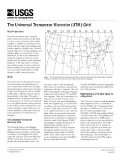
5 The scale of a map on any projection is always important and often crucial to the map's usefulness for a given purpose. For example, the almost grotesque distortion that is obvious at high latitudes on a small-scale Mercator map of the world disappears almost completely on a properly oriented large-scale Transverse Mercator map of a small area in the same high latitudes. A large-scale (1:24,000) USGS Topographic Map based on the Transverse Mercator projection is nearly correct in every respect. A basic knowledge of the properties of commonly used Projections helps in selecting a map that comes closest to fulfilling a specific need.
6 | Top | Main table of contents |. The Globe Globe, as represented by Orthographic projection equatorial aspect. Directions True Distances True Shapes True Areas True Great circles The shortest distance between any two points on the surface of the Earth can be found quickly and easily along a great circle. Disadvantages: Even the largest globe has a very small scale and shows relatively little detail. Costly to reproduce and update. Difficult to carry around. Bulky to store. On the globe: Parallels are parallel and spaced equally on meridians.
7 Meridians and other arcs of great circles are straight lines (if looked at perpendicularly to the Earth's surface). Meridians converge toward the poles and diverge toward the Equator. Meridians are equally spaced on the parallels, but their distances apart decreases from the Equator to the poles. At the Equator, meridians are spaced the same as parllels. Meridians at 60 are half as far apart as parallels. Parallels and meridians cross at right angles. The area of the surface bounded by any two parallels and any two meridians (a given distance apart) is the same anywhere between the same two Map Projections Poster parallels.
8 The scale factor at each point is the same in any direction. After Robinson and Sale, Elements of Cartography (3rd edition, John Wiley & Sons, Inc. 1969, ). | Top | Main table of contents |. Mercator Used for navigation or maps of equatorial regions. Any straight line on the map is a rhumb line (line of constant direction). Directions along a rhumb line are true between any two points on map, but a rhumb line is usually not the shortest distance between points. (Sometimes used with Gnomonic map on which any straight line is on a great circle and shows shortest path between two points).
9 Distances are true only along Equator, but are reasonably correct within 15 of Equator; special scales can be used to measure distances along other parallels. Two particular parallels can be made correct in scale instead of the Equator. Areas and shapes of large areas are distorted. Distortion increases away from Equator and is extreme in polar regions. Map, however, is conformal in that angles and shapes within any small area (such as that shown by USGS topographic map) is essentially true. The map is not perspective, equal area, or equidistant.
10 Equator and other parallels are straight lines (spacing increases toward poles) and meet meridians (equally spaced straight lines) at right angles. Poles are not shown. Presented by Mercator in 1569. Cylindrical Mathematically projected on a cylinder tangent to the Equator. (Cylinder may also be secant.). | Top | Main table of contents |. 3 of 20 12/28/2000 2:17 PM. Map Projections Poster Transverse Mercator Used by USGS for many quadrangle maps at scales from 1:24,000 to 1:250,000; such maps can be joined at their edges only if they are in the same zone with one central meridian.