Transcription of MASTER PLAN 2031 R - Noida Authority Online
1 1 Noida MASTER plan - 2031 2 CHAPTER 1 INTRODUCTION BACKGROUND The history of development of the present day Noida town can be traced back to 1972 when the Government of Uttar Pradesh, taking note of the mounting pressure of speculative land dealings in this area, closely situated to Delhi and having backward characteristics of development, declared 50 villages of the erstwhile district of Bulendshahar as the Yamuna-Hindon-Delhi Border Regulated area under the provisions of Regulation of Building Operations Act, 1958. There was no urban centre in this area. The Interim General plan for Greater Delhi was prepared in 1956 and then the first MASTER plan of Delhi prepared in 1962 suggested that serious considerations should be given for the planned decentralisation of large scale economic activities from Delhi and the development of towns around Delhi.
2 This paved ways for the development of Industrial units and warehousing at various locations around Delhi, resulting in speculative land dealings and potentials for unplanned and unauthorised development activities. Therefore, a need for establishing planned urban centres in the close proximity of Delhi was felt to provide an alternative site for the planned development of small and medium size industrial units functioning in unplanned and haphazard way in and around Delhi and to stop the speculative land dealings in this area. The controlling Authority of the newly declared Regulated Area considered various aspects of development of the Regulated Area but could not do much for the establishment of a new urban centre. Finally on April 17, 1976 the Government of Uttar Pradesh notified 36 villages of Yamuna-Hindon-Delhi Border Regulated Area as New Okhla Industrial Development Area wide its notification No.
3 Bha-U-18-(II), Lucknow, dated under the provisions of Industrial Development Act, 1976. The State Government also constituted a new statutory body, namely, the New Okhla Industrial Development Authority ( Noida ) to ensure planned development of the area for industrial and allied uses. Accordingly, the Authority prepared a MASTER plan for the area for the year 1991. The plan had the following objectives: i. Provide developed sites for about 10,000 small-scale industrial units; ii. Provide employment to about 41,000 industrial workers; and iii. Achieve a conducive living and work environment for the workers engaged in manufacturing and allied activities, and develop an integrated township for an ultimate population of 3,75,000 workers. However, even before the implementation of the plan could commence, the basic assumptions on which the plan was based had to be drastically recast.
4 The industrial experts felt that the plot sizes were too big for the kind of industrial units, which were envisaged to be located there. Likewise, the assumed workers densities were too low. On the basis of revised estimates, it was calculated that the 10,000 industrial sites would 3 provide employment to at least 220,000 workers and assuming a workers participation rate of percent, and town density of 148 persons per hectare, the design population of Noida was raised to one million. This was a large population to plan in an ecologically difficult area, due to the fact that most of it was formerly part of the Yamuna river basin and had been reclaimed by constructing embankments along the river. An Expert Committee was set-up to formulate an appropriate development strategy for the area.
5 The Committee recommended that the township should be planned for only 4,000 small-scale industrial units, which would provide employment to about 80,000 industrial workers. Accordingly, the design population of Noida was fixed at the level of 5,00,000. The urbanisable area for the new town was calculated about 3,360 hectare. Areas were allocated for community facilities as per the planning norms. Apart from appropriate transport facilities to link the new town with Delhi and other neighbouring cities such as Ghaziabad and Faridabad, it was envisaged that the internal transport system for Noida would also be connected with the proposed Mass Rapid Transit System (MRTS) for Delhi. Incorporating the recommendations of the Expert Committee, a revised MASTER plan was prepared for Noida in 1979, which was again revised in 1982 in response to rapidly changing development scenario in the area.
6 The Noida Authority approved the revised plan in 1983 for the perspective year of 2001 for public notification and inviting objections and suggestions from the general public. However, the plan was not publicly notified before finally seeking approval of the plan from the Authority since there was no such requirement in the Industrial Development Act. This plan was prepared for a projected population of lacs in 2001 and accordingly 3800 hectares land uses. It also projected one lac Industrial workers and about two lacs total work force in Noida by 2001. About six and a half years had already passed after the plan was first prepared and considerable changes had occurred in the land use pattern and socio-economic profile of the area. It had thus become imperative that the Draft plan should be reviewed as per the provisions of the Act and a Revised plan should be prepared based on the conclusions of the review.
7 The Noida Authority approved the revised MASTER plan in 1989 for the perspective year 2011 and 7650 hectare land was proposed to be urbanised under different land uses for lacs Population. In the meantime, a statutory plan for the National Capital Region of Delhi (of which Noida is a part) was finalised and enforced in 1988 for perspective year 2001. Also, a Perspective plan for Delhi - 2001 was finalised by the Delhi Development Authority and enforced since 1990 for the perspective year 2001. Both these Plans had significant implications for the development potential of Noida . Within the framework of the NCR plan , Noida was given the status of a Delhi Metropolitan Area (DMA) town with an assigned population of lakhs by the year 2001.
8 NCR Planning Board revised the Regional plan in 2005 for the perspective year of 2021. The Regional plan for the NCR 2021 has assigned the population of 12 lakhs for Noida and accorded it a status of Central NCR town. Another factor, which is likely to have far reaching implications for the growth 4 potential of Noida is the development of Greater Noida and Yamuna Expressway Industrial area townships on a contiguous territory east of the river Hindon. This territory had become a hot bed of speculative activity in the eighties, when the development of Noida had begun to take shape. The speculators had intensified their activity in the area since they perceived that the area had a high development potential in view of its close proximity to Delhi and also Noida , Ghaziabad, Faridabad and Gurgaon.
9 Besides, the area being situated on the periphery of a fertile hinterland of Haryana and western Uttar Pradesh was certain to benefit from the ensuing prosperity. The Government of Uttar Pradesh, with a view to curb haphazard developmental activities in this potential area, decided to acquire about 70,000 hectares of land for planned urban development. For this purpose, the State Government created the Greater Noida Industrial Development Authority (GNIDA) and later got a MASTER plan prepared for the development of a new city, namely, Greater Noida for a population of 300,000 to be achieved by the year 2001. Greater Noida is also now planned for a population of 12 lakhs by 2021. This city is also bound to expand in size with time, and being located in close proximity to Noida , would surely influence the development of the city.
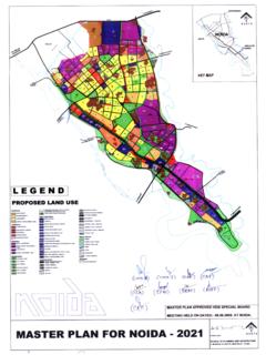
10 The state Government has notified the entire area between river Hindon and Yamuma under Noida , covering approximately 20316 hectare land and 81 villages. In this background, it was decided by the Authority to revise/amend the MASTER plan of Noida . The task of revising the MASTER plan was entrusted to a consultancy team of the School of Planning and Architecture, New Delhi. While the revised plan was being prepared, it was felt that since an expressway to link Noida with Greater Noida was proposed to be constructed in the immediate future, unplanned development (especially commercial uses) was likely to occur all along the length of the expressway in the absence of a plan to control such development. Since the expressway traverse the entire notified area of Noida , it was decided to get a MASTER plan prepared for the total area under the jurisdiction of the Noida Authority .